Lodi Marsh Wildlife Area: hunting and access
Lodi Marsh Wildlife Area is 1,281 acres of land managed by the Wisconsin DNR in Dane and Columbia counties, next to Lodi. The DNR's page for it names deer, wild turkey, pheasants, ducks and geese and rabbits and squirrels among the game here. Hunters registered 4,438 deer in Dane County in 2025.
Data updated October 2026. Area facts: the DNR's DNR property data, read 2026-10. Harvest: DNR Deer Metrics.
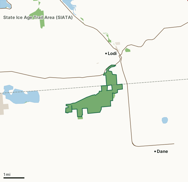
State wildlife areas, forests and other DNR landOther county, city and regional landLand trusts and other open landLodi Marsh Wildlife AreaCounty lineLakeHighway
| Size | 1,281 acres |
|---|---|
| Counties | Dane County and Columbia County |
| Deer Management Unit | Dane County, Columbia County |
| DNR lists for hunting | deer, wild turkey, pheasants, ducks and geese and rabbits and squirrels |
| Public access (DNR) | Open to Hiking, Fishing, Hunting and Trapping |
| DNR property page | Lodi Marsh Wildlife Area |
| Nearest towns | Lodi (next to it), Dane (3 mi) and Lake Wisconsin (5 mi) |
What is Lodi Marsh Wildlife Area like?
Lodi Marsh Wildlife Area is 1,183 acres on the Dane and Columbia county border. This property contains an intact and diverse mix of wetland and upland ecosystems in a very scenic setting. The Lodi Marsh State Natural Area located within the wildlife area, is a large wetland complex with numerous springs and spring runs, southern sedge meadow, fen, shallow marsh, shrub-carr with some cattail marsh and disturbed-low prairie. The principal upland habitat types are oak woodlands, oak openings, surrogate grasslands and small remnant dry prairie. The wildlife area provides excellent hunting opportunities for turkey, deer, squirrel and rabbit. Pheasant hunting opportunities are supported by the department's pheasant stocking program. The ongoing grassland restoration efforts are improving the quality of the habitat for grassland birds and pheasants.
Approximately 4 miles of the Ice Age Trail crosses the property and is regularly used by hikers and birders who enjoy the scenic vistas and natural setting. The Dane County Chapter of the Ice Age Trail Alliance helps maintain the trail as well as provide habitat improvements to the property. The management objectives for Lodi Marsh State Wildlife Area include:. Department staff and volunteers have been working to restore prairie, savannas and woodlands throughout the property using prescribed fire, reseeding of native plants and control of invasive plants. As funding allows, we are using a forestry mower to reclaim brush and trees that have taken over grass fields and the wetlands. Existing grassland units are being enlarged through the removal of trees that fragment adjacent fields.
In the DNR's words, from its page for the property.
What can you hunt on Lodi Marsh Wildlife Area?
The DNR's page for Lodi Marsh Wildlife Area names deer, wild turkey, pheasants, ducks and geese and rabbits and squirrels. Each follows Wisconsin's statewide season and, for deer, the tags and rules of the deer management unit.
What are the rules on Lodi Marsh Wildlife Area?
The DNR's property map lists Lodi Marsh Wildlife Area as "Open to Hiking, Fishing, Hunting and Trapping". Hunting follows Wisconsin's statewide seasons and the rules posted on the property.
Activities the DNR lists for Lodi Marsh Wildlife Area: Birding [exit DNR], Canoeing, Cross-country skiing (no designated trail), Firewood permits available upon request, Fishing, Hiking ( Ice Age Trail [exit DNR] ), Hunting (waterfowl, turkey, pheasant [stocked], deer, squirrel and rabbit), Trapping, Wild edibles/gathering and Wildlife viewing.
How many deer are taken around Lodi Marsh Wildlife Area?
Lodi Marsh Wildlife Area lies in 2 deer management units. The DNR registered 4,438 deer in Dane County in 2025, against 4,403 in 2024.
| DMU | Lodi Marsh Wildlife Area acres in it | Deer, 2025 | Deer, 2024 | Deer, 2023 |
|---|---|---|---|---|
| Dane County | 1,056 | 4,438 | 4,403 | 4,461 |
| Columbia County | 225 | 7,189 | 7,176 | 6,629 |
Harvest for the whole deer management unit, not the property alone: Wisconsin DNR Deer Metrics (registered harvest by deer management unit).
How do you get to Lodi Marsh Wildlife Area?
Nearest towns: Lodi (next to it), Dane (3 miles), Lake Wisconsin (5 miles) and Merrimac (7 miles). Highways within 5 miles: WI 60, WI 113, I-90, I-94 and I-39.
What other public land is near Lodi Marsh Wildlife Area?
DNR properties within 10 miles:
- State Ice Age Trail Area (SIATA): 4,676 acres, next to it
- Lodi Spring Creek Fishery Area: 53 acres, 0.8 miles away
- Lower Wisconsin State Riverway: 47,767 acres, 5.7 miles away
- Waunakee Wildlife Area: 482 acres, 5.8 miles away
- Great Sauk State Trail: 106 acres, 6.8 miles away
- Rowan Creek Fishery Area: 651 acres, 7.1 miles away
Public land within 3 miles of Lodi Marsh Wildlife Area
Counting Lodi Marsh Wildlife Area itself, 1,503 of the 35,384 acres within 3 miles of its boundary are public land open to the public (4.2%), by USGS PAD-US 4.1 (fee land open to the public).
| Manager | Acres within 3 miles |
|---|---|
| State wildlife areas, forests and other DNR land | 1,413 |
| Other county, city and regional land | 72 |
| Land trusts and other open land | 18 |
Questions hunters ask
Where is Lodi Marsh Wildlife Area?
In Dane and Columbia counties, next to Lodi. The DNR's property page has its maps and parking.
Is Lodi Marsh Wildlife Area open to hunting?
Yes. The DNR's property map lists it as "Open to Hiking, Fishing, Hunting and Trapping". Posted refuges or closed areas, where there are any, are marked on site.
Which deer management unit is Lodi Marsh Wildlife Area in?
Dane County (1,056 acres) and Columbia County (225 acres).
How much public land is around Lodi Marsh Wildlife Area?
1,503 acres within 3 miles of its boundary, Lodi Marsh Wildlife Area included, by PAD-US 4.1. The closest other DNR property is State Ice Age Trail Area (SIATA) (next to it).
Get a Wisconsin hunt plan when they open
Hunt plans for Wisconsin are coming. Join the list and you'll hear first. The first 50 hunters in each new state get their plan free.
Until then, the free FilledTag app for iPhone has a map that works in every state, Wisconsin included.
Where these facts come from
- Area description, species, rules and directions: DNR, Lodi Marsh Wildlife Area; Wisconsin DNR managed lands open to hunting.
- Boundary and acres: the DNR's map layer above. Surrounding public land: USGS PAD-US 4.1 (fee land open to the public).
- Deer harvest: Wisconsin DNR Deer Metrics (registered harvest by deer management unit).
FilledTag is not part of the Wisconsin Department of Natural Resources. Check the DNR's rules and posted signs before you go.
Wisconsin hunting Dane County Columbia County Dane County Columbia County