Rowan Creek Fishery Area: hunting and access
Rowan Creek Fishery Area is 651 acres of land managed by the Wisconsin DNR in Columbia County, next to Poynette. Hunters registered 7,189 deer in Columbia County in 2025.
Data updated October 2026. Area facts: the DNR's DNR property data, read 2026-10. Harvest: DNR Deer Metrics.
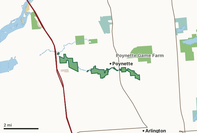
State wildlife areas, forests and other DNR landNational wildlife refuges and waterfowl production areasOther federal landOther county, city and regional landRowan Creek Fishery AreaCounty lineLakeHighway
| Size | 651 acres in 12 pieces |
|---|---|
| County | Columbia County |
| Deer Management Unit | Columbia County |
| Public access (DNR) | Open to Hiking, Fishing, Hunting and Trapping |
| DNR property page | Rowan Creek Fishery Area |
| Nearest towns | Poynette (next to it), Arlington (3 mi) and Dekorra (3 mi) |
What is Rowan Creek Fishery Area like?
While the dominant species is brown trout, stream surveys have reported many other native fish such as brook trout, mottled sculpin, white sucker, American brook lamprey (a native, non-parasitic lamprey) brook stickleback, central mud minnow, black bullhead, and fathead minnow. Rowan creek is typically stocked with brown trout and rainbow trout. Rowan Creek Fishery Area is a 651-acre property located 1 mile east of Poynette on US Hwy 51 and 2 miles west of Poynette on County Hwy CS in Columbia County.
Primary angling activities include fly fishing and angling via shore and wading. Rowan Creek is primarily managed for trout.
In the DNR's words, from its page for the property.
What are the rules on Rowan Creek Fishery Area?
The DNR's property map lists Rowan Creek Fishery Area as "Open to Hiking, Fishing, Hunting and Trapping". Hunting follows Wisconsin's statewide seasons and the rules posted on the property.
Activities the DNR lists for Rowan Creek Fishery Area: Trapping, Hiking and Cross-country skiing.
How many deer are taken around Rowan Creek Fishery Area?
Rowan Creek Fishery Area lies in Columbia County. The DNR registered 7,189 deer in Columbia County in 2025, against 7,176 in 2024.
| DMU | Rowan Creek Fishery Area acres in it | Deer, 2025 | Deer, 2024 | Deer, 2023 |
|---|---|---|---|---|
| Columbia County | 651 | 7,189 | 7,176 | 6,629 |
Harvest for the whole deer management unit, not the property alone: Wisconsin DNR Deer Metrics (registered harvest by deer management unit).
How do you get to Rowan Creek Fishery Area?
Nearest towns: Poynette (next to it), Arlington (3 miles), Dekorra (3 miles) and Lodi (7 miles). Highways within 5 miles: I-90, I-94, I-39, US 51 and WI 60.
What other public land is near Rowan Creek Fishery Area?
DNR properties within 10 miles:
- Poynette Game Farm: 625 acres, 0.5 miles away
- Hinkson Creek Fishery Area: 235 acres, 0.8 miles away
- Mud Lake Wildlife Area-Columbia: 2,281 acres, 2.7 miles away
- Rocky Run Creek Fishery Area: 741 acres, 4.3 miles away
- Rocky Run Oak Savanna State Natural Area: 164 acres, 4.8 miles away
- Lost Lake State Natural Area: 169 acres, 5.8 miles away
Public land within 3 miles of Rowan Creek Fishery Area
Counting Rowan Creek Fishery Area itself, 2,382 of the 40,212 acres within 3 miles of its boundary are public land open to the public (5.9%), by USGS PAD-US 4.1 (fee land open to the public).
| Manager | Acres within 3 miles |
|---|---|
| State wildlife areas, forests and other DNR land | 1,858 |
| National wildlife refuges and waterfowl production areas | 337 |
| Other federal land | 106 |
| Other county, city and regional land | 80 |
| Land trusts and other open land | 1 |
Questions hunters ask
Where is Rowan Creek Fishery Area?
In Columbia County, next to Poynette. The DNR's property page has its maps and parking.
Is Rowan Creek Fishery Area open to hunting?
Yes. The DNR's property map lists it as "Open to Hiking, Fishing, Hunting and Trapping". Posted refuges or closed areas, where there are any, are marked on site.
Which deer management unit is Rowan Creek Fishery Area in?
Columbia County.
How much public land is around Rowan Creek Fishery Area?
2,382 acres within 3 miles of its boundary, Rowan Creek Fishery Area included, by PAD-US 4.1. The closest other DNR property is Poynette Game Farm (0.5 miles).
Get a Wisconsin hunt plan when they open
Hunt plans for Wisconsin are coming. Join the list and you'll hear first. The first 50 hunters in each new state get their plan free.
Until then, the free FilledTag app for iPhone has a map that works in every state, Wisconsin included.
Where these facts come from
- Area description, species, rules and directions: DNR, Rowan Creek Fishery Area; Wisconsin DNR managed lands open to hunting.
- Boundary and acres: the DNR's map layer above. Surrounding public land: USGS PAD-US 4.1 (fee land open to the public).
- Deer harvest: Wisconsin DNR Deer Metrics (registered harvest by deer management unit).
FilledTag is not part of the Wisconsin Department of Natural Resources. Check the DNR's rules and posted signs before you go.