Hinkson Creek Fishery Area: hunting and access
Hinkson Creek Fishery Area is 235 acres of land managed by the Wisconsin DNR in Columbia County, next to Poynette. The DNR's page for it names deer, ducks and geese and small game among the game here. Hunters registered 7,189 deer in Columbia County in 2025.
Data updated October 2026. Area facts: the DNR's DNR property data, read 2026-10. Harvest: DNR Deer Metrics.
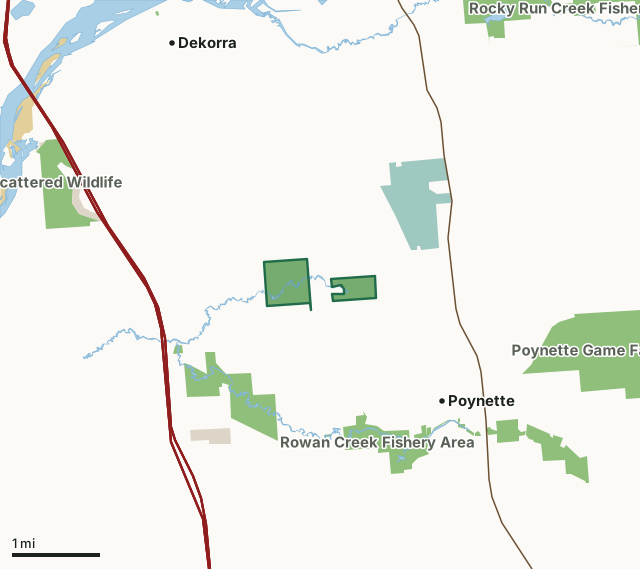
State wildlife areas, forests and other DNR landNational wildlife refuges and waterfowl production areasOther federal landOther county, city and regional landHinkson Creek Fishery AreaCounty lineLakeHighway
| Size | 235 acres in 2 pieces |
|---|---|
| County | Columbia County |
| Deer Management Unit | Columbia County |
| DNR lists for hunting | deer, ducks and geese and small game |
| Public access (DNR) | Open to Hiking, Fishing, Hunting and Trapping |
| DNR property page | Hinkson Creek Fishery Area |
| Nearest towns | Poynette (next to it), Dekorra (3 mi) and Arlington (6 mi) |
What is Hinkson Creek Fishery Area like?
Thirty-nine mammal species may inhabit the area. Those species which can be managed for hunting or trapping include muskrat, raccoon, red fox, mink, white-tailed deer, fox and gray squirrels and cottontail rabbits. Beaver are known to inhabit the stream. The presence of 153 bird species has been documented in the area of the Columbia Generating Station and may also be present on the fishery area. Those of interest for hunting purposes include the common waterfowl species, ring-necked pheasants, woodcocks and ruffed grouse. It is likely such endangered species as the bald eagle and osprey, along with the threatened red-shouldered hawk and loggerhead shrike, pass through the area. Sandhill cranes have been sighted along Hinkson Creek. Cranes may nest within the proposed boundary.
Ten species of amphibians and 10 species of reptiles have been documented in the area. The abundance of wetlands associated with Hinkson Creek, while important in maintaining excellent water quality of the stream, also provide valuable wildlife habitat. This 233-acre fishery area contains at least one archaeological site and possibly more. Data collected by the State Historical Society in the early 1900s indicate that there were an Indian village and a campsite within or on the edge of the fishery area boundary. Hinkson Creek Fishery Area is located in south central Wisconsin in southwest Columbia County. Hinkson Creek flows just north of the Village of Poynette, 25 miles north of Madison and 11 miles south of Portage. US Hwy 51 crosses the headwaters region of the creek and Interstate 90/94 lies immediately downstream from its confluence with Rowan Creek.
In the DNR's words, from its page for the property.
What can you hunt on Hinkson Creek Fishery Area?
The DNR's page for Hinkson Creek Fishery Area names deer, ducks and geese and small game. Each follows Wisconsin's statewide season and, for deer, the tags and rules of the deer management unit.
What are the rules on Hinkson Creek Fishery Area?
The DNR's property map lists Hinkson Creek Fishery Area as "Open to Hiking, Fishing, Hunting and Trapping". Hunting follows Wisconsin's statewide seasons and the rules posted on the property.
Activities the DNR lists for Hinkson Creek Fishery Area: Hunting - deer, waterfowl & small game, Trapping, Hiking and Wildlife viewing.
How many deer are taken around Hinkson Creek Fishery Area?
Hinkson Creek Fishery Area lies in Columbia County. The DNR registered 7,189 deer in Columbia County in 2025, against 7,176 in 2024.
| DMU | Hinkson Creek Fishery Area acres in it | Deer, 2025 | Deer, 2024 | Deer, 2023 |
|---|---|---|---|---|
| Columbia County | 235 | 7,189 | 7,176 | 6,629 |
Harvest for the whole deer management unit, not the property alone: Wisconsin DNR Deer Metrics (registered harvest by deer management unit).
How do you get to Hinkson Creek Fishery Area?
Nearest towns: Poynette (next to it), Dekorra (3 miles), Arlington (6 miles) and Wyocena (8 miles). Highways within 5 miles: I-90, I-94, I-39, US 51 and WI 22.
What other public land is near Hinkson Creek Fishery Area?
DNR properties within 10 miles:
- Rowan Creek Fishery Area: 651 acres, 0.8 miles away
- Poynette Game Farm: 625 acres, 1.9 miles away
- Rocky Run Creek Fishery Area: 741 acres, 2.9 miles away
- Rocky Run Oak Savanna State Natural Area: 164 acres, 3.8 miles away
- Mud Lake Wildlife Area-Columbia: 2,281 acres, 4.7 miles away
- Lost Lake State Natural Area: 169 acres, 5.8 miles away
Public land within 3 miles of Hinkson Creek Fishery Area
Counting Hinkson Creek Fishery Area itself, 2,018 of the 24,787 acres within 3 miles of its boundary are public land open to the public (8.1%), by USGS PAD-US 4.1 (fee land open to the public).
| Manager | Acres within 3 miles |
|---|---|
| State wildlife areas, forests and other DNR land | 1,600 |
| National wildlife refuges and waterfowl production areas | 337 |
| Other county, city and regional land | 80 |
| Land trusts and other open land | 1 |
Questions hunters ask
Where is Hinkson Creek Fishery Area?
In Columbia County, next to Poynette. The DNR's property page has its maps and parking.
Is Hinkson Creek Fishery Area open to hunting?
Yes. The DNR's property map lists it as "Open to Hiking, Fishing, Hunting and Trapping". Posted refuges or closed areas, where there are any, are marked on site.
Which deer management unit is Hinkson Creek Fishery Area in?
Columbia County.
How much public land is around Hinkson Creek Fishery Area?
2,018 acres within 3 miles of its boundary, Hinkson Creek Fishery Area included, by PAD-US 4.1. The closest other DNR property is Rowan Creek Fishery Area (0.8 miles).
Get a Wisconsin hunt plan when they open
Hunt plans for Wisconsin are coming. Join the list and you'll hear first. The first 50 hunters in each new state get their plan free.
Until then, the free FilledTag app for iPhone has a map that works in every state, Wisconsin included.
Where these facts come from
- Area description, species, rules and directions: DNR, Hinkson Creek Fishery Area; Wisconsin DNR managed lands open to hunting.
- Boundary and acres: the DNR's map layer above. Surrounding public land: USGS PAD-US 4.1 (fee land open to the public).
- Deer harvest: Wisconsin DNR Deer Metrics (registered harvest by deer management unit).
FilledTag is not part of the Wisconsin Department of Natural Resources. Check the DNR's rules and posted signs before you go.