Lost Lake State Natural Area: hunting and access
Lost Lake State Natural Area is 169 acres of land managed by the Wisconsin DNR in Columbia County, 4 miles from Dekorra. Hunters registered 7,189 deer in Columbia County in 2025.
Data updated October 2026. Area facts: the DNR's DNR property data, read 2026-10. Harvest: DNR Deer Metrics.
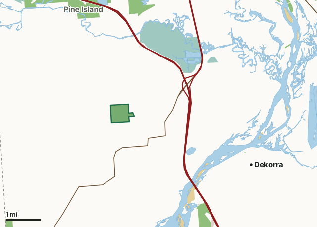
State wildlife areas, forests and other DNR landNational wildlife refuges and waterfowl production areasOther federal landState parksOther county, city and regional landLost Lake State Natural AreaCounty lineLakeHighway
| Size | 169 acres |
|---|---|
| County | Columbia County |
| Deer Management Unit | Columbia County |
| Public access (DNR) | Open to Hiking, Fishing, Hunting and Trapping |
| DNR property page | Lost Lake |
| Nearest towns | Dekorra (4 mi), Portage (6 mi) and Lake Wisconsin (8 mi) |
What is Lost Lake State Natural Area like?
Lost Lake is a small kettle-type depression in ground moraine deposits overlying the eastern end of the Baraboo Range. This deep, circular hard water lake is perched near the upper end of a ravine about 0.2 miles wide and 0.5 miles long and drains to the northwest. Large quartzite boulders and exposures of quartzite conglomerate and layers of sandstone cover the north-facing slope. This area harbors a shaded cliff community with numerous ferns and mountain maple. The bottom of the hollow supports a well-established lowland forest with yellow birch, black ash, green ash, hackberry, American elm, and poison sumac. On the slopes, the forest grades into red oak, basswood, yellow birch, hackberry, and white ash with white oak predominant further upslope. Surrounding the 2-acre lake is a zone of swamp loosestrife and a large alder thicket.
Columbia County. T12N-R8E, Section 34. 169 acres. From the intersection of I-90/94 and State Highway 78 west of Portage, go west on Highway 78 for 2 miles, then north on Beich Road one mile to a DNR parking area west of the road. Walk west into the natural area.
In the DNR's words, from its page for the property.
What are the rules on Lost Lake State Natural Area?
The DNR's property map lists Lost Lake State Natural Area as "Open to Hiking, Fishing, Hunting and Trapping". Hunting follows Wisconsin's statewide seasons and the rules posted on the property.
How many deer are taken around Lost Lake State Natural Area?
Lost Lake State Natural Area lies in Columbia County. The DNR registered 7,189 deer in Columbia County in 2025, against 7,176 in 2024.
| DMU | Lost Lake State Natural Area acres in it | Deer, 2025 | Deer, 2024 | Deer, 2023 |
|---|---|---|---|---|
| Columbia County | 169 | 7,189 | 7,176 | 6,629 |
Harvest for the whole deer management unit, not the property alone: Wisconsin DNR Deer Metrics (registered harvest by deer management unit).
How do you get to Lost Lake State Natural Area?
Nearest towns: Dekorra (4 miles), Portage (6 miles), Lake Wisconsin (8 miles) and Merrimac (8 miles). Highways within 5 miles: I-90, I-94, I-39, WI 78 and WI 33.
What other public land is near Lost Lake State Natural Area?
DNR properties within 10 miles:
- Pine Island Wildlife Area: 5,615 acres, 2.5 miles away
- Baraboo Hills State Recreation Area: 1,143 acres, 3.9 miles away
- State Ice Age Trail Area (SIATA): 4,676 acres, 4.9 miles away
- Lower Narrows State Natural Area: 107 acres, 5 miles away
Public land within 3 miles of Lost Lake State Natural Area
Counting Lost Lake State Natural Area itself, 1,619 of the 22,271 acres within 3 miles of its boundary are public land open to the public (7.3%), by USGS PAD-US 4.1 (fee land open to the public).
| Manager | Acres within 3 miles |
|---|---|
| National wildlife refuges and waterfowl production areas | 955 |
| State wildlife areas, forests and other DNR land | 545 |
| Other federal land | 119 |
Questions hunters ask
Where is Lost Lake State Natural Area?
In Columbia County, 4 miles from Dekorra. The DNR's property page has its maps and parking.
Is Lost Lake State Natural Area open to hunting?
Yes. The DNR's property map lists it as "Open to Hiking, Fishing, Hunting and Trapping". Posted refuges or closed areas, where there are any, are marked on site.
Which deer management unit is Lost Lake State Natural Area in?
Columbia County.
How much public land is around Lost Lake State Natural Area?
1,619 acres within 3 miles of its boundary, Lost Lake State Natural Area included, by PAD-US 4.1. The closest other DNR property is Pine Island Wildlife Area (2.5 miles).
Get a Wisconsin hunt plan when they open
Hunt plans for Wisconsin are coming. Join the list and you'll hear first. The first 50 hunters in each new state get their plan free.
Until then, the free FilledTag app for iPhone has a map that works in every state, Wisconsin included.
Where these facts come from
- Area description, species, rules and directions: DNR, Lost Lake State Natural Area; Wisconsin DNR managed lands open to hunting.
- Boundary and acres: the DNR's map layer above. Surrounding public land: USGS PAD-US 4.1 (fee land open to the public).
- Deer harvest: Wisconsin DNR Deer Metrics (registered harvest by deer management unit).
FilledTag is not part of the Wisconsin Department of Natural Resources. Check the DNR's rules and posted signs before you go.