Pine Island Wildlife Area: hunting and access
Pine Island Wildlife Area is 5,615 acres of land managed by the Wisconsin DNR in Columbia and Sauk counties, next to Portage. Hunters registered 7,189 deer in Columbia County in 2025.
Data updated October 2026. Area facts: the DNR's DNR property data, read 2026-10. Harvest: DNR Deer Metrics.
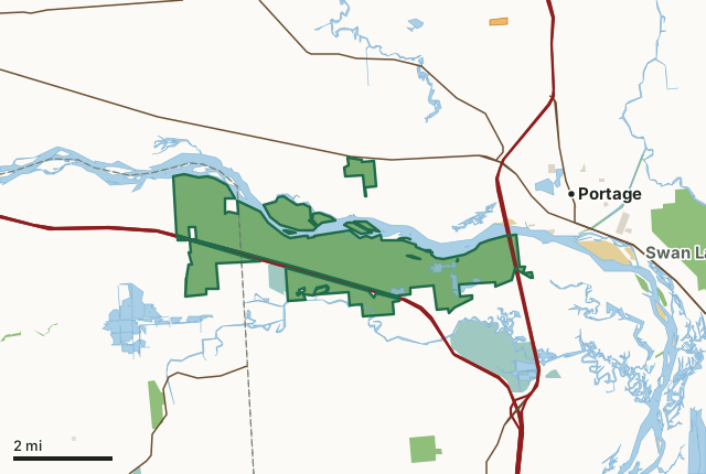
State wildlife areas, forests and other DNR landNational wildlife refuges and waterfowl production areasOther federal landOther county, city and regional landLand trusts and other open landVoluntary Public Access landPine Island Wildlife AreaCounty lineLakeHighway
| Size | 5,615 acres in 15 pieces |
|---|---|
| Counties | Columbia County and Sauk County |
| Deer Management Unit | Columbia County, Sauk County |
| Public access (DNR) | Open to Hiking, Fishing, Hunting and Trapping |
| DNR property page | Pine Island Wildlife Area |
| Nearest towns | Portage (next to it), Dekorra (5 mi) and Briggsville (7 mi) |
What is Pine Island Wildlife Area like?
Pine Island Wildlife Area is a 5,499-acre property located in Columbia and Sauk Counties west of Portage. The property consists of approximately 900 acres of wetlands, 1,300 acres of grasslands, 700 acres of oak/savanna habitats and 2,600 acres of forested habitat. Pine Island Wildlife Area lies in the floodplains of the Wisconsin and Baraboo Rivers and includes several islands of the Wisconsin River. The largest of the islands in this area referred to as “Pine Island”, is the namesake for this wildlife area. Prior to most urban and agricultural development in the area, the island was home to a significant stand of white pine. Much of this pine stand was removed in the early 1900s by settlers for the construction of barns. Pine Island, along with another portion of Pine Island Wildlife Area, is designated as a State Natural Area.
The floodplain area between the two rivers was originally farmed by early settlers. To drain the area for farming, a hand-dug ditch was installed and remains in a wetland portion of the area. Between 1890 and 1900, a levee was constructed by the Corps of Engineers on the south and north sides of the Wisconsin River as flood protection for the city of Portage and the farmlands along the river. The levee on the south side of the Wisconsin River runs the entire length of Pine Island Wildlife Area on the north side of Levee Road. Maintenance of this levee is the responsibility of Department of Natural Resources personnel. Pine Island Wildlife Area was established in 1952. A private businessman from Portage, Ross Bennett, was influential in promoting the idea of establishing a wildlife area along the Wisconsin River west of Portage.
In the DNR's words, from its page for the property.
What are the rules on Pine Island Wildlife Area?
The DNR's property map lists Pine Island Wildlife Area as "Open to Hiking, Fishing, Hunting and Trapping". Hunting follows Wisconsin's statewide seasons and the rules posted on the property.
Activities the DNR lists for Pine Island Wildlife Area: Birding, Boating (motorized and non-motorized, only on the Wisconsin River), Cross-country skiing (no designated trail) and Canoeing.
How many deer are taken around Pine Island Wildlife Area?
Pine Island Wildlife Area lies in 2 deer management units. The DNR registered 7,189 deer in Columbia County in 2025, against 7,176 in 2024.
| DMU | Pine Island Wildlife Area acres in it | Deer, 2025 | Deer, 2024 | Deer, 2023 |
|---|---|---|---|---|
| Columbia County | 4,227 | 7,189 | 7,176 | 6,629 |
| Sauk County | 1,388 | 6,025 | 5,739 | 6,262 |
Harvest for the whole deer management unit, not the property alone: Wisconsin DNR Deer Metrics (registered harvest by deer management unit).
How do you get to Pine Island Wildlife Area?
Nearest towns: Portage (next to it), Dekorra (5 miles), Briggsville (7 miles) and Baraboo (7 miles). Highways within 5 miles: I-90, I-94, WI 78, I-39 and WI 16.
What other public land is near Pine Island Wildlife Area?
DNR properties within 10 miles:
- Upper Fox River Public Access: 401 acres, 1.2 miles away
- State Ice Age Trail Area (SIATA): 4,676 acres, 1.8 miles away
- Lower Narrows State Natural Area: 107 acres, 2 miles away
- Swan Lake Wildlife Area: 2,502 acres, 2.1 miles away
- Lost Lake State Natural Area: 169 acres, 2.5 miles away
Public land within 3 miles of Pine Island Wildlife Area
Counting Pine Island Wildlife Area itself, 7,753 of the 62,357 acres within 3 miles of its boundary are public land open to the public (12.4%), by USGS PAD-US 4.1 (fee land open to the public).
| Manager | Acres within 3 miles |
|---|---|
| State wildlife areas, forests and other DNR land | 6,293 |
| National wildlife refuges and waterfowl production areas | 1,079 |
| Other federal land | 282 |
| Other county, city and regional land | 99 |
Questions hunters ask
Where is Pine Island Wildlife Area?
In Columbia and Sauk counties, next to Portage. The DNR's property page has its maps and parking.
Is Pine Island Wildlife Area open to hunting?
Yes. The DNR's property map lists it as "Open to Hiking, Fishing, Hunting and Trapping". Posted refuges or closed areas, where there are any, are marked on site.
Which deer management unit is Pine Island Wildlife Area in?
Columbia County (4,227 acres) and Sauk County (1,388 acres).
How much public land is around Pine Island Wildlife Area?
7,753 acres within 3 miles of its boundary, Pine Island Wildlife Area included, by PAD-US 4.1. The closest other DNR property is Upper Fox River Public Access (1.2 miles).
Get a Wisconsin hunt plan when they open
Hunt plans for Wisconsin are coming. Join the list and you'll hear first. The first 50 hunters in each new state get their plan free.
Until then, the free FilledTag app for iPhone has a map that works in every state, Wisconsin included.
Where these facts come from
- Area description, species, rules and directions: DNR, Pine Island Wildlife Area; Wisconsin DNR managed lands open to hunting.
- Boundary and acres: the DNR's map layer above. Surrounding public land: USGS PAD-US 4.1 (fee land open to the public).
- Deer harvest: Wisconsin DNR Deer Metrics (registered harvest by deer management unit).
FilledTag is not part of the Wisconsin Department of Natural Resources. Check the DNR's rules and posted signs before you go.
Wisconsin hunting Columbia County Sauk County Columbia County Sauk County