Lower Mud Lake Fishery Area: hunting and access
Lower Mud Lake Fishery Area is 410 acres of land managed by the Wisconsin DNR in Dane County, next to McFarland. Hunters registered 4,438 deer in Dane County in 2025.
Data updated October 2026. Area facts: the DNR's DNR property data, read 2026-10. Harvest: DNR Deer Metrics.
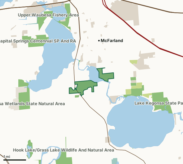
State wildlife areas, forests and other DNR landCounty forestNational wildlife refuges and waterfowl production areasState parksOther county, city and regional landLand trusts and other open landLower Mud Lake Fishery AreaCounty lineLakeHighway
| Size | 410 acres in 3 pieces |
|---|---|
| County | Dane County |
| Deer Management Unit | Dane County |
| Public access (DNR) | Open to Hiking, Fishing, Hunting and Trapping |
| DNR property page | Lower Mud Lake Fishery Area |
| Nearest towns | McFarland (next to it), Monona (4 mi) and Stoughton (6 mi) |
What is Lower Mud Lake Fishery Area like?
This wetland is extensive and has long met the life history and spawning needs of native northern pike populations. It represents a significant pass through area for walleye migrating to spawning riffles upstream. Waterfowl flock to the Lower Mud Lake Fishery Area as resting, feeding, and nesting grounds during spring and fall migrations. Access to the Lower Mud Lake Fishery Area is practicably restricted to access by water. From the Village of McFarland, access is from the Jaeger Landing off of Exchange Street, south of the outlet of Lake Waubesa on US Hwy 51. Access can also be had from the property's south side via a county easement east of the bridge on Dryeson Road. From either direction, the rocky nature of the Yahara River restricts access to small, shallow draft boats or canoe and kayak. Hidden Farm Road dead-ends on the property's eastern edge south from Elvehjem Road.
No overnight camping or fires are allowed. Signage indicates permitted and prohibited uses.
In the DNR's words, from its page for the property.
What are the rules on Lower Mud Lake Fishery Area?
The DNR's property map lists Lower Mud Lake Fishery Area as "Open to Hiking, Fishing, Hunting and Trapping". Hunting follows Wisconsin's statewide seasons and the rules posted on the property.
Activities the DNR lists for Lower Mud Lake Fishery Area: Hunting, Trapping, Hiking (no established trails), Wildlife viewing and Fishing.
How many deer are taken around Lower Mud Lake Fishery Area?
Lower Mud Lake Fishery Area lies in Dane County. The DNR registered 4,438 deer in Dane County in 2025, against 4,403 in 2024.
| DMU | Lower Mud Lake Fishery Area acres in it | Deer, 2025 | Deer, 2024 | Deer, 2023 |
|---|---|---|---|---|
| Dane County | 410 | 4,438 | 4,403 | 4,461 |
Harvest for the whole deer management unit, not the property alone: Wisconsin DNR Deer Metrics (registered harvest by deer management unit).
How do you get to Lower Mud Lake Fishery Area?
Nearest towns: McFarland (next to it), Monona (4 miles), Stoughton (6 miles) and Fitchburg (6 miles). Highways within 5 miles: US 18, US 12, I-39, I-90 and US 51.
What other public land is near Lower Mud Lake Fishery Area?
DNR properties within 10 miles:
- Lake Kegonsa Rough Fish Station: 20 acres, 0.8 miles away
- Waubesa Wetlands State Natural Area: 210 acres, 1.7 miles away
- Lake Waubesa Fishery Area: 22 acres, 1.8 miles away
- Lake Kegonsa State Park: 355 acres, 1.8 miles away
- Hook Lake/Grass Lake Wildlife And Natural Area: 875 acres, 1.9 miles away
- Capital Springs Centennial SP And RA: 356 acres, 2.1 miles away
Public land within 3 miles of Lower Mud Lake Fishery Area
Counting Lower Mud Lake Fishery Area itself, 3,410 of the 28,522 acres within 3 miles of its boundary are public land open to the public (12%), by USGS PAD-US 4.1 (fee land open to the public).
| Manager | Acres within 3 miles |
|---|---|
| State wildlife areas, forests and other DNR land | 1,940 |
| Other county, city and regional land | 1,109 |
| Land trusts and other open land | 188 |
| County forest | 162 |
| State parks | 11 |
Questions hunters ask
Where is Lower Mud Lake Fishery Area?
In Dane County, next to McFarland. The DNR's property page has its maps and parking.
Is Lower Mud Lake Fishery Area open to hunting?
Yes. The DNR's property map lists it as "Open to Hiking, Fishing, Hunting and Trapping". Posted refuges or closed areas, where there are any, are marked on site.
Which deer management unit is Lower Mud Lake Fishery Area in?
Dane County.
How much public land is around Lower Mud Lake Fishery Area?
3,410 acres within 3 miles of its boundary, Lower Mud Lake Fishery Area included, by PAD-US 4.1. The closest other DNR property is Lake Kegonsa Rough Fish Station (0.8 miles).
Get a Wisconsin hunt plan when they open
Hunt plans for Wisconsin are coming. Join the list and you'll hear first. The first 50 hunters in each new state get their plan free.
Until then, the free FilledTag app for iPhone has a map that works in every state, Wisconsin included.
Where these facts come from
- Area description, species, rules and directions: DNR, Lower Mud Lake Fishery Area; Wisconsin DNR managed lands open to hunting.
- Boundary and acres: the DNR's map layer above. Surrounding public land: USGS PAD-US 4.1 (fee land open to the public).
- Deer harvest: Wisconsin DNR Deer Metrics (registered harvest by deer management unit).
FilledTag is not part of the Wisconsin Department of Natural Resources. Check the DNR's rules and posted signs before you go.