Waubesa Wetlands State Natural Area: hunting and access
Waubesa Wetlands State Natural Area is 210 acres of land managed by the Wisconsin DNR in Dane County, 3 miles from Fitchburg. Hunters registered 4,438 deer in Dane County in 2025.
Data updated October 2026. Area facts: the DNR's DNR property data, read 2026-10. Harvest: DNR Deer Metrics.
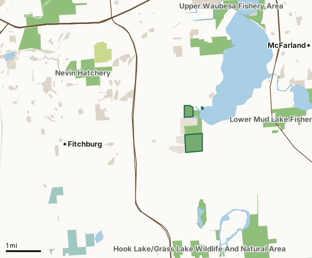
State wildlife areas, forests and other DNR landCounty forestNational wildlife refuges and waterfowl production areasState parksOther county, city and regional landLand trusts and other open landWaubesa Wetlands State Natural AreaCounty lineLakeHighway
| Size | 210 acres in 3 pieces |
|---|---|
| County | Dane County |
| Deer Management Unit | Dane County |
| Public access (DNR) | Open to Hiking, Fishing, Hunting and Trapping |
| DNR property page | Waubesa Wetlands |
| Nearest towns | Fitchburg (3 mi), McFarland (3 mi) and Monona (4 mi) |
What is Waubesa Wetlands State Natural Area like?
Located in an old lobe of Lake Waubesa along its southwest shore, Waubesa Wetlands is one of the highest quality and most diverse wetlands remaining in southern Wisconsin. Nine major springs and numerous smaller ones located within and around the area provide the wetland with an abundance of high-quality water. The extensive wetlands and high quality of the water contribute significantly to the water quality of Lake Waubesa. Two inlet streams are also present - Murphy Creek and Swan Creek. Peat deposits - up to 95' deep in places - underlie a mix of sedge meadow, fen, and shrub-carr communities. The sedge meadow is a complex of different species that vary in abundance and structure in response to the complex hydrological system.
Dane County. T6N-R10E, Section 7, 8, 17, 18. 566 acres. Highway 14 and County Highway MM south of Madison, go south on MM for 1.3 miles, then east on Goodland Park Road for 0.9 miles, then south on Lalor Road for 0.8 miles to a parking area east of the road. The parking lot and adjacent access lane are owned by The Nature Conservancy. Visitors (no dogs) are welcome to use both to access DNR lands. An additional DNR-owned walk-in access lane is further South on Lalor Rd.5 miles from the parking lot. Canoe access is via Lake Waubesa from the canoe landing at Goodland County Park at the end of Goodland Park Road. Waubesa Wetlands is owned by: The Nature Conservancy, Wisconsin DNR, Dane County and Private.
In the DNR's words, from its page for the property.
What are the rules on Waubesa Wetlands State Natural Area?
The DNR's property map lists Waubesa Wetlands State Natural Area as "Open to Hiking, Fishing, Hunting and Trapping". Hunting follows Wisconsin's statewide seasons and the rules posted on the property.
How many deer are taken around Waubesa Wetlands State Natural Area?
Waubesa Wetlands State Natural Area lies in Dane County. The DNR registered 4,438 deer in Dane County in 2025, against 4,403 in 2024.
| DMU | Waubesa Wetlands State Natural Area acres in it | Deer, 2025 | Deer, 2024 | Deer, 2023 |
|---|---|---|---|---|
| Dane County | 210 | 4,438 | 4,403 | 4,461 |
Harvest for the whole deer management unit, not the property alone: Wisconsin DNR Deer Metrics (registered harvest by deer management unit).
How do you get to Waubesa Wetlands State Natural Area?
Nearest towns: Fitchburg (3 miles), McFarland (3 miles), Monona (4 miles) and Oregon (4 miles). Highways within 5 miles: US 14, US 18, US 12, US 51 and US 151.
What other public land is near Waubesa Wetlands State Natural Area?
DNR properties within 10 miles:
- Lake Waubesa Fishery Area: 22 acres, next to it
- Hook Lake/Grass Lake Wildlife And Natural Area: 875 acres, 1.4 miles away
- Capital Springs Centennial SP And RA: 356 acres, 1.5 miles away
- Lower Mud Lake Fishery Area: 410 acres, 1.7 miles away
- Upper Waubesa Fishery Area: 252 acres, 2.2 miles away
- Nevin Hatchery: 331 acres, 2.3 miles away
Public land within 3 miles of Waubesa Wetlands State Natural Area
Counting Waubesa Wetlands State Natural Area itself, 2,841 of the 25,478 acres within 3 miles of its boundary are public land open to the public (11.2%), by USGS PAD-US 4.1 (fee land open to the public).
| Manager | Acres within 3 miles |
|---|---|
| State wildlife areas, forests and other DNR land | 1,876 |
| Other county, city and regional land | 623 |
| Land trusts and other open land | 188 |
| County forest | 148 |
| State parks | 6 |
Questions hunters ask
Where is Waubesa Wetlands State Natural Area?
In Dane County, 3 miles from Fitchburg. The DNR's property page has its maps and parking.
Is Waubesa Wetlands State Natural Area open to hunting?
Yes. The DNR's property map lists it as "Open to Hiking, Fishing, Hunting and Trapping". Posted refuges or closed areas, where there are any, are marked on site.
Which deer management unit is Waubesa Wetlands State Natural Area in?
Dane County.
How much public land is around Waubesa Wetlands State Natural Area?
2,841 acres within 3 miles of its boundary, Waubesa Wetlands State Natural Area included, by PAD-US 4.1. The closest other DNR property is Lake Waubesa Fishery Area (next to it).
Get a Wisconsin hunt plan when they open
Hunt plans for Wisconsin are coming. Join the list and you'll hear first. The first 50 hunters in each new state get their plan free.
Until then, the free FilledTag app for iPhone has a map that works in every state, Wisconsin included.
Where these facts come from
- Area description, species, rules and directions: DNR, Waubesa Wetlands State Natural Area; Wisconsin DNR managed lands open to hunting.
- Boundary and acres: the DNR's map layer above. Surrounding public land: USGS PAD-US 4.1 (fee land open to the public).
- Deer harvest: Wisconsin DNR Deer Metrics (registered harvest by deer management unit).
FilledTag is not part of the Wisconsin Department of Natural Resources. Check the DNR's rules and posted signs before you go.