Mack Wildlife Area: hunting and access
Mack Wildlife Area is 1,846 acres of land managed by the Wisconsin DNR in Outagamie County, 2 miles from Black Creek. The DNR's page for it names deer among the game here. Hunters registered 4,322 deer in Outagamie County in 2025.
Data updated October 2026. Area facts: the DNR's DNR property data, read 2026-10. Harvest: DNR Deer Metrics.
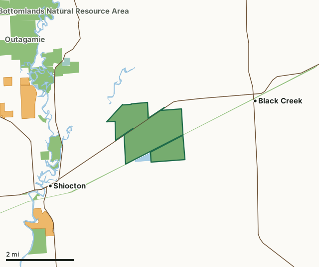
State wildlife areas, forests and other DNR landNational wildlife refuges and waterfowl production areasState parksVoluntary Public Access landMack Wildlife AreaCounty lineLakeHighway
| Size | 1,846 acres in 2 pieces |
|---|---|
| County | Outagamie County |
| Deer Management Unit | Outagamie County |
| DNR lists for hunting | deer |
| Public access (DNR) | Open to Hiking, Fishing, Hunting and Trapping |
| DNR property page | Mack Wildlife Area |
| Nearest towns | Black Creek (2 mi), Shiocton (2 mi) and Nichols (7 mi) |
What is Mack Wildlife Area like?
Mack Wildlife Area is in northcentral Outagamie County. The property is approximately 1,350 acres in size. The Newton-Blackmour state trail bisects the southern section of the wildlife area. Once a glacial lakebed, the area is relatively flat and comprises marsh, aspen, swamp hardwoods, old fields and lowland brush. Soils are muck and a high-water table limits the vegetation types present. The dominant community is aspen. Also, there are bottomland hardwoods of red maple, ash, elm, shrub swamp, fallow fields, and some sedge meadows.
The Wisconsin Conservation Commission purchased all of the Mack Wildlife Area as a single unit in 1943. In the 1950s, share-cropping was conducted on a portion of the property for pheasants. At various times, short-level ditches or potholes were created primarily for wildlife watering holes. Forest succession has since focused management away from pheasants towards other species. The Mack Wildlife Area has currently managed to maintain bottomland hardwoods, aspen, shrub swamp, and grassland areas for wildlife. Find Mack Wildlife Area 2 miles east of Shiocton on Highway 54. There are two parking areas available for the wildlife area located off Herman Road. The Mack Wildlife Area is managed to provide opportunities for public hunting, trapping and other outdoor recreation while protecting the qualities of the native communities and associated species found on the property.
In the DNR's words, from its page for the property.
What can you hunt on Mack Wildlife Area?
The DNR's page for Mack Wildlife Area names deer. Each follows Wisconsin's statewide season and, for deer, the tags and rules of the deer management unit.
What are the rules on Mack Wildlife Area?
The DNR's property map lists Mack Wildlife Area as "Open to Hiking, Fishing, Hunting and Trapping". Hunting follows Wisconsin's statewide seasons and the rules posted on the property.
Activities the DNR lists for Mack Wildlife Area: Birding, Cross-country skiing (no designated trail), Hiking (no designated trail), Hunting (noted for deer), Trapping, Snowmobiling trail and Wild edibles/gathering.
How many deer are taken around Mack Wildlife Area?
Mack Wildlife Area lies in Outagamie County. The DNR registered 4,322 deer in Outagamie County in 2025, against 4,318 in 2024.
| DMU | Mack Wildlife Area acres in it | Deer, 2025 | Deer, 2024 | Deer, 2023 |
|---|---|---|---|---|
| Outagamie County | 1,846 | 4,322 | 4,318 | 3,847 |
Harvest for the whole deer management unit, not the property alone: Wisconsin DNR Deer Metrics (registered harvest by deer management unit).
How do you get to Mack Wildlife Area?
Nearest towns: Black Creek (2 miles), Shiocton (2 miles), Nichols (7 miles) and Seymour (9 miles). Highways within 5 miles: WI 54, WI 47, WI 76 and WI 187. 2 VPA properties within 3 miles.
What other public land is near Mack Wildlife Area?
DNR properties within 10 miles:
- Newton Blackmour State Trail: 286 acres, next to it
- Lower Wolf River Bottomlands Natural Resource Area: 3,670 acres, 1.5 miles away
- Outagamie Wildlife Area: 944 acres, 1.8 miles away
- Wolf River Bottoms Wildlife Area: 3,142 acres, 3.4 miles away
Public land within 3 miles of Mack Wildlife Area
Counting Mack Wildlife Area itself, 2,841 of the 33,834 acres within 3 miles of its boundary are public land open to the public (8.4%), by USGS PAD-US 4.1 (fee land open to the public).
| Manager | Acres within 3 miles |
|---|---|
| State wildlife areas, forests and other DNR land | 2,803 |
| National wildlife refuges and waterfowl production areas | 33 |
| State parks | 5 |
Questions hunters ask
Where is Mack Wildlife Area?
In Outagamie County, 2 miles from Black Creek. The DNR's property page has its maps and parking.
Is Mack Wildlife Area open to hunting?
Yes. The DNR's property map lists it as "Open to Hiking, Fishing, Hunting and Trapping". Posted refuges or closed areas, where there are any, are marked on site.
Which deer management unit is Mack Wildlife Area in?
Outagamie County.
How much public land is around Mack Wildlife Area?
2,841 acres within 3 miles of its boundary, Mack Wildlife Area included, by PAD-US 4.1. The closest other DNR property is Newton Blackmour State Trail (next to it).
Get a Wisconsin hunt plan when they open
Hunt plans for Wisconsin are coming. Join the list and you'll hear first. The first 50 hunters in each new state get their plan free.
Until then, the free FilledTag app for iPhone has a map that works in every state, Wisconsin included.
Where these facts come from
- Area description, species, rules and directions: DNR, Mack Wildlife Area; Wisconsin DNR managed lands open to hunting.
- Boundary and acres: the DNR's map layer above. Surrounding public land: USGS PAD-US 4.1 (fee land open to the public).
- Deer harvest: Wisconsin DNR Deer Metrics (registered harvest by deer management unit).
FilledTag is not part of the Wisconsin Department of Natural Resources. Check the DNR's rules and posted signs before you go.