Outagamie Wildlife Area: hunting and access
Outagamie Wildlife Area is 944 acres of land managed by the Wisconsin DNR in Outagamie County, 2 miles from Shiocton. Hunters registered 4,322 deer in Outagamie County in 2025.
Data updated October 2026. Area facts: the DNR's DNR property data, read 2026-10. Harvest: DNR Deer Metrics.
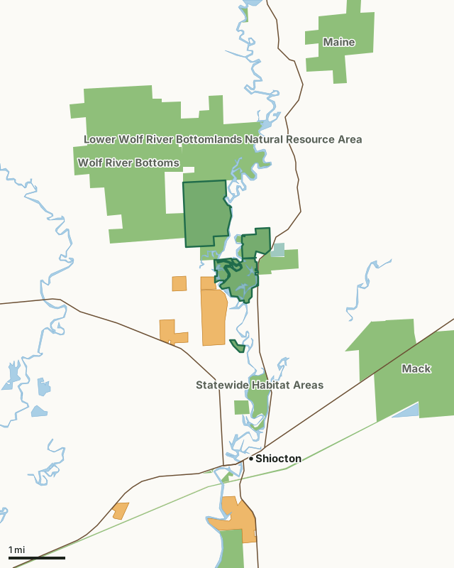
State wildlife areas, forests and other DNR landNational wildlife refuges and waterfowl production areasState parksVoluntary Public Access landOutagamie Wildlife AreaCounty lineLakeHighway
| Size | 944 acres in 6 pieces |
|---|---|
| County | Outagamie County |
| Deer Management Unit | Outagamie County |
| Public access (DNR) | Open to Hiking, Fishing, Hunting and Trapping |
| DNR property page | Outagamie Wildlife Area |
| Nearest towns | Shiocton (2 mi), Black Creek (6 mi) and Nichols (6 mi) |
What is Outagamie Wildlife Area like?
Outagamie Wildlife Area is found in northwest Outagamie County. The state owns approximately 1,000 acres. The property is comprised of bottomland hardwood forest, impounded marsh and aspen forest. The entire wildlife area is located in the Wolf River floodplain. The Wolf River bisects the property allowing excellent access by boat. Outagamie WA started in 1940 as a 412-acre parcel leased from Outagamie County by the Wisconsin Conservation Commission for 20 years for use as public hunting grounds. The lease did not permit any management of the land and, with strong local support from sportsmen’s clubs, the property was purchased in 1958. Additional acreage was acquired later from adjacent landowners. In 1960, a dike was constructed to create a 264-acre flowage. Other short dikes and plugs on old oxbows created another 16 acres of flowage.
Find Outagamie Wildlife Area 4 miles north of Shiocton. There are three parking areas found on the property. Two are located on County Highway M and the other is on Highway 187. The Outagamie Wildlife Area is managed to provide opportunities for public hunting, fishing, trapping and other outdoor recreation while protecting the qualities of the unique native communities and associated species found on the property. Current management objectives in wetland areas include maintaining the bottomland hardwood and swamp hardwood type and maintaining or restoring sedge meadow and emergent marsh. The aspen cover type is maintained were currently found through timber management. The Outagamie Wildlife Area offers many recreational opportunities:.
In the DNR's words, from its page for the property.
What are the rules on Outagamie Wildlife Area?
The DNR's property map lists Outagamie Wildlife Area as "Open to Hiking, Fishing, Hunting and Trapping". Hunting follows Wisconsin's statewide seasons and the rules posted on the property.
Activities the DNR lists for Outagamie Wildlife Area: Birding, Canoeing, Cross-country skiing (no designated trail), Fishing (Wolf River), Hiking (no designated trail), Hunting, Trapping, Wild edibles/gathering and Wildlife viewing.
How many deer are taken around Outagamie Wildlife Area?
Outagamie Wildlife Area lies in Outagamie County. The DNR registered 4,322 deer in Outagamie County in 2025, against 4,318 in 2024.
| DMU | Outagamie Wildlife Area acres in it | Deer, 2025 | Deer, 2024 | Deer, 2023 |
|---|---|---|---|---|
| Outagamie County | 944 | 4,322 | 4,318 | 3,847 |
Harvest for the whole deer management unit, not the property alone: Wisconsin DNR Deer Metrics (registered harvest by deer management unit).
How do you get to Outagamie Wildlife Area?
Nearest towns: Shiocton (2 miles), Black Creek (6 miles), Nichols (6 miles) and Bear Creek (7 miles). Highways within 5 miles: WI 76, WI 54 and WI 187. 2 VPA properties within 3 miles.
What other public land is near Outagamie Wildlife Area?
DNR properties within 10 miles:
- Wolf River Bottoms Wildlife Area: 3,142 acres, next to it
- Lower Wolf River Bottomlands Natural Resource Area: 3,670 acres, next to it
- Mack Wildlife Area: 1,846 acres, 1.8 miles away
- Newton Blackmour State Trail: 286 acres, 2.2 miles away
Public land within 3 miles of Outagamie Wildlife Area
Counting Outagamie Wildlife Area itself, 6,149 of the 34,181 acres within 3 miles of its boundary are public land open to the public (18%), by USGS PAD-US 4.1 (fee land open to the public).
| Manager | Acres within 3 miles |
|---|---|
| State wildlife areas, forests and other DNR land | 6,113 |
| National wildlife refuges and waterfowl production areas | 33 |
| State parks | 3 |
Questions hunters ask
Where is Outagamie Wildlife Area?
In Outagamie County, 2 miles from Shiocton. The DNR's property page has its maps and parking.
Is Outagamie Wildlife Area open to hunting?
Yes. The DNR's property map lists it as "Open to Hiking, Fishing, Hunting and Trapping". Posted refuges or closed areas, where there are any, are marked on site.
Which deer management unit is Outagamie Wildlife Area in?
Outagamie County.
How much public land is around Outagamie Wildlife Area?
6,149 acres within 3 miles of its boundary, Outagamie Wildlife Area included, by PAD-US 4.1. The closest other DNR property is Wolf River Bottoms Wildlife Area (next to it).
Get a Wisconsin hunt plan when they open
Hunt plans for Wisconsin are coming. Join the list and you'll hear first. The first 50 hunters in each new state get their plan free.
Until then, the free FilledTag app for iPhone has a map that works in every state, Wisconsin included.
Where these facts come from
- Area description, species, rules and directions: DNR, Outagamie Wildlife Area; Wisconsin DNR managed lands open to hunting.
- Boundary and acres: the DNR's map layer above. Surrounding public land: USGS PAD-US 4.1 (fee land open to the public).
- Deer harvest: Wisconsin DNR Deer Metrics (registered harvest by deer management unit).
FilledTag is not part of the Wisconsin Department of Natural Resources. Check the DNR's rules and posted signs before you go.