Mount Vernon Creek Fishery Area: hunting and access
Mount Vernon Creek Fishery Area is 406 acres of land managed by the Wisconsin DNR in Dane County, 5 miles from Mount Horeb. The DNR's page for it names pheasants among the game here. Hunters registered 4,438 deer in Dane County in 2025.
Data updated October 2026. Area facts: the DNR's DNR property data, read 2026-10. Harvest: DNR Deer Metrics.
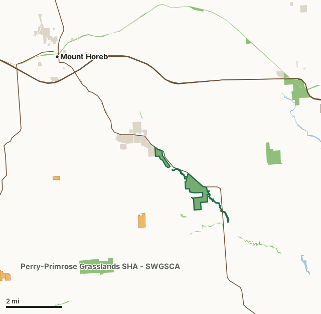
State wildlife areas, forests and other DNR landState parksOther county, city and regional landLand trusts and other open landVoluntary Public Access landMount Vernon Creek Fishery AreaCounty lineLakeHighway
| Size | 406 acres in 5 pieces |
|---|---|
| County | Dane County |
| Deer Management Unit | Dane County |
| DNR lists for hunting | pheasants |
| Public access (DNR) | Open to Hiking, Fishing, Hunting and Trapping |
| DNR property page | Mount Vernon Creek Fishery Area |
| Nearest towns | Mount Horeb (5 mi), Belleville (5 mi) and Verona (6 mi) |
What is Mount Vernon Creek Fishery Area like?
Uplands consist of oak woods and a few remnant prairies. These grasslands are old pasture converting back to original vegetation. There are planted prairie grass fields and a newly planted tree pine plantation site that harbors nursing oak. The rolling area hills give the property the charm of diverse topography. A well-known spring sits on the northwestern parcel of the property. There is an observation platform that Dane County has graciously built with the help of the Friends of Donald Park. In the 1800s the pioneers used the spring. Later family groups came out by horse and buggy from Mount Horeb to picnic next to the cool spring.
Dane County and the Friends of Donald Park helped build the observation platform over the old spring and individual members of the volunteer group continue to help steward the northern parcel. These acres along with the eastern parcel have also seen countless efforts by individual members from the Deer Creek Sportsmen's Club. This property is broken into two main parcels in Dane County. Forty-nine acres sit on the northwest corner of the town of Mount Vernon along the southern side of Highway 82 leading into town. Another 286 acres abut Highway 92 and begin just after you exit Mount Vernon on the northeast side of town. This property harbors one of DNR's most famous restored trout streams in Wisconsin.
In the DNR's words, from its page for the property.
What can you hunt on Mount Vernon Creek Fishery Area?
The DNR's page for Mount Vernon Creek Fishery Area names pheasants. Each follows Wisconsin's statewide season and, for deer, the tags and rules of the deer management unit.
What are the rules on Mount Vernon Creek Fishery Area?
The DNR's property map lists Mount Vernon Creek Fishery Area as "Open to Hiking, Fishing, Hunting and Trapping". Hunting follows Wisconsin's statewide seasons and the rules posted on the property.
Activities the DNR lists for Mount Vernon Creek Fishery Area: Hunting - not stocked for pheasants, Trapping, Hiking, Snowmobiling trail and Geocaching (with property manager approval).
How many deer are taken around Mount Vernon Creek Fishery Area?
Mount Vernon Creek Fishery Area lies in Dane County. The DNR registered 4,438 deer in Dane County in 2025, against 4,403 in 2024.
| DMU | Mount Vernon Creek Fishery Area acres in it | Deer, 2025 | Deer, 2024 | Deer, 2023 |
|---|---|---|---|---|
| Dane County | 406 | 4,438 | 4,403 | 4,461 |
Harvest for the whole deer management unit, not the property alone: Wisconsin DNR Deer Metrics (registered harvest by deer management unit).
How do you get to Mount Vernon Creek Fishery Area?
Nearest towns: Mount Horeb (5 miles), Belleville (5 miles), Verona (6 miles) and New Glarus (7 miles). Highways within 5 miles: US 151, US 18, WI 92, WI 69 and WI 78. 1 VPA property within 3 miles.
What other public land is near Mount Vernon Creek Fishery Area?
DNR properties within 10 miles:
- West Branch Little Sugar River SBE Area: 125 acres, 0.6 miles away
- Olson Oak Woods State Natural Area: 20 acres, 2.5 miles away
- Perry-Primrose Grasslands SHA - SWGSCA: 352 acres, 3.4 miles away
- Sugar River Wetlands State Natural Area: 261 acres, 4.3 miles away
Public land within 3 miles of Mount Vernon Creek Fishery Area
Counting Mount Vernon Creek Fishery Area itself, 1,092 of the 34,131 acres within 3 miles of its boundary are public land open to the public (3.2%), by USGS PAD-US 4.1 (fee land open to the public).
| Manager | Acres within 3 miles |
|---|---|
| State wildlife areas, forests and other DNR land | 670 |
| Other county, city and regional land | 421 |
| Land trusts and other open land | 1 |
Questions hunters ask
Where is Mount Vernon Creek Fishery Area?
In Dane County, 5 miles from Mount Horeb. The DNR's property page has its maps and parking.
Is Mount Vernon Creek Fishery Area open to hunting?
Yes. The DNR's property map lists it as "Open to Hiking, Fishing, Hunting and Trapping". Posted refuges or closed areas, where there are any, are marked on site.
Which deer management unit is Mount Vernon Creek Fishery Area in?
Dane County.
How much public land is around Mount Vernon Creek Fishery Area?
1,092 acres within 3 miles of its boundary, Mount Vernon Creek Fishery Area included, by PAD-US 4.1. The closest other DNR property is West Branch Little Sugar River SBE Area (0.6 miles).
Get a Wisconsin hunt plan when they open
Hunt plans for Wisconsin are coming. Join the list and you'll hear first. The first 50 hunters in each new state get their plan free.
Until then, the free FilledTag app for iPhone has a map that works in every state, Wisconsin included.
Where these facts come from
- Area description, species, rules and directions: DNR, Mount Vernon Creek Fishery Area; Wisconsin DNR managed lands open to hunting.
- Boundary and acres: the DNR's map layer above. Surrounding public land: USGS PAD-US 4.1 (fee land open to the public).
- Deer harvest: Wisconsin DNR Deer Metrics (registered harvest by deer management unit).
FilledTag is not part of the Wisconsin Department of Natural Resources. Check the DNR's rules and posted signs before you go.