Sugar River Wetlands State Natural Area: hunting and access
Sugar River Wetlands State Natural Area is 261 acres of land managed by the Wisconsin DNR in Dane County, next to Verona. Hunters registered 4,438 deer in Dane County in 2025.
Data updated October 2026. Area facts: the DNR's DNR property data, read 2026-10. Harvest: DNR Deer Metrics.
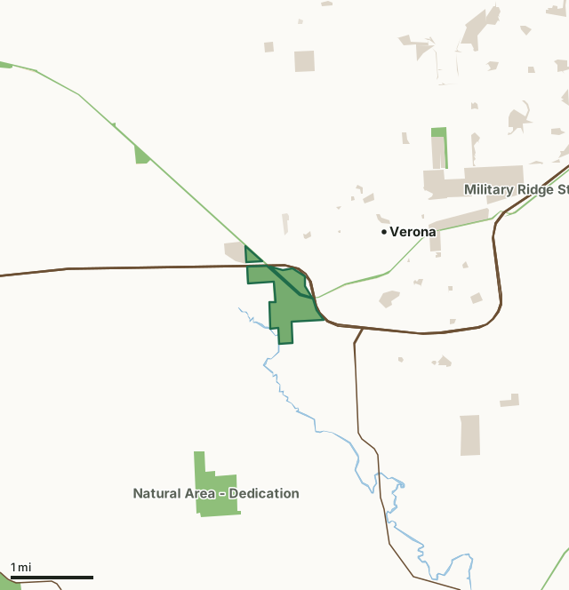
State wildlife areas, forests and other DNR landState parksOther county, city and regional landLand trusts and other open landSugar River Wetlands State Natural AreaCounty lineLakeHighway
| Size | 261 acres in 3 pieces |
|---|---|
| County | Dane County |
| Deer Management Unit | Dane County |
| Public access (DNR) | Open to Hiking, Fishing, Hunting and Trapping |
| DNR property page | Sugar River Wetlands |
| Nearest towns | Verona (next to it), Fitchburg (7 mi) and Belleville (8 mi) |
What is Sugar River Wetlands State Natural Area like?
Sugar River Wetlands features a diverse wetland complex including a sedge meadow, calcareous fen, emergent aquatic, shrub-carr, and wet-mesic prairie. Located within the Upper Sugar River Watershed, this extensive wetland harbors numerous rare plant and animal species and contains the most diverse fishery in southern Wisconsin. The fen flora is diverse with many calcium-loving plants including Kalm's lobelia, grass-of-Parnassus, and shrubby cinquefoil. The carbonate-rich groundwater that percolates up from the underlying bedrock provides high-quality water to the surrounding wetlands and rivers. Intergrading with the fen is a wet-mesic prairie dominated by tall grasses including big blue-stem, Canada blue-joint grass, prairie cord grass, and Canada wild rye. The forb component is diverse with azure aster, shooting star, prairie blazing star, prairie phlox, and culver's root.
Dane County. T6N-R8E, Sections 17, 20, 21. 266 acres. Access via the Military Ridge Bike Trail. For walk-in access: From the intersection of U.S. Highway 18 and County Highway MV (Business 18) in Verona, go east on MV about 0.3 miles, then north on Country View Road about one mile to a gated access lane. Park and walk south on the access road, then go southeast on the recreational trail into the site. For bike access: Park in the lot on County Highway PB just south of County MV and ride southwest into the area. Or from the intersection of Highway 69 and County M, go south on 69 for 1.1 miles, then west on Valley Road for 0.9 miles to a DNR parking area north of the road.
In the DNR's words, from its page for the property.
What are the rules on Sugar River Wetlands State Natural Area?
The DNR's property map lists Sugar River Wetlands State Natural Area as "Open to Hiking, Fishing, Hunting and Trapping". Hunting follows Wisconsin's statewide seasons and the rules posted on the property.
How many deer are taken around Sugar River Wetlands State Natural Area?
Sugar River Wetlands State Natural Area lies in Dane County. The DNR registered 4,438 deer in Dane County in 2025, against 4,403 in 2024.
| DMU | Sugar River Wetlands State Natural Area acres in it | Deer, 2025 | Deer, 2024 | Deer, 2023 |
|---|---|---|---|---|
| Dane County | 261 | 4,438 | 4,403 | 4,461 |
Harvest for the whole deer management unit, not the property alone: Wisconsin DNR Deer Metrics (registered harvest by deer management unit).
How do you get to Sugar River Wetlands State Natural Area?
Nearest towns: Verona (next to it), Fitchburg (7 miles), Belleville (8 miles) and Mount Horeb (8 miles). Highways within 5 miles: US 151, US 18, WI 69 and WI 92.
What other public land is near Sugar River Wetlands State Natural Area?
DNR properties within 10 miles:
- Military Ridge State Trail: 519 acres, next to it
- Olson Oak Woods State Natural Area: 20 acres, 1.6 miles away
- State Ice Age Trail Area (SIATA): 4,676 acres, 2.2 miles away
- Badger State Trail: 523 acres, 4.1 miles away
- Mount Vernon Creek Fishery Area: 406 acres, 4.3 miles away
- West Branch Little Sugar River SBE Area: 125 acres, 5.1 miles away
Public land within 3 miles of Sugar River Wetlands State Natural Area
Counting Sugar River Wetlands State Natural Area itself, 1,223 of the 24,811 acres within 3 miles of its boundary are public land open to the public (4.9%), by USGS PAD-US 4.1 (fee land open to the public).
| Manager | Acres within 3 miles |
|---|---|
| Other county, city and regional land | 629 |
| State wildlife areas, forests and other DNR land | 575 |
| Land trusts and other open land | 10 |
| State parks | 9 |
Questions hunters ask
Where is Sugar River Wetlands State Natural Area?
In Dane County, next to Verona. The DNR's property page has its maps and parking.
Is Sugar River Wetlands State Natural Area open to hunting?
Yes. The DNR's property map lists it as "Open to Hiking, Fishing, Hunting and Trapping". Posted refuges or closed areas, where there are any, are marked on site.
Which deer management unit is Sugar River Wetlands State Natural Area in?
Dane County.
How much public land is around Sugar River Wetlands State Natural Area?
1,223 acres within 3 miles of its boundary, Sugar River Wetlands State Natural Area included, by PAD-US 4.1. The closest other DNR property is Military Ridge State Trail (next to it).
Get a Wisconsin hunt plan when they open
Hunt plans for Wisconsin are coming. Join the list and you'll hear first. The first 50 hunters in each new state get their plan free.
Until then, the free FilledTag app for iPhone has a map that works in every state, Wisconsin included.
Where these facts come from
- Area description, species, rules and directions: DNR, Sugar River Wetlands State Natural Area; Wisconsin DNR managed lands open to hunting.
- Boundary and acres: the DNR's map layer above. Surrounding public land: USGS PAD-US 4.1 (fee land open to the public).
- Deer harvest: Wisconsin DNR Deer Metrics (registered harvest by deer management unit).
FilledTag is not part of the Wisconsin Department of Natural Resources. Check the DNR's rules and posted signs before you go.