Muddy Creek Wildlife Area: hunting and access
Muddy Creek Wildlife Area is 3,795 acres of land managed by the Wisconsin DNR in Dunn County, 2 miles from Elk Mound. The DNR's page for it names deer, wild turkey, pheasants, ducks and geese and small game among the game here. Hunters registered 9,118 deer in Dunn County in 2025.
Data updated October 2026. Area facts: the DNR's DNR property data, read 2026-10. Harvest: DNR Deer Metrics.
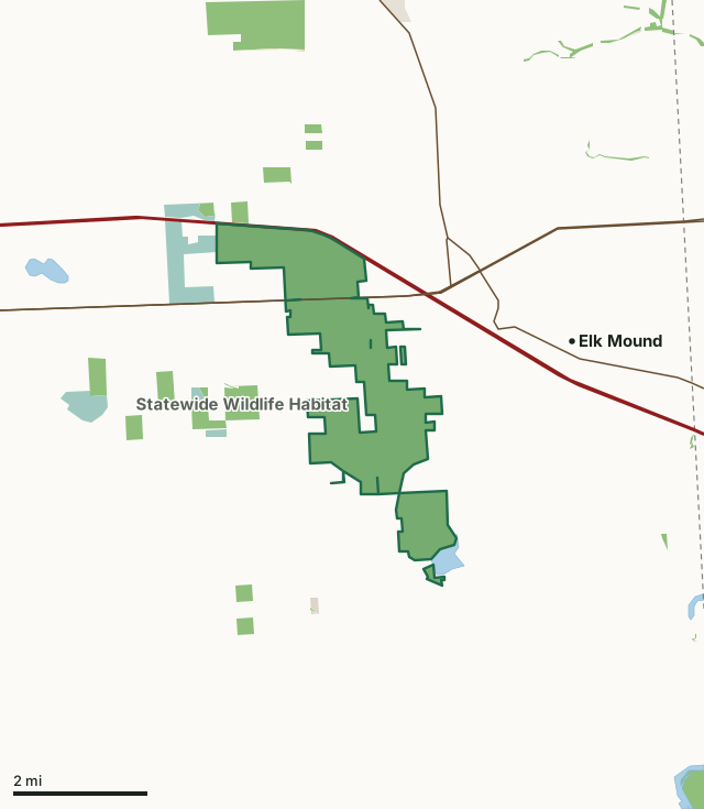
State wildlife areas, forests and other DNR landNational wildlife refuges and waterfowl production areasState parksOther county, city and regional landLand trusts and other open landMuddy Creek Wildlife AreaCounty lineLakeHighway
| Size | 3,795 acres in 4 pieces |
|---|---|
| County | Dunn County |
| Deer Management Unit | Dunn County |
| DNR lists for hunting | deer, wild turkey, pheasants, ducks and geese and small game |
| Public access (DNR) | Open to Hiking, Fishing, Hunting and Trapping |
| DNR property page | Muddy Creek Wildlife Area |
| Nearest towns | Elk Mound (2 mi), Menomonie (6 mi) and Tainter Lake (7 mi) |
What is Muddy Creek Wildlife Area like?
Muddy Creek and the associated marsh and sedge meadow are the predominant features of this property. Within this marshy landscape are numerous "islands" that are either wooded or prairie. The periphery of the property, including the scattered parcels, are predominantly former farm fields that have been converted to warm season, tallgrass prairies. Numerous restored wetlands also exist within this group of properties. A small percentage of the property is wooded with a great deal of species diversity, including white pine, red and white oak and aspen. The Muddy Creek Sedge Meadow State Natural Area has been established on the south end of the property to recognize the 195-acre sedge meadow that occupies this portion of the wildlife area.
In addition, lying just to the south of the wildlife area is the 200-plus-acre Old Elk Lake. This shallow lake is fed by runoff and springs and is reminiscent of the prairie pothole lakes found in the Dakotas. This is a rare water resource in this part of Wisconsin that provides tremendous waterfowl production and valuable hunting and trapping opportunities. There is DNR ownership around part of the lake with carry-in access possible from a parking lot on County Highway E. Muddy Creek Wildlife Area was officially established in 1969. At that time, nearly 1,400 acres were already protected through state ownership. Several attempts by landowners to drain the marsh were evident by the 10,000-plus linear feet of ditches that were present throughout the marsh. Beaver took full advantage of these ditches, creating numerous impoundments. Adjacent farmland was considered marginal at best.
In the DNR's words, from its page for the property.
What can you hunt on Muddy Creek Wildlife Area?
The DNR's page for Muddy Creek Wildlife Area names deer, wild turkey, pheasants, ducks and geese and small game. Each follows Wisconsin's statewide season and, for deer, the tags and rules of the deer management unit.
What are the rules on Muddy Creek Wildlife Area?
The DNR's property map lists Muddy Creek Wildlife Area as "Open to Hiking, Fishing, Hunting and Trapping". Hunting follows Wisconsin's statewide seasons and the rules posted on the property.
Activities the DNR lists for Muddy Creek Wildlife Area: Birding, Boating (non-motorized carry-in only), Canoeing (Old Elk Lake), Kayaking (Old Elk Lake), Cross-country skiing (no designated trail), Fishing, Hiking (no designated trail), Hunting (especially noted for deer, turkey, pheasant, waterfowl and small game), Trapping, Wild edibles/gathering and Wildlife viewing.
How many deer are taken around Muddy Creek Wildlife Area?
Muddy Creek Wildlife Area lies in Dunn County. The DNR registered 9,118 deer in Dunn County in 2025, against 7,819 in 2024.
| DMU | Muddy Creek Wildlife Area acres in it | Deer, 2025 | Deer, 2024 | Deer, 2023 |
|---|---|---|---|---|
| Dunn County | 3,795 | 9,118 | 7,819 | 6,979 |
Harvest for the whole deer management unit, not the property alone: Wisconsin DNR Deer Metrics (registered harvest by deer management unit).
How do you get to Muddy Creek Wildlife Area?
Nearest towns: Elk Mound (2 miles), Menomonie (6 miles), Tainter Lake (7 miles) and Colfax (7 miles). Highways within 5 miles: I-94, WI 29, US 12, WI 40 and WI 12.
What other public land is near Muddy Creek Wildlife Area?
DNR properties within 10 miles:
- Hoffman Hills Recreation Area: 715 acres, 2.6 miles away
- Elk Creek Fishery Area: 504 acres, 3.1 miles away
Public land within 3 miles of Muddy Creek Wildlife Area
Counting Muddy Creek Wildlife Area itself, 5,413 of the 51,447 acres within 3 miles of its boundary are public land open to the public (10.5%), by USGS PAD-US 4.1 (fee land open to the public).
| Manager | Acres within 3 miles |
|---|---|
| State wildlife areas, forests and other DNR land | 4,830 |
| National wildlife refuges and waterfowl production areas | 562 |
| Other county, city and regional land | 17 |
| State parks | 4 |
Questions hunters ask
Where is Muddy Creek Wildlife Area?
In Dunn County, 2 miles from Elk Mound. The DNR's property page has its maps and parking.
Is Muddy Creek Wildlife Area open to hunting?
Yes. The DNR's property map lists it as "Open to Hiking, Fishing, Hunting and Trapping". Posted refuges or closed areas, where there are any, are marked on site.
Which deer management unit is Muddy Creek Wildlife Area in?
Dunn County.
How much public land is around Muddy Creek Wildlife Area?
5,413 acres within 3 miles of its boundary, Muddy Creek Wildlife Area included, by PAD-US 4.1. The closest other DNR property is Hoffman Hills Recreation Area (2.6 miles).
Get a Wisconsin hunt plan when they open
Hunt plans for Wisconsin are coming. Join the list and you'll hear first. The first 50 hunters in each new state get their plan free.
Until then, the free FilledTag app for iPhone has a map that works in every state, Wisconsin included.
Where these facts come from
- Area description, species, rules and directions: DNR, Muddy Creek Wildlife Area; Wisconsin DNR managed lands open to hunting.
- Boundary and acres: the DNR's map layer above. Surrounding public land: USGS PAD-US 4.1 (fee land open to the public).
- Deer harvest: Wisconsin DNR Deer Metrics (registered harvest by deer management unit).
FilledTag is not part of the Wisconsin Department of Natural Resources. Check the DNR's rules and posted signs before you go.