Myklebust Lake State Natural Area: hunting and access
Myklebust Lake State Natural Area is 171 acres of land managed by the Wisconsin DNR in Waupaca County, next to Iola. Hunters registered 10,740 deer in Waupaca County in 2025.
Data updated October 2026. Area facts: the DNR's DNR property data, read 2026-10. Harvest: DNR Deer Metrics.
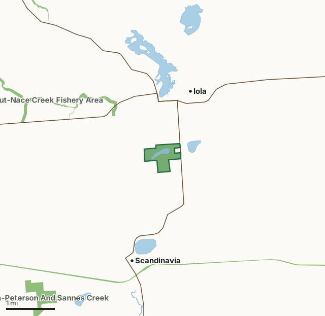
State wildlife areas, forests and other DNR landOther federal landState parksMyklebust Lake State Natural AreaCounty lineLakeHighway
| Size | 171 acres |
|---|---|
| County | Waupaca County |
| Deer Management Unit | Waupaca County |
| Public access (DNR) | Open to Hiking, Fishing, Hunting and Trapping |
| DNR property page | Myklebust Lake |
| Nearest towns | Iola (next to it), Scandinavia (2 mi) and Ogdensburg (5 mi) |
What is Myklebust Lake State Natural Area like?
Mykelbust Lake features a deep, 20-acre marl-bottomed lake with an undeveloped shoreline and exceptionally clear water provided by numerous springs. A narrow wetland fringe of bur-reed and hard-stemmed bulrush surrounds the lake and along the one-half-mile outlet stream which flows into the South Branch of the Little Wolf River. Wild celery and water star grass inhabit the high quality, swift current of the outlet and the macro-algae Chara is abundant on the lake bottom. The lake’s macrophyte community is diverse and contains emergent aquatics such as white water-lily, bull-head pond-lily, arrowhead, flowering rush, wild rice, seven-angle pipewort, quillwort and several pondweeds.
A 2-acre black spruce bog is found in the southeast corner while the east shore contains a small stand of large white pine, some more than two feet in diameter. The remainder of the uplands is a mixture of second-growth northern hardwoods. The lake supports an excellent northern pike, largemouth bass, and panfish fishery. Teal and wood ducks frequent the stream. Myklebust Lake is owned by the DNR and was designated a State Natural Area in 1982. Waupaca County. T23N-R11E, Sections 2, 11. 170 acres. From the junction of State Highways 161 and 49 in Iola, go south on 49 for 1.1 miles to a parking area west of the road. Walk west along an access lane to a carry-in canoe landing.
In the DNR's words, from its page for the property.
What are the rules on Myklebust Lake State Natural Area?
The DNR's property map lists Myklebust Lake State Natural Area as "Open to Hiking, Fishing, Hunting and Trapping". Hunting follows Wisconsin's statewide seasons and the rules posted on the property.
How many deer are taken around Myklebust Lake State Natural Area?
Myklebust Lake State Natural Area lies in Waupaca County. The DNR registered 10,740 deer in Waupaca County in 2025, against 10,349 in 2024.
| DMU | Myklebust Lake State Natural Area acres in it | Deer, 2025 | Deer, 2024 | Deer, 2023 |
|---|---|---|---|---|
| Waupaca County | 171 | 10,740 | 10,349 | 9,097 |
Harvest for the whole deer management unit, not the property alone: Wisconsin DNR Deer Metrics (registered harvest by deer management unit).
How do you get to Myklebust Lake State Natural Area?
Nearest towns: Iola (next to it), Scandinavia (2 miles), Ogdensburg (5 miles) and Amherst (8 miles). Highways within 5 miles: WI 49 and WI 161.
What other public land is near Myklebust Lake State Natural Area?
DNR properties within 10 miles:
- Trout-Nace Creek Fishery Area: 169 acres, 0.9 miles away
- Tomorrow River State Trail: 376 acres, 1.9 miles away
- State Ice Age Trail Area (SIATA): 4,676 acres, 5.3 miles away
- Skunk And Foster Lakes State Natural Area: 265 acres, 5.3 miles away
Public land within 3 miles of Myklebust Lake State Natural Area
Counting Myklebust Lake State Natural Area itself, 340 of the 22,635 acres within 3 miles of its boundary are public land open to the public (1.5%), by USGS PAD-US 4.1 (fee land open to the public).
| Manager | Acres within 3 miles |
|---|---|
| State wildlife areas, forests and other DNR land | 335 |
| State parks | 2 |
| Land trusts and other open land | 2 |
| Other federal land | 1 |
Questions hunters ask
Where is Myklebust Lake State Natural Area?
In Waupaca County, next to Iola. The DNR's property page has its maps and parking.
Is Myklebust Lake State Natural Area open to hunting?
Yes. The DNR's property map lists it as "Open to Hiking, Fishing, Hunting and Trapping". Posted refuges or closed areas, where there are any, are marked on site.
Which deer management unit is Myklebust Lake State Natural Area in?
Waupaca County.
How much public land is around Myklebust Lake State Natural Area?
340 acres within 3 miles of its boundary, Myklebust Lake State Natural Area included, by PAD-US 4.1. The closest other DNR property is Trout-Nace Creek Fishery Area (0.9 miles).
Get a Wisconsin hunt plan when they open
Hunt plans for Wisconsin are coming. Join the list and you'll hear first. The first 50 hunters in each new state get their plan free.
Until then, the free FilledTag app for iPhone has a map that works in every state, Wisconsin included.
Where these facts come from
- Area description, species, rules and directions: DNR, Myklebust Lake State Natural Area; Wisconsin DNR managed lands open to hunting.
- Boundary and acres: the DNR's map layer above. Surrounding public land: USGS PAD-US 4.1 (fee land open to the public).
- Deer harvest: Wisconsin DNR Deer Metrics (registered harvest by deer management unit).
FilledTag is not part of the Wisconsin Department of Natural Resources. Check the DNR's rules and posted signs before you go.