N Branch Milwaukee River WA and FHA: hunting and access
N Branch Milwaukee River WA and FHA is 1,115 acres of land managed by the Wisconsin DNR in Ozaukee, Sheboygan and Washington counties, next to Random Lake. The DNR's page for it names ducks and geese among the game here. Hunters registered 1,284 deer in Ozaukee County in 2025.
Data updated October 2026. Area facts: the DNR's DNR property data, read 2026-10. Harvest: DNR Deer Metrics.
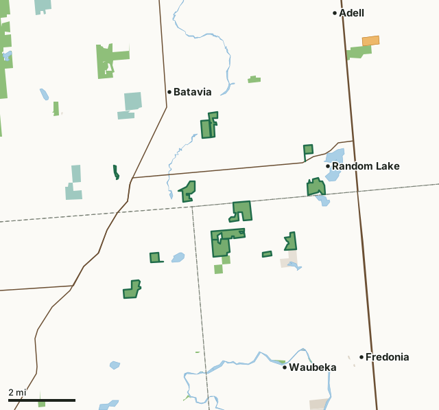
State wildlife areas, forests and other DNR landNational wildlife refuges and waterfowl production areasOther federal landOther county, city and regional landLand trusts and other open landVoluntary Public Access landN Branch Milwaukee River WA and FHACounty lineLakeHighway
| Size | 1,115 acres in 12 pieces |
|---|---|
| Counties | Ozaukee County, Sheboygan County and Washington County |
| Deer Management Unit | Ozaukee County, Sheboygan County, Washington County |
| DNR lists for hunting | ducks and geese |
| Public access (DNR) | Open to Hiking, Fishing, Hunting and Trapping |
| DNR property page | North Branch Milwaukee River Wildlife and Farming Heritage Area |
| Nearest towns | Random Lake (next to it), Batavia (next to it) and Waubeka (3 mi) |
What is N Branch Milwaukee River WA and FHA like?
North Branch Milwaukee River Wildlife and Farming Heritage Area is within 20 miles of the Milwaukee metropolitian area and lies within the Milwaukee River Basin in northwestern Ozaukee, southwestern Sheboygan and northeastern Washington counties. Scattered parcels of public land lie within a 25-square-mile block of land southwest of the village of Random Lake and northwest of Fredonia - both villages are along state Highway 57. This is a new and active acquisition project that, as of 2009, included 13 parcels of state owned-land totaling 765 acres and two privately owned properties - totaling 171 acres - with easements that allow for public use.
This project area is one of the largest blocks on undeveloped land in southeastern Wisconsin yet within 20 miles of the Milwaukee metropolitan area. Although located just outside of the largest urban area in the state, the project area is predominantly open and rural with large wetland complexes, riparian corridors and agriculture dominating the landscape. The project area includes 9 miles of the North Branch Milwaukee River and five tributary streams, expansive areas of floodplain forest, coniferous swamps, other wetlands, three small lakes and large blocks of agricultural lands. Because of its location and natural resource features, the property has the potential for preserving farmland or "stabilizing the rural landscape" while providing low impact, nature-based, outdoor recreational opportunities.
In the DNR's words, from its page for the property.
What can you hunt on N Branch Milwaukee River WA and FHA?
The DNR's page for N Branch Milwaukee River WA and FHA names ducks and geese. Each follows Wisconsin's statewide season and, for deer, the tags and rules of the deer management unit.
What are the rules on N Branch Milwaukee River WA and FHA?
The DNR's property map lists N Branch Milwaukee River WA and FHA as "Open to Hiking, Fishing, Hunting and Trapping". Hunting follows Wisconsin's statewide seasons and the rules posted on the property.
Activities the DNR lists for N Branch Milwaukee River WA and FHA: Birding;, Canoeing;, Cross-country skiing (no designated trail);, Fishing;, Hiking (no designated trail);, Hunting;, Snowmobiling trail;, Trapping;, Wild edibles/gathering; and and Wildlife viewing.
How many deer are taken around N Branch Milwaukee River WA and FHA?
N Branch Milwaukee River WA and FHA lies in 3 deer management units. The DNR registered 1,284 deer in Ozaukee County in 2025, against 1,235 in 2024.
| DMU | N Branch Milwaukee River WA and FHA acres in it | Deer, 2025 | Deer, 2024 | Deer, 2023 |
|---|---|---|---|---|
| Ozaukee County | 549 | 1,284 | 1,235 | 1,237 |
| Sheboygan County | 423 | 3,562 | 3,536 | 3,251 |
| Washington County | 142 | 3,731 | 3,427 | 2,972 |
Harvest for the whole deer management unit, not the property alone: Wisconsin DNR Deer Metrics (registered harvest by deer management unit).
How do you get to N Branch Milwaukee River WA and FHA?
Nearest towns: Random Lake (next to it), Batavia (next to it), Waubeka (3 miles) and Fredonia (4 miles). Highways within 5 miles: WI 57, WI 144 and WI 28.
What other public land is near N Branch Milwaukee River WA and FHA?
DNR properties within 10 miles:
- Kettle Moraine State Forest-Northern Unit: 30,281 acres, 3.5 miles away
- Lizard Mound State Park: 33 acres, 3.7 miles away
- Lake Ellen Public Access: 40 acres, 4.4 miles away
Public land within 3 miles of N Branch Milwaukee River WA and FHA
Counting N Branch Milwaukee River WA and FHA itself, 1,992 of the 68,999 acres within 3 miles of its boundary are public land open to the public (2.9%), by USGS PAD-US 4.1 (fee land open to the public).
| Manager | Acres within 3 miles |
|---|---|
| State wildlife areas, forests and other DNR land | 1,443 |
| National wildlife refuges and waterfowl production areas | 424 |
| Land trusts and other open land | 123 |
| Other federal land | 2 |
Questions hunters ask
Where is N Branch Milwaukee River WA and FHA?
In Ozaukee, Sheboygan and Washington counties, next to Random Lake. The DNR's property page has its maps and parking.
Is N Branch Milwaukee River WA and FHA open to hunting?
Yes. The DNR's property map lists it as "Open to Hiking, Fishing, Hunting and Trapping". Posted refuges or closed areas, where there are any, are marked on site.
Which deer management unit is N Branch Milwaukee River WA and FHA in?
Ozaukee County (549 acres), Sheboygan County (423 acres) and Washington County (142 acres).
How much public land is around N Branch Milwaukee River WA and FHA?
1,992 acres within 3 miles of its boundary, N Branch Milwaukee River WA and FHA included, by PAD-US 4.1. The closest other DNR property is Kettle Moraine State Forest-Northern Unit (3.5 miles).
Get a Wisconsin hunt plan when they open
Hunt plans for Wisconsin are coming. Join the list and you'll hear first. The first 50 hunters in each new state get their plan free.
Until then, the free FilledTag app for iPhone has a map that works in every state, Wisconsin included.
Where these facts come from
- Area description, species, rules and directions: DNR, N Branch Milwaukee River WA and FHA; Wisconsin DNR managed lands open to hunting.
- Boundary and acres: the DNR's map layer above. Surrounding public land: USGS PAD-US 4.1 (fee land open to the public).
- Deer harvest: Wisconsin DNR Deer Metrics (registered harvest by deer management unit).
FilledTag is not part of the Wisconsin Department of Natural Resources. Check the DNR's rules and posted signs before you go.
Wisconsin hunting Ozaukee County Sheboygan County Washington County Ozaukee County Sheboygan County Washington County