Namekagon Barrens Wildlife Area: hunting and access
Namekagon Barrens Wildlife Area is 6,434 acres of land managed by the Wisconsin DNR in Burnett, Washburn and Douglas counties, 10 miles from Minong. The DNR's page for it names wild turkey and ruffed grouse among the game here. Hunters registered 2,406 deer in DMU 107 in 2025.
Data updated October 2026. Area facts: the DNR's DNR property data, read 2026-10. Harvest: DNR Deer Metrics.
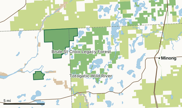
State wildlife areas, forests and other DNR landCounty forestNational park landNamekagon Barrens Wildlife AreaCounty lineLakeHighway
| Size | 6,434 acres in 2 pieces |
|---|---|
| Counties | Burnett County, Washburn County and Douglas County |
| Deer Management Unit | DMU 107 |
| DNR lists for hunting | wild turkey and ruffed grouse |
| Public access (DNR) | Open to Hiking, Fishing, Hunting and Trapping |
| DNR property page | Namekagon Barrens Wildlife Area |
| Nearest towns | Minong (10 mi), Danbury (12 mi) and Gordon (12 mi) |
What is Namekagon Barrens Wildlife Area like?
This is a must-see, globally rare habitat. Come see all the wildlife species this open-landscape habitat attracts. The Namekagon Barrens Wildlife Area is a uniquely beautiful 6,446-acre property located at the junction of the northern parts of Burnett and Washburn counties, consisting of two units separated by a few miles. As part of the Northwest Sands Ecological Landscape of northwest Wisconsin, it is characterized by sandy soils and a pine/oak barrens community rich with diverse prairie flora and fauna. The North Unit is 5,663 acres with a big open sky that's perfect for listening to wolves while stargazing or seeing the big, beautiful, fluffy clouds while hiking easy terrain alongside native grasses, flowers and shrubs. The South Unit is 753 acres of rolling terrain that is often referred to as “Little Montana”.
It's also a favorite hunting destination for locally high populations of turkeys, deer and bears. Hunters enjoy the open landscape and wilderness experience. The possibility of a sharp-tailed grouse hunt is determined annually. Visit the Sharp-tailed grouse hunting webpage for the most up-to-date information. In 2015, the state acquired fee title of the land previously leased (approximately 5,000 acres) through a land trade with Burnett County. The land in the barrens area was settled in the early 1900s, but went tax delinquent and reverted to Burnett County in the 1930s due to the dry sandy soils, drought, and the Depression. The Friends of Namekagon Barrens Wildlife Area (FNBWA) was established in the mid-1950s through a lease with Burnett County out of concern for the rapidly declining prairie grouse species in Wisconsin.
In the DNR's words, from its page for the property.
What can you hunt on Namekagon Barrens Wildlife Area?
The DNR's page for Namekagon Barrens Wildlife Area names wild turkey and ruffed grouse. Each follows Wisconsin's statewide season and, for deer, the tags and rules of the deer management unit.
What are the rules on Namekagon Barrens Wildlife Area?
The DNR's property map lists Namekagon Barrens Wildlife Area as "Open to Hiking, Fishing, Hunting and Trapping". Hunting follows Wisconsin's statewide seasons and the rules posted on the property.
Activities the DNR lists for Namekagon Barrens Wildlife Area: ATV trail (only on town road trail system, no ATVs allowed on the property), Auto travel (only on town roads), Birding (sharp-tailed grouse viewing opportunities, upland sandpipers, and other rare grassland birds), Camping (by permit on county forests), Canoeing (available nearby on Namekagon and Totogatic rivers), Cross-country skiing and snowshoeing (no designated trails, lots of off-trail cross-country options), Dog trialing (by permit only), Hiking (no designated trails, but there are endless easy-to-moderate hiking opportunities), Hunting (sharp-tailed grouse by special permit only, turkeys, and other popular huntable species), Snowmobiling trail (only on marked connecting trail), Trapping, Wild edibles/gathering (excellent for blueberries) and Wildlife viewing (year-round mammal tracking and chances to see badgers).
How many deer are taken around Namekagon Barrens Wildlife Area?
Namekagon Barrens Wildlife Area lies in DMU 107. The DNR registered 2,406 deer in DMU 107 in 2025.
| DMU | Namekagon Barrens Wildlife Area acres in it | Deer, 2025 |
|---|---|---|
| DMU 107 | 6,434 | 2,406 |
Harvest for the whole deer management unit, not the property alone: Wisconsin DNR Deer Metrics (registered harvest by deer management unit).
How do you get to Namekagon Barrens Wildlife Area?
Nearest towns: Minong (10 miles), Danbury (12 miles), Gordon (12 miles) and Solon Springs (16 miles). Highways within 5 miles: WI 77 and WI 35.
What other public land is near Namekagon Barrens Wildlife Area?
DNR properties within 10 miles:
- Beartrack Lake State Public Access: 26 acres, next to it
- Brule St Croix Legacy Forest: 74,457 acres, next to it
- Totogatic Wild River: 2,494 acres, 1.8 miles away
- Lake Nancy - Island No 1: 43 acres, 3.4 miles away
Public land within 3 miles of Namekagon Barrens Wildlife Area
Counting Namekagon Barrens Wildlife Area itself, 29,249 of the 65,109 acres within 3 miles of its boundary are public land open to the public (44.9%), by USGS PAD-US 4.1 (fee land open to the public).
| Manager | Acres within 3 miles |
|---|---|
| County forest | 14,166 |
| State wildlife areas, forests and other DNR land | 13,444 |
| National park land | 1,639 |
Questions hunters ask
Where is Namekagon Barrens Wildlife Area?
In Burnett, Washburn and Douglas counties, 10 miles from Minong. The DNR's property page has its maps and parking.
Is Namekagon Barrens Wildlife Area open to hunting?
Yes. The DNR's property map lists it as "Open to Hiking, Fishing, Hunting and Trapping". Posted refuges or closed areas, where there are any, are marked on site.
Which deer management unit is Namekagon Barrens Wildlife Area in?
DMU 107.
How much public land is around Namekagon Barrens Wildlife Area?
29,249 acres within 3 miles of its boundary, Namekagon Barrens Wildlife Area included, by PAD-US 4.1. The closest other DNR property is Beartrack Lake State Public Access (next to it).
Get a Wisconsin hunt plan when they open
Hunt plans for Wisconsin are coming. Join the list and you'll hear first. The first 50 hunters in each new state get their plan free.
Until then, the free FilledTag app for iPhone has a map that works in every state, Wisconsin included.
Where these facts come from
- Area description, species, rules and directions: DNR, Namekagon Barrens Wildlife Area; Wisconsin DNR managed lands open to hunting.
- Boundary and acres: the DNR's map layer above. Surrounding public land: USGS PAD-US 4.1 (fee land open to the public).
- Deer harvest: Wisconsin DNR Deer Metrics (registered harvest by deer management unit).
FilledTag is not part of the Wisconsin Department of Natural Resources. Check the DNR's rules and posted signs before you go.
Wisconsin hunting Burnett County Washburn County Douglas County