North Bend Bottoms Wildlife Area: hunting and access
North Bend Bottoms Wildlife Area is 1,686 acres of land managed by the Wisconsin DNR in Jackson and La Crosse counties, 4 miles from Mindoro. The DNR's page for it names deer, wild turkey, ducks and geese and bear among the game here. Hunters registered 4,911 deer in DMU Jackson in 2025.
Data updated October 2026. Area facts: the DNR's DNR property data, read 2026-10. Harvest: DNR Deer Metrics.
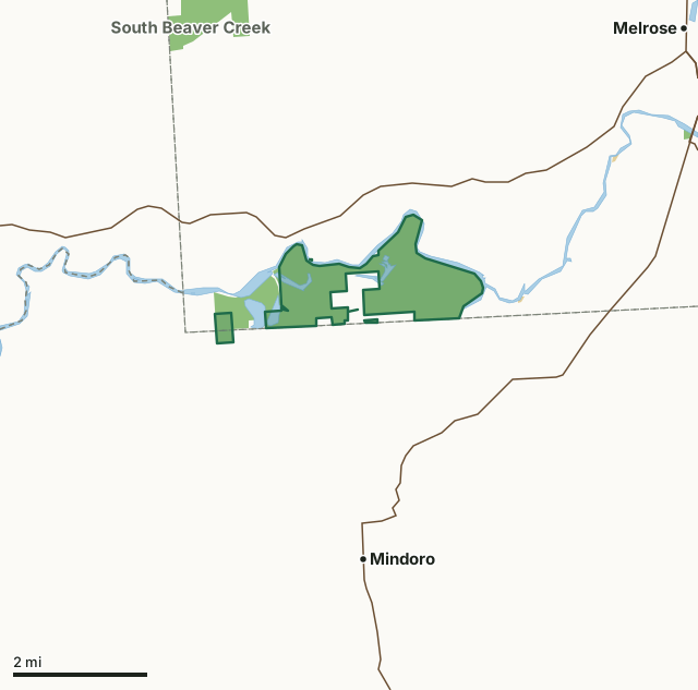
State wildlife areas, forests and other DNR landOther federal landNorth Bend Bottoms Wildlife AreaCounty lineLakeHighway
| Size | 1,686 acres in 5 pieces |
|---|---|
| Counties | Jackson County and La Crosse County |
| Deer Management Unit | DMU Jackson, La Crosse County |
| DNR lists for hunting | deer, wild turkey, ducks and geese and bear |
| Public access (DNR) | Open to Hiking, Fishing, Hunting and Trapping |
| DNR property page | North Bend Bottoms Wildlife Area |
| Nearest towns | Mindoro (4 mi), Melrose (5 mi) and Ettrick (9 mi) |
What is North Bend Bottoms Wildlife Area like?
North Bend Bottoms Wildlife Area is a 1,600-acre property located outside the town of North Bend, in southwest Jackson County. Access points can be found along Highway VV and off Lockington Road. The property consists of floodplain forest, bottomland hardwoods, marshy oxbows and some upland hardwoods and fields. The Black River borders the property on the north. This property is the jewel of the Black River, providing an outstanding habitat for wetland dependent species. The Black River provides a critical corridor for a variety of animal, bird and plant species - making any trip down the Black River a trip worth remembering.
The first parcels of land were purchased in 1962. Since then, additional acquisitions have been made by the DNR's Wildlife and Fisheries programs, with the most recent purchases occurring in 2006. Today, most management activities include the enhancement of a few sand prairies located on the east side of the property, and timber management when rotation age is reached. Most recently, a couple of parcels have been placed into state natural area designation to provide additional restoration opportunities with a focus on floodplain forest management. The North Bend Bottoms Wildlife Area offers many recreational opportunities:.
In the DNR's words, from its page for the property.
What can you hunt on North Bend Bottoms Wildlife Area?
The DNR's page for North Bend Bottoms Wildlife Area names deer, wild turkey, ducks and geese and bear. Each follows Wisconsin's statewide season and, for deer, the tags and rules of the deer management unit.
What are the rules on North Bend Bottoms Wildlife Area?
The DNR's property map lists North Bend Bottoms Wildlife Area as "Open to Hiking, Fishing, Hunting and Trapping". Hunting follows Wisconsin's statewide seasons and the rules posted on the property.
Activities the DNR lists for North Bend Bottoms Wildlife Area: Birding, Boating (launches available along Highway VV), Canoeing (launches available along Highway VV), Cross-country skiing (no designated trail), Fishing (along the Black River), Hiking (no designated trail), Hunting (noted for waterfowl, deer, turkey and bear), Kayaking (launches available along Highway VV), Trapping, Wild edibles/gathering and Wildlife viewing.
How many deer are taken around North Bend Bottoms Wildlife Area?
North Bend Bottoms Wildlife Area lies in 2 deer management units. The DNR registered 4,911 deer in DMU Jackson in 2025.
| DMU | North Bend Bottoms Wildlife Area acres in it | Deer, 2025 |
|---|---|---|
| DMU Jackson | 1,654 | 4,911 |
| La Crosse County | 32 | 4,515 |
Harvest for the whole deer management unit, not the property alone: Wisconsin DNR Deer Metrics (registered harvest by deer management unit).
How do you get to North Bend Bottoms Wildlife Area?
Nearest towns: Mindoro (4 miles), Melrose (5 miles), Ettrick (9 miles) and Holmen (9 miles). Highways within 5 miles: WI 54, WI 108 and WI 71.
What other public land is near North Bend Bottoms Wildlife Area?
DNR properties within 10 miles:
- Half Moon Lake Fishery Area: 126 acres, next to it
- South Beaver Creek Wildlife Area: 1,108 acres, 3.2 miles away
- Sand Creek Streambank Protection Area: 713 acres, 3.9 miles away
- Hardies Creek Timber Demo Forest: 56 acres, 4.8 miles away
- La Crosse Area Comprehensive Fishery Area: 2,495 acres, 6.4 miles away
Public land within 3 miles of North Bend Bottoms Wildlife Area
Counting North Bend Bottoms Wildlife Area itself, 2,008 of the 39,373 acres within 3 miles of its boundary are public land open to the public (5.1%), by USGS PAD-US 4.1 (fee land open to the public).
| Manager | Acres within 3 miles |
|---|---|
| State wildlife areas, forests and other DNR land | 1,999 |
| Other federal land | 9 |
Questions hunters ask
Where is North Bend Bottoms Wildlife Area?
In Jackson and La Crosse counties, 4 miles from Mindoro. The DNR's property page has its maps and parking.
Is North Bend Bottoms Wildlife Area open to hunting?
Yes. The DNR's property map lists it as "Open to Hiking, Fishing, Hunting and Trapping". Posted refuges or closed areas, where there are any, are marked on site.
Which deer management unit is North Bend Bottoms Wildlife Area in?
DMU Jackson (1,654 acres) and La Crosse County (32 acres).
How much public land is around North Bend Bottoms Wildlife Area?
2,008 acres within 3 miles of its boundary, North Bend Bottoms Wildlife Area included, by PAD-US 4.1. The closest other DNR property is Half Moon Lake Fishery Area (next to it).
Get a Wisconsin hunt plan when they open
Hunt plans for Wisconsin are coming. Join the list and you'll hear first. The first 50 hunters in each new state get their plan free.
Until then, the free FilledTag app for iPhone has a map that works in every state, Wisconsin included.
Where these facts come from
- Area description, species, rules and directions: DNR, North Bend Bottoms Wildlife Area; Wisconsin DNR managed lands open to hunting.
- Boundary and acres: the DNR's map layer above. Surrounding public land: USGS PAD-US 4.1 (fee land open to the public).
- Deer harvest: Wisconsin DNR Deer Metrics (registered harvest by deer management unit).
FilledTag is not part of the Wisconsin Department of Natural Resources. Check the DNR's rules and posted signs before you go.
Wisconsin hunting Jackson County La Crosse County La Crosse County