Jackson County, Wisconsin: public hunting land
Jackson County has 200,955 acres of public land open to the public, 31.4% of the county, the largest share county forest (121,396 acres), by USGS PAD-US 4.1 (fee land open to the public). The DNR's map shows 20 DNR properties here covering 78,014 acres, the largest Black River State Forest (68,618 acres in the county). The DNR's lease programs add 7 private properties open to the public, 954 acres in all. Deer here are counted by deer management unit: DMU Jackson (4,911 deer in 2025) and DMU 203 (1,167 deer in 2025).
Data updated October 2026. Land: PAD-US 4.1. DNR properties and Voluntary Public Access land: the DNR's map layers, read 2026-10. Harvest: DNR Deer Metrics.
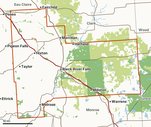
State wildlife areas, forests and other DNR landCounty forestNational wildlife refuges and waterfowl production areasOther county, city and regional landLand trusts and other open landVoluntary Public Access landJackson CountyNeighboring countiesLakeHighway
| Size | 640,226 acres (1,000 square miles) |
|---|---|
| Public land | 31.4% (200,955 acres) |
| Properties | 20 (78,014 acres) |
| Voluntary Public Access land | 7 sites, 954 acres |
| Deer management units | DMU Jackson, DMU 203 |
| Towns | Black River Falls, Merrillan, Hixton, Alma Center, Fairchild and Pigeon Falls |
How much public hunting land is in Jackson County?
200,955 of the county's 640,226 acres are public land open to the public (31.4%). 200,773 acres of that are state wildlife, state forest or federal land, where hunting is the rule rather than the exception.
| Manager | Acres | Share of Jackson County |
|---|---|---|
| County forest | 121,396 | 19% |
| State wildlife areas, forests and other DNR land | 79,088 | 12.4% |
| National wildlife refuges and waterfowl production areas | 264 | under 0.1% |
| Other county, city and regional land | 156 | under 0.1% |
| Other federal land | 25 | under 0.1% |
| State parks | 20 | under 0.1% |
| Land trusts and other open land | 6 | under 0.1% |
| All public land open to the public | 200,955 | 31.4% |
Measured by FilledTag inside the county line from USGS PAD-US 4.1 (fee land open to the public). DNR wildlife areas and state forests are open to hunting unless posted; county forests are open to hunting in most cases (check the county forest's rules); national forest land is open in season; refuges follow U.S. Fish and Wildlife Service rules; state parks allow hunting only in listed seasons and areas; national park land is closed to hunting.
The largest public areas in Jackson County by PAD-US, besides the properties: Jackson County Forest (121,280 acres) and Necedah Wildlife Management Area (1,732 acres).
Which DNR properties are in Jackson County?
20, largest first.
| Property | Acres in the county | DNR lists for hunting |
|---|---|---|
| Black River State Forest | 68,618 | |
| North Bend Bottoms Wildlife Area | 1,657 | deer, wild turkey, ducks and geese and bear |
| Meadow Valley Wildlife Area | 1,548 | deer, wild turkey, ducks and geese, ruffed grouse and small game |
| Buffalo River Fishery Area | 1,305 | deer, wild turkey, bear and small game |
| South Beaver Creek Wildlife Area | 1,108 | deer, wild turkey and pheasants |
| Halls (Stockwell) Creek Fishery Area | 858 | deer, wild turkey, bear and small game |
| Beaver Creek Rearing Station | 576 | deer, wild turkey, pheasants and small game |
| Tank Creek Fishery Area | 503 | deer, wild turkey, bear and small game |
| Jay Creek Pine Forest State Natural Area | 442 | |
| Trump Coulee Rearing Station | 425 | deer, wild turkey and small game |
| North Branch Trempealeau River Fishery Area | 328 | |
| Half Moon Lake Fishery Area | 126 | deer, wild turkey, bear and small game |
| Bauer-Brockway Barrens State Natural Area | 120 | |
| Buffalo River State Trail | 114 | |
| Smith Pond Fishery Area | 96 | deer, wild turkey, bear and small game |
| Sand Creek Streambank Protection Area | 70 | |
| Albion Rearing Station | 64 | |
| Black River Falls Service Center | 41 | |
| Roaring Creek-Black River SBE Area | 8 | |
| Trout Run-Black River SBE Area | 7 |
Where is the Voluntary Public Access land in Jackson County?
The DNR's 2026 lease map shows 7 properties in Jackson County, 954 acres of private land open to the public; 5 of them are spring-turkey-only Turkey Hunter Access land. No landowner permission is needed. DNR VPA program.
| Site | Acres | Location |
|---|---|---|
| Turkey Hunter Access property T56 | 233 | 44.3172, -91.075 |
| Turkey Hunter Access property T38 | 206 | 44.4225, -90.8274 |
| Turkey Hunter Access property T40 | 154 | 44.5568, -90.9302 |
| VPA property V267 | 140 | 44.4477, -91.0047 |
| VPA property V267 | 120 | 44.4552, -91.0255 |
| Turkey Hunter Access property T57 | 63 | 44.4672, -90.8831 |
| Turkey Hunter Access property T37 | 38 | 44.4242, -90.8348 |
Locations are the middle of each property, from the DNR's 2026 lease layer. Each property's DNR map shows its boundary and parking; THAP properties are open March 1 to May 29 for spring turkey only.
How many deer are taken in Jackson County?
Since the DNR redrew its northern and central forest units in 2025, Jackson County is split among 2 deer management units that do not follow the county line, so there is no county total. The DNR has one year of numbers for the redrawn units so far. Each figure is for the whole unit.
| DMU | Share of the county | Deer harvested in the whole DMU | Year |
|---|---|---|---|
| DMU Jackson | 51.9% | 4,911 | 2025 |
| DMU 203 | 48.1% | 1,167 | 2025 |
Harvest: Wisconsin DNR Deer Metrics (registered harvest by deer management unit). Share of the county measured by FilledTag from the DNR's deer management units and the Census county line.
How do you get around Jackson County?
Highways: I-94 (about 82 miles in the county), WI 54 (about 55 miles in the county), US 12 (about 34 miles in the county), WI 95 (about 28 miles in the county) and WI 27 (about 27 miles in the county). Towns: Black River Falls, Merrillan, Hixton, Alma Center, Melrose, Taylor, Hatfield and Millston.
Questions hunters ask
How much public hunting land is in Jackson County, Wisconsin?
200,955 acres, 31.4% of the county, are public land open to the public by PAD-US 4.1; the largest share is county forest (121,396 acres).
What is the largest DNR property in Jackson County?
Black River State Forest, with 68,618 acres inside the county.
Which deer management units cover Jackson County?
DMU Jackson (51.9%) and DMU 203 (48.1%).
Does Jackson County have VPA land?
Yes. 7 properties, 954 acres, on the DNR's 2026 lease map.
Get a Wisconsin hunt plan when they open
Hunt plans for Wisconsin are coming. Join the list and you'll hear first. The first 50 hunters in each new state get their plan free.
Until then, the free FilledTag app for iPhone has a map that works in every state, Wisconsin included.
Where these numbers come from
- Public land: USGS PAD-US 4.1 (fee land open to the public). DNR properties: Wisconsin DNR managed lands open to hunting. Voluntary Public Access land: Wisconsin DNR Voluntary Public Access and Turkey Hunting Program lands.
- Deer harvest: Wisconsin DNR Deer Metrics (registered harvest by deer management unit).
- County line: U.S. Census Bureau 2024 cartographic county boundaries. Highways and towns: U.S. Census Bureau TIGER/Line 2024 primary and secondary roads.
FilledTag is not part of the Wisconsin Department of Natural Resources. Numbers are copied from the DNR and the federal sources above, or measured from their maps.
Wisconsin hunting Wood County Clark County Juneau County Monroe County Eau Claire County Voluntary Public Access land