Meadow Valley Wildlife Area: hunting and access
Meadow Valley Wildlife Area is 58,144 acres of land managed by the Wisconsin DNR in Juneau, Monroe, Wood and Jackson counties, 2 miles from Babcock. The DNR's page for it names deer, wild turkey, ducks and geese, ruffed grouse and small game among the game here. Hunters registered 657 deer in DMU 206 in 2025.
Data updated October 2026. Area facts: the DNR's DNR property data, read 2026-10. Harvest: DNR Deer Metrics.
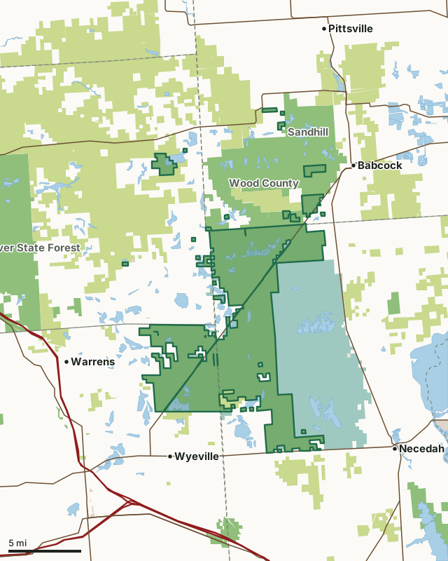
State wildlife areas, forests and other DNR landCounty forestNational wildlife refuges and waterfowl production areasOther federal landOther county, city and regional landLand trusts and other open landMeadow Valley Wildlife AreaCounty lineLakeHighway
| Size | 58,144 acres in 27 pieces |
|---|---|
| Counties | Juneau County, Monroe County, Wood County and Jackson County |
| Deer Management Unit | DMU 206, DMU 205, DMU 204, DMU 203 |
| DNR lists for hunting | deer, wild turkey, ducks and geese, ruffed grouse and small game |
| Public access (DNR) | Open to Hiking, Fishing, Hunting and Trapping |
| DNR property page | Meadow Valley Wildlife Area |
| Nearest towns | Babcock (2 mi), Wyeville (3 mi) and Necedah (5 mi) |
What is Meadow Valley Wildlife Area like?
Meadow Valley Wildlife Area encompasses approximately 56,000 acres and is located in between Babcock and Necedah, about two hours north of Madison. It is 25 miles southwest of Wisconsin Rapids and 20 miles north of Mauston. Access can also be found 1 mile west of Babcock on Highway X. Most of the land that makes up Meadow Valley Wildlife Area is federally owned land that is managed by the Department under a Cooperative Agreement with the US Fish and Wildlife Service. DNR staff manage the Sandhill Wildlife Area, Wood County Wildlife Area and the Meadow Valley Wildlife Area collectively. Together, these three Wildlife Areas are referred to as the Sandhill-Meadow Valley Work Unit. They make up the largest block of state-managed wildlife lands in Wisconsin. Nearly 150 square miles of public lands lie within the work unit.
Meadow Valley Wildlife Area provides a unique experience as it offers an exceptional variety of hunting and recreational opportunities. The diverse habitat management practices implemented on the property provide ample opportunities for hunting deer, wild turkey, ruffed grouse, small game, waterfowl, and trapping furbearers. In addition to hunting opportunities, the size and diversity of the property provide opportunities for hiking, berry picking and observing wildlife in a truly natural setting. The 1,175-acre wildlife refuge on Meadow Valley Flowage provides an excellent opportunity to observe migrating waterfowl in spring and fall. The wildlife area lies within the bed of old Glacial Lake Wisconsin. The topography is flat with a mixture of large marshes and low sandy ridges. Most of the sand was deposited by wind after the glacial waters receded.
In the DNR's words, from its page for the property.
What can you hunt on Meadow Valley Wildlife Area?
The DNR's page for Meadow Valley Wildlife Area names deer, wild turkey, ducks and geese, ruffed grouse and small game. Each follows Wisconsin's statewide season and, for deer, the tags and rules of the deer management unit.
What are the rules on Meadow Valley Wildlife Area?
The DNR's property map lists Meadow Valley Wildlife Area as "Open to Hiking, Fishing, Hunting and Trapping". Hunting follows Wisconsin's statewide seasons and the rules posted on the property.
Activities the DNR lists for Meadow Valley Wildlife Area: Birding, Boating (non-motorized), Camping (see below for details), Canoeing, Cross-country skiing (no designated trail), Fishing, Hiking (no designated trail), Hunting (noted for waterfowl and turkey), Snowmobiling (restricted to marked trails), Trapping, Wild edibles/gathering and Wildlife viewing.
How many deer are taken around Meadow Valley Wildlife Area?
Meadow Valley Wildlife Area lies in 4 deer management units. The DNR registered 657 deer in DMU 206 in 2025.
| DMU | Meadow Valley Wildlife Area acres in it | Deer, 2025 |
|---|---|---|
| DMU 206 | 38,732 | 657 |
| DMU 205 | 15,565 | 448 |
| DMU 204 | 2,319 | 598 |
| DMU 203 | 1,526 | 1,167 |
Harvest for the whole deer management unit, not the property alone: Wisconsin DNR Deer Metrics (registered harvest by deer management unit).
How do you get to Meadow Valley Wildlife Area?
Nearest towns: Babcock (2 miles), Wyeville (3 miles), Necedah (5 miles) and Warrens (5 miles). Highways within 5 miles: WI 173, WI 80, WI 54 and WI 21.
What other public land is near Meadow Valley Wildlife Area?
DNR properties within 10 miles:
- Sandhill Wildlife Area: 9,653 acres, next to it
- Wood County Wildlife Area: 19,261 acres, next to it
- Jay Creek Pine Forest State Natural Area: 442 acres, 3.6 miles away
- Mill Creek Fishery Area: 109 acres, 4.8 miles away
- Mill Bluff State Park: 1,616 acres, 5 miles away
- Black River State Forest: 68,941 acres, 5.1 miles away
Public land within 3 miles of Meadow Valley Wildlife Area
Counting Meadow Valley Wildlife Area itself, 157,293 of the 282,005 acres within 3 miles of its boundary are public land open to the public (55.8%), by USGS PAD-US 4.1 (fee land open to the public).
| Manager | Acres within 3 miles |
|---|---|
| State wildlife areas, forests and other DNR land | 85,269 |
| County forest | 39,338 |
| National wildlife refuges and waterfowl production areas | 32,638 |
| Other county, city and regional land | 48 |
Questions hunters ask
Where is Meadow Valley Wildlife Area?
In Juneau, Monroe, Wood and Jackson counties, 2 miles from Babcock. The DNR's property page has its maps and parking.
Is Meadow Valley Wildlife Area open to hunting?
Yes. The DNR's property map lists it as "Open to Hiking, Fishing, Hunting and Trapping". Posted refuges or closed areas, where there are any, are marked on site.
Which deer management unit is Meadow Valley Wildlife Area in?
DMU 206 (38,732 acres), DMU 205 (15,565 acres), DMU 204 (2,319 acres) and DMU 203 (1,526 acres).
How much public land is around Meadow Valley Wildlife Area?
157,293 acres within 3 miles of its boundary, Meadow Valley Wildlife Area included, by PAD-US 4.1. The closest other DNR property is Sandhill Wildlife Area (next to it).
Get a Wisconsin hunt plan when they open
Hunt plans for Wisconsin are coming. Join the list and you'll hear first. The first 50 hunters in each new state get their plan free.
Until then, the free FilledTag app for iPhone has a map that works in every state, Wisconsin included.
Where these facts come from
- Area description, species, rules and directions: DNR, Meadow Valley Wildlife Area; Wisconsin DNR managed lands open to hunting.
- Boundary and acres: the DNR's map layer above. Surrounding public land: USGS PAD-US 4.1 (fee land open to the public).
- Deer harvest: Wisconsin DNR Deer Metrics (registered harvest by deer management unit).
FilledTag is not part of the Wisconsin Department of Natural Resources. Check the DNR's rules and posted signs before you go.
Wisconsin hunting Juneau County Monroe County Wood County Jackson County