Sandhill Wildlife Area: hunting and access
Sandhill Wildlife Area is 9,653 acres of land managed by the Wisconsin DNR in Wood County, next to Babcock. Hunters registered 598 deer in DMU 204 in 2025.
Data updated October 2026. Area facts: the DNR's DNR property data, read 2026-10. Harvest: DNR Deer Metrics.
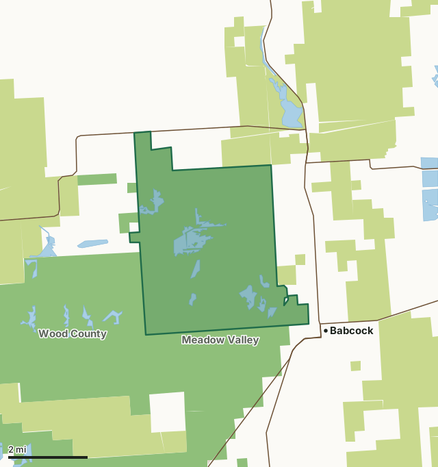
State wildlife areas, forests and other DNR landCounty forestNational wildlife refuges and waterfowl production areasOther county, city and regional landSandhill Wildlife AreaCounty lineLakeHighway
| Size | 9,653 acres |
|---|---|
| County | Wood County |
| Deer Management Unit | DMU 204 |
| Public access (DNR) | Open to Hiking, Fishing, Hunting and Trapping |
| DNR property page | Sandhill Wildlife Area |
| Nearest towns | Babcock (next to it), Pittsville (5 mi) and Ceex Haci (8 mi) |
What is Sandhill Wildlife Area like?
Sandhill Wildlife Area spans an impressive 9,150 acres in the ancient Glacial Lake Wisconsin bed. Its name derives from a series of gently rolling sandy ridges crisscrossing the property. Managed by a team of Wisconsin Department of Natural Resources (DNR) employees, this property boasts a unique 9-foot deer-proof fence, which creates an ideal environment for wildlife research. Special permits and restrictions are in place within the fenced area of the property; however, visitors are welcome to enter through the designated entrance gates to explore and recreate. DNR staff collectively manage the Sandhill Wildlife Area, Wood County Wildlife Area, and the Meadow Valley Wildlife Area. Together, these three wildlife areas are called the Sandhill-Meadow Valley Work Unit. They make up the largest block of state-managed wildlife lands in Wisconsin.
When exploring the Sandhill Wildlife Area, visitors are captivated by its diverse inhabitants and scenic landscapes. From a small herd of American bison to white-tailed deer, and from the majestic bald eagles to thousands of sandhill cranes flying in to roost during fall, the property offers a haven for various wildlife species. The low, sandy uplands feature oak, aspen and jack pine forests, creating a picturesque setting for wildlife viewing, birdwatching, hiking, hunting (by permit) and much more. A 14-mile Trumpeter Trail auto tour highlights Sandhill Wildlife Area. This one-way auto tour, typically open from spring to fall, meanders through Sandhill's unique landscape. Vehicles, bicycles and hikers are welcome on the trail. All property users must register at the kiosk and adhere to trail hours. Sandhill Wildlife Area is located in southwestern Wood County.
In the DNR's words, from its page for the property.
What are the rules on Sandhill Wildlife Area?
The DNR's property map lists Sandhill Wildlife Area as "Open to Hiking, Fishing, Hunting and Trapping". Hunting follows Wisconsin's statewide seasons and the rules posted on the property.
Activities the DNR lists for Sandhill Wildlife Area: The Bison Byway is a spur of the Trumpeter Trail that allows visitors to see more of the bison enclosure.
How many deer are taken around Sandhill Wildlife Area?
Sandhill Wildlife Area lies in DMU 204. The DNR registered 598 deer in DMU 204 in 2025.
| DMU | Sandhill Wildlife Area acres in it | Deer, 2025 |
|---|---|---|
| DMU 204 | 9,653 | 598 |
Harvest for the whole deer management unit, not the property alone: Wisconsin DNR Deer Metrics (registered harvest by deer management unit).
How do you get to Sandhill Wildlife Area?
Nearest towns: Babcock (next to it), Pittsville (5 miles), Ceex Haci (8 miles) and Nekoosa (10 miles). Highways within 5 miles: WI 54, WI 80 and WI 173.
What other public land is near Sandhill Wildlife Area?
DNR properties within 10 miles:
- Meadow Valley Wildlife Area: 58,144 acres, next to it
- Wood County Wildlife Area: 19,261 acres, next to it
- Cranberry Creek Mound Group SNA: 676 acres, 9.4 miles away
Public land within 3 miles of Sandhill Wildlife Area
Counting Sandhill Wildlife Area itself, 35,991 of the 61,252 acres within 3 miles of its boundary are public land open to the public (58.8%), by USGS PAD-US 4.1 (fee land open to the public).
| Manager | Acres within 3 miles |
|---|---|
| State wildlife areas, forests and other DNR land | 21,564 |
| County forest | 14,420 |
| National wildlife refuges and waterfowl production areas | 4 |
| Other county, city and regional land | 3 |
Questions hunters ask
Where is Sandhill Wildlife Area?
In Wood County, next to Babcock. The DNR's property page has its maps and parking.
Is Sandhill Wildlife Area open to hunting?
Yes. The DNR's property map lists it as "Open to Hiking, Fishing, Hunting and Trapping". Posted refuges or closed areas, where there are any, are marked on site.
Which deer management unit is Sandhill Wildlife Area in?
DMU 204.
How much public land is around Sandhill Wildlife Area?
35,991 acres within 3 miles of its boundary, Sandhill Wildlife Area included, by PAD-US 4.1. The closest other DNR property is Meadow Valley Wildlife Area (next to it).
Get a Wisconsin hunt plan when they open
Hunt plans for Wisconsin are coming. Join the list and you'll hear first. The first 50 hunters in each new state get their plan free.
Until then, the free FilledTag app for iPhone has a map that works in every state, Wisconsin included.
Where these facts come from
- Area description, species, rules and directions: DNR, Sandhill Wildlife Area; Wisconsin DNR managed lands open to hunting.
- Boundary and acres: the DNR's map layer above. Surrounding public land: USGS PAD-US 4.1 (fee land open to the public).
- Deer harvest: Wisconsin DNR Deer Metrics (registered harvest by deer management unit).
FilledTag is not part of the Wisconsin Department of Natural Resources. Check the DNR's rules and posted signs before you go.