Cranberry Creek Mound Group SNA: hunting and access
Cranberry Creek Mound Group SNA is 676 acres of land managed by the Wisconsin DNR in Juneau County, 9 miles from Ceex Haci. Hunters registered 657 deer in DMU 206 in 2025.
Data updated October 2026. Area facts: the DNR's DNR property data, read 2026-10. Harvest: DNR Deer Metrics.
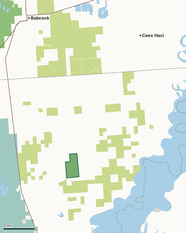
State wildlife areas, forests and other DNR landCounty forestNational wildlife refuges and waterfowl production areasOther county, city and regional landLand trusts and other open landCranberry Creek Mound Group SNACounty lineLakeHighway
| Size | 676 acres |
|---|---|
| County | Juneau County |
| Deer Management Unit | DMU 206 |
| Public access (DNR) | Open to Hiking, Fishing, Hunting and Trapping |
| DNR property page | Cranberry Creek Mound Group |
| Nearest towns | Ceex Haci (9 mi), Babcock (9 mi) and Necedah (9 mi) |
What is Cranberry Creek Mound Group SNA like?
Cranberry Creek Mound Group preserves one of the most significant archeological sites in Wisconsin and one of the largest and best-preserved mound complexes in the Upper Midwest. The site contains excellent examples of conical, linear, oval, and effigy mounds built by Native Americans of the Woodland period (ca. 100-800 A.D.). Although the northern cluster has been altered somewhat by plowing, the southern cluster is unaltered. Among the mounds featured are bear/panther mounds and a 50-foot-long bird effigy mound with a wingspan of 125 feet. Although the mounds are featured, the site also contains a diversity of natural communities. Along the ditched channel of Cranberry Creek, large river birch and silver and red maples dominate the floodplain forest. Also present is an old-growth northern dry forest with large jack pine and an open pine-oak forest.
Juneau County. T20N-R4E, Sections 30, 31. 675 acres. From the intersection of State Highway 21 and County Highway G east of Necedah, go north on G about 9.8 miles to its junction with County Highway F and 7th Street. Park at the southwest corner of the intersection and walk west along 7th Street into the site. The best mounds are located east of Cranberry Creek, north of the drainage ditch and south of 7th Street. Access also from 8th Street, one mile to the south.
In the DNR's words, from its page for the property.
What are the rules on Cranberry Creek Mound Group SNA?
The DNR's property map lists Cranberry Creek Mound Group SNA as "Open to Hiking, Fishing, Hunting and Trapping". Hunting follows Wisconsin's statewide seasons and the rules posted on the property.
How many deer are taken around Cranberry Creek Mound Group SNA?
Cranberry Creek Mound Group SNA lies in DMU 206. The DNR registered 657 deer in DMU 206 in 2025.
| DMU | Cranberry Creek Mound Group SNA acres in it | Deer, 2025 |
|---|---|---|
| DMU 206 | 676 | 657 |
Harvest for the whole deer management unit, not the property alone: Wisconsin DNR Deer Metrics (registered harvest by deer management unit).
How do you get to Cranberry Creek Mound Group SNA?
Nearest towns: Ceex Haci (9 miles), Babcock (9 miles), Necedah (9 miles) and Lake Arrowhead (11 miles). Highways within 5 miles: WI 80.
What other public land is near Cranberry Creek Mound Group SNA?
DNR properties within 10 miles:
- Meadow Valley Wildlife Area: 58,144 acres, 5.2 miles away
- Central Sands Pines Forest Legacy Easement: 9,122 acres, 7.4 miles away
- Wood County Wildlife Area: 19,261 acres, 7.6 miles away
- Sandhill Wildlife Area: 9,653 acres, 9.4 miles away
Public land within 3 miles of Cranberry Creek Mound Group SNA
Counting Cranberry Creek Mound Group SNA itself, 7,146 of the 27,217 acres within 3 miles of its boundary are public land open to the public (26.3%), by USGS PAD-US 4.1 (fee land open to the public).
| Manager | Acres within 3 miles |
|---|---|
| County forest | 6,469 |
| State wildlife areas, forests and other DNR land | 676 |
| National wildlife refuges and waterfowl production areas | 1 |
Questions hunters ask
Where is Cranberry Creek Mound Group SNA?
In Juneau County, 9 miles from Ceex Haci. The DNR's property page has its maps and parking.
Is Cranberry Creek Mound Group SNA open to hunting?
Yes. The DNR's property map lists it as "Open to Hiking, Fishing, Hunting and Trapping". Posted refuges or closed areas, where there are any, are marked on site.
Which deer management unit is Cranberry Creek Mound Group SNA in?
DMU 206.
How much public land is around Cranberry Creek Mound Group SNA?
7,146 acres within 3 miles of its boundary, Cranberry Creek Mound Group SNA included, by PAD-US 4.1. The closest other DNR property is Meadow Valley Wildlife Area (5.2 miles).
Get a Wisconsin hunt plan when they open
Hunt plans for Wisconsin are coming. Join the list and you'll hear first. The first 50 hunters in each new state get their plan free.
Until then, the free FilledTag app for iPhone has a map that works in every state, Wisconsin included.
Where these facts come from
- Area description, species, rules and directions: DNR, Cranberry Creek Mound Group SNA; Wisconsin DNR managed lands open to hunting.
- Boundary and acres: the DNR's map layer above. Surrounding public land: USGS PAD-US 4.1 (fee land open to the public).
- Deer harvest: Wisconsin DNR Deer Metrics (registered harvest by deer management unit).
FilledTag is not part of the Wisconsin Department of Natural Resources. Check the DNR's rules and posted signs before you go.