Wood County Wildlife Area: hunting and access
Wood County Wildlife Area is 19,261 acres of land managed by the Wisconsin DNR in Wood and Jackson counties, next to Babcock. The DNR's page for it names deer, ducks and geese, ruffed grouse, woodcock and rabbits and squirrels among the game here. Hunters registered 598 deer in DMU 204 in 2025.
Data updated October 2026. Area facts: the DNR's DNR property data, read 2026-10. Harvest: DNR Deer Metrics.
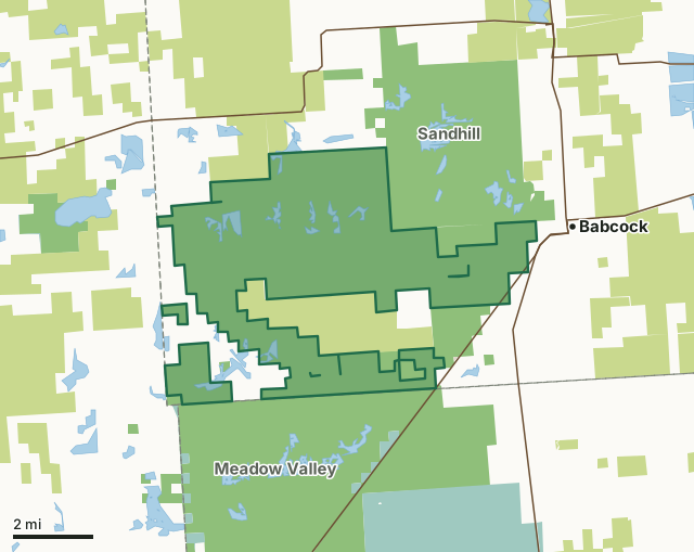
State wildlife areas, forests and other DNR landCounty forestNational wildlife refuges and waterfowl production areasOther county, city and regional landWood County Wildlife AreaCounty lineLakeHighway
| Size | 19,261 acres in 3 pieces |
|---|---|
| Counties | Wood County and Jackson County |
| Deer Management Unit | DMU 204, DMU 206 |
| DNR lists for hunting | deer, ducks and geese, ruffed grouse, woodcock and rabbits and squirrels |
| Public access (DNR) | Open to Hiking, Fishing, Hunting and Trapping |
| DNR property page | Wood County Wildlife Area |
| Nearest towns | Babcock (next to it), Pittsville (8 mi) and Ceex Haci (8 mi) |
What is Wood County Wildlife Area like?
Wood County Wildlife Area is a 21,000-acre property in southwestern Wood County, approximately 20 miles north of Necedah, 25 miles south of Marshfield and 18 miles west of Wisconsin Rapids. Wood County Wildlife Area lies within the bed of historic Glacial Lake Wisconsin, an area characterized by large expanses of wetlands interspersed with forested uplands and islands. The area lies between the Meadow Valley Wildlife Area on the south and the Sandhill Wildlife Area on the north. Collectively, these three areas are referred to as the Sandhill-Meadow Valley Work Unit, the largest block of state-managed wildlife lands in Wisconsin. Nearly 150 square miles of public lands lie within the work unit. The primary recreational uses for Wood County Wildlife area are hunting, trapping, and wildlife observation.
Wood County Wildlife Area lies within the bed of historic Glacial Lake Wisconsin, an area characterized by large expanses of wetlands interspersed with forested uplands and islands. The original vegetation consisted primarily of sedge, grasses, tamarack and black spruce in the wetlands and white and red pine forests mixed with oak on the uplands. During the 1800s, the land was logged and burned to create openings. Pioneer farmers followed, but their activities were limited by naturally high water tables, short growing seasons and poor soils. During the land boom of the early 1900s, widespread efforts were made to drain the area. The first drainage ditch in the area was constructed in 1902. In all, about 60 miles of ditches were constructed in the Town of Remington. Ditching was somewhat successful in improving drainage, but the attempt to develop an agricultural economy failed.
In the DNR's words, from its page for the property.
What can you hunt on Wood County Wildlife Area?
The DNR's page for Wood County Wildlife Area names deer, ducks and geese, ruffed grouse, woodcock and rabbits and squirrels. Each follows Wisconsin's statewide season and, for deer, the tags and rules of the deer management unit.
What are the rules on Wood County Wildlife Area?
The DNR's property map lists Wood County Wildlife Area as "Open to Hiking, Fishing, Hunting and Trapping". Hunting follows Wisconsin's statewide seasons and the rules posted on the property.
Activities the DNR lists for Wood County Wildlife Area: Birding.
How many deer are taken around Wood County Wildlife Area?
Wood County Wildlife Area lies in 2 deer management units. The DNR registered 598 deer in DMU 204 in 2025.
| DMU | Wood County Wildlife Area acres in it | Deer, 2025 |
|---|---|---|
| DMU 204 | 19,259 | 598 |
| DMU 206 | 1 | 657 |
Harvest for the whole deer management unit, not the property alone: Wisconsin DNR Deer Metrics (registered harvest by deer management unit).
How do you get to Wood County Wildlife Area?
Nearest towns: Babcock (next to it), Pittsville (8 miles), Ceex Haci (8 miles) and Nekoosa (11 miles). Highways within 5 miles: WI 54, WI 173 and WI 80.
What other public land is near Wood County Wildlife Area?
DNR properties within 10 miles:
- Sandhill Wildlife Area: 9,653 acres, next to it
- Meadow Valley Wildlife Area: 58,144 acres, next to it
- Cranberry Creek Mound Group SNA: 676 acres, 7.6 miles away
- Jay Creek Pine Forest State Natural Area: 442 acres, 9.8 miles away
Public land within 3 miles of Wood County Wildlife Area
Counting Wood County Wildlife Area itself, 61,865 of the 98,924 acres within 3 miles of its boundary are public land open to the public (62.5%), by USGS PAD-US 4.1 (fee land open to the public).
| Manager | Acres within 3 miles |
|---|---|
| State wildlife areas, forests and other DNR land | 45,136 |
| County forest | 15,371 |
| National wildlife refuges and waterfowl production areas | 1,350 |
| Other county, city and regional land | 8 |
Questions hunters ask
Where is Wood County Wildlife Area?
In Wood and Jackson counties, next to Babcock. The DNR's property page has its maps and parking.
Is Wood County Wildlife Area open to hunting?
Yes. The DNR's property map lists it as "Open to Hiking, Fishing, Hunting and Trapping". Posted refuges or closed areas, where there are any, are marked on site.
Which deer management unit is Wood County Wildlife Area in?
DMU 204 (19,259 acres) and DMU 206 (1 acres).
How much public land is around Wood County Wildlife Area?
61,865 acres within 3 miles of its boundary, Wood County Wildlife Area included, by PAD-US 4.1. The closest other DNR property is Sandhill Wildlife Area (next to it).
Get a Wisconsin hunt plan when they open
Hunt plans for Wisconsin are coming. Join the list and you'll hear first. The first 50 hunters in each new state get their plan free.
Until then, the free FilledTag app for iPhone has a map that works in every state, Wisconsin included.
Where these facts come from
- Area description, species, rules and directions: DNR, Wood County Wildlife Area; Wisconsin DNR managed lands open to hunting.
- Boundary and acres: the DNR's map layer above. Surrounding public land: USGS PAD-US 4.1 (fee land open to the public).
- Deer harvest: Wisconsin DNR Deer Metrics (registered harvest by deer management unit).
FilledTag is not part of the Wisconsin Department of Natural Resources. Check the DNR's rules and posted signs before you go.