Observatory Hill State Natural Area: hunting and access
Observatory Hill State Natural Area is 178 acres of land managed by the Wisconsin DNR in Marquette County, 6 miles from Montello. Hunters registered 7,790 deer in Marquette County in 2025.
Data updated October 2026. Area facts: the DNR's DNR property data, read 2026-10. Harvest: DNR Deer Metrics.
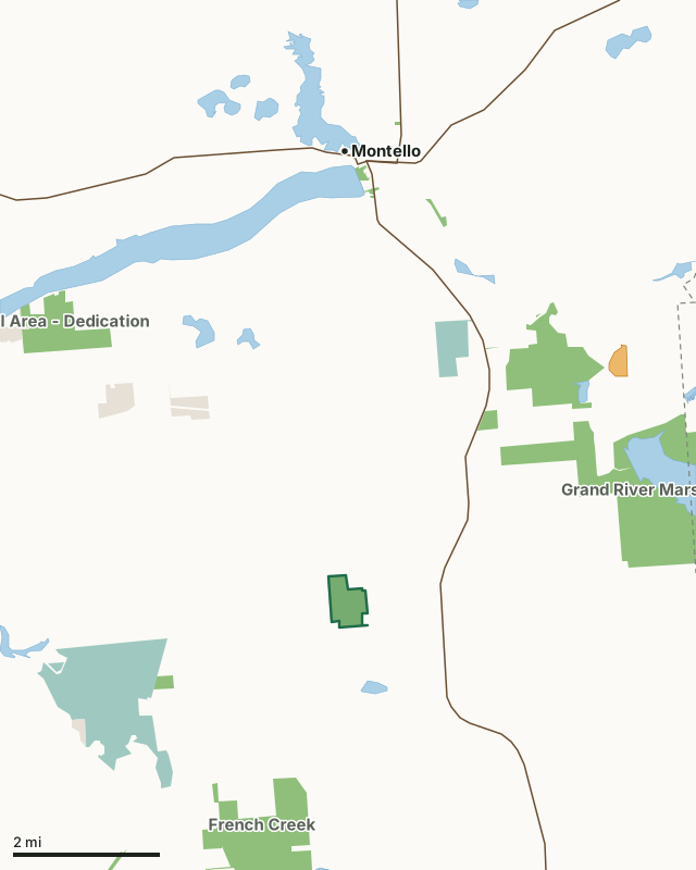
State wildlife areas, forests and other DNR landNational wildlife refuges and waterfowl production areasLand trusts and other open landVoluntary Public Access landObservatory Hill State Natural AreaCounty lineLakeHighway
| Size | 178 acres |
|---|---|
| County | Marquette County |
| Deer Management Unit | Marquette County |
| Public access (DNR) | Open to Hiking, Fishing, Hunting and Trapping |
| DNR property page | Observatory Hill |
| Nearest towns | Montello (6 mi), Endeavor (6 mi) and Packwaukee (7 mi) |
What is Observatory Hill State Natural Area like?
Rising 300 feet above the surrounding landscape is Observatory Hill, an isolated outcropping of porphyritic rhyolite and one of the highest points in the county. The fine-grained rhyolite, an igneous rock embedded with feldspar crystals, is highly resistant to erosion and has been dated to 1.76 billion years ago. On the exposed rocks at the summit are polished rock surfaces with grooves, striations, and chatter marks created by the passage of the glacial Cary ice sheet 12,000 years ago. Near the top of the hill, bedrock is exposed or close to the surface creating acidic conditions where a specialized glade community has developed. Red cedar dominates the glade and the thin soils support a sparse ground cover of mosses, ferns, and lichens.
Entrance fees : Except for Parfrey's Glen, Pewits Nest, Gibraltar Rock, the Dells of the Wisconsin River, SNAs within State Parks and some within State Forests, all other DNR-owned SNAs do not have any admission fees. Admin. Code NR 45. Marquette County. T14N-R10E, Section 8. 208 acres. From the intersection of Highways 22 and F on the south side of Montello, go south on F for 4.8 miles, then east on 14th Road for 0.5 miles, then south on 13th Road for 1.4 miles, then east on Gillette Avenue for 0.6 miles to a parking area north of the road. A footpath to the summit begins at the northwest corner of the old field. Observatory Hill is owned by the Wisconsin DNR and private individuals.
In the DNR's words, from its page for the property.
What are the rules on Observatory Hill State Natural Area?
The DNR's property map lists Observatory Hill State Natural Area as "Open to Hiking, Fishing, Hunting and Trapping". Hunting follows Wisconsin's statewide seasons and the rules posted on the property.
How many deer are taken around Observatory Hill State Natural Area?
Observatory Hill State Natural Area lies in Marquette County. The DNR registered 7,790 deer in Marquette County in 2025, against 7,744 in 2024.
| DMU | Observatory Hill State Natural Area acres in it | Deer, 2025 | Deer, 2024 | Deer, 2023 |
|---|---|---|---|---|
| Marquette County | 178 | 7,790 | 7,744 | 6,550 |
Harvest for the whole deer management unit, not the property alone: Wisconsin DNR Deer Metrics (registered harvest by deer management unit).
How do you get to Observatory Hill State Natural Area?
Nearest towns: Montello (6 miles), Endeavor (6 miles), Packwaukee (7 miles) and Dalton (7 miles). Highways within 5 miles: WI 22.
What other public land is near Observatory Hill State Natural Area?
DNR properties within 10 miles:
- French Creek Wildlife Area: 3,764 acres, 2.1 miles away
- Grand River Marsh Wildlife Area: 7,648 acres, 2.5 miles away
- Upper Fox River Public Access: 401 acres, 3.6 miles away
- Andrew Krakow Public Access And Fishery Area: 23 acres, 5.2 miles away
Public land within 3 miles of Observatory Hill State Natural Area
Counting Observatory Hill State Natural Area itself, 1,091 of the 22,483 acres within 3 miles of its boundary are public land open to the public (4.9%), by USGS PAD-US 4.1 (fee land open to the public).
| Manager | Acres within 3 miles |
|---|---|
| State wildlife areas, forests and other DNR land | 673 |
| National wildlife refuges and waterfowl production areas | 373 |
| Land trusts and other open land | 44 |
| Other county, city and regional land | 1 |
Questions hunters ask
Where is Observatory Hill State Natural Area?
In Marquette County, 6 miles from Montello. The DNR's property page has its maps and parking.
Is Observatory Hill State Natural Area open to hunting?
Yes. The DNR's property map lists it as "Open to Hiking, Fishing, Hunting and Trapping". Posted refuges or closed areas, where there are any, are marked on site.
Which deer management unit is Observatory Hill State Natural Area in?
Marquette County.
How much public land is around Observatory Hill State Natural Area?
1,091 acres within 3 miles of its boundary, Observatory Hill State Natural Area included, by PAD-US 4.1. The closest other DNR property is French Creek Wildlife Area (2.1 miles).
Get a Wisconsin hunt plan when they open
Hunt plans for Wisconsin are coming. Join the list and you'll hear first. The first 50 hunters in each new state get their plan free.
Until then, the free FilledTag app for iPhone has a map that works in every state, Wisconsin included.
Where these facts come from
- Area description, species, rules and directions: DNR, Observatory Hill State Natural Area; Wisconsin DNR managed lands open to hunting.
- Boundary and acres: the DNR's map layer above. Surrounding public land: USGS PAD-US 4.1 (fee land open to the public).
- Deer harvest: Wisconsin DNR Deer Metrics (registered harvest by deer management unit).
FilledTag is not part of the Wisconsin Department of Natural Resources. Check the DNR's rules and posted signs before you go.