Parfreys Glen State Natural Area: hunting and access
Parfreys Glen State Natural Area is 510 acres of land managed by the Wisconsin DNR in Sauk County, 2 miles from Merrimac. Hunters registered 6,025 deer in Sauk County in 2025.
Data updated October 2026. Area facts: the DNR's DNR property data, read 2026-10. Harvest: DNR Deer Metrics.
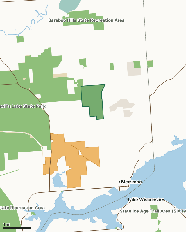
State wildlife areas, forests and other DNR landNational wildlife refuges and waterfowl production areasState parksLand trusts and other open landVoluntary Public Access landParfreys Glen State Natural AreaCounty lineLakeHighway
| Size | 510 acres |
|---|---|
| County | Sauk County |
| Deer Management Unit | Sauk County |
| Public access (DNR) | Open to Hiking, Fishing, Hunting and Trapping |
| DNR property page | Parfrey's Glen |
| Nearest towns | Merrimac (2 mi), Lake Wisconsin (4 mi) and Baraboo (5 mi) |
What is Parfreys Glen State Natural Area like?
Parfrey's Glen, Wisconsin's first State Natural Area, is a spectacular gorge deeply incised into the sandstone conglomerate of the south flank of the Baraboo Hills. The walls of the glen - a Scottish word for a narrow, rocky ravine - are sandstone with embedded, rounded quartzite pebbles, cobbles and boulders. The Baraboo Range is described by geologists as exhumed monadnocks composed largely of massive, pink, maroon or purple Precambrian Baraboo quartzite. Sedimentary rocks of Cambrian and Ordovician ages overlay the basement rock that contain spectacular basal conglomerates in many places. The exposed Cambrian layers provide excellent opportunities for geological interpretation and represent depositions of a Cambrian sea at a point estimated to be a mile from shore. The moss-covered walls are moist from seepage, cool and shaded.
Within Devil's Lake State Park, Sauk County. T11N-R7E, Sections 14, 15, 22, 23. 508 acres. From the intersection of Highways 78 and 113 in Merrimac, go west on Hwy 113 for 0.1 miles, then north on Baraboo Street (Bluff Road) for 2.5 miles to County Highway DL, then west 0.3 miles to a parking area on the north side of the highway. A trail leads north into the natural area. A short segment at the beginning of the trail is wheelchair accessible. Note : Catastrophic floods destroyed the boardwalk and bridges that once provided access to the scenic cliffs and waterfall in the heart of the glen. They were not replaced. Hikers must now walk along the rocky creek bed and ford the shallow stream in one place to see these features. Visitors may not venture past the waterfall. The round-trip hike into the glen is 1.6 miles.
In the DNR's words, from its page for the property.
What are the rules on Parfreys Glen State Natural Area?
The DNR's property map lists Parfreys Glen State Natural Area as "Open to Hiking, Fishing, Hunting and Trapping". Hunting follows Wisconsin's statewide seasons and the rules posted on the property.
How many deer are taken around Parfreys Glen State Natural Area?
Parfreys Glen State Natural Area lies in Sauk County. The DNR registered 6,025 deer in Sauk County in 2025, against 5,739 in 2024.
| DMU | Parfreys Glen State Natural Area acres in it | Deer, 2025 | Deer, 2024 | Deer, 2023 |
|---|---|---|---|---|
| Sauk County | 510 | 6,025 | 5,739 | 6,262 |
Harvest for the whole deer management unit, not the property alone: Wisconsin DNR Deer Metrics (registered harvest by deer management unit).
How do you get to Parfreys Glen State Natural Area?
Nearest towns: Merrimac (2 miles), Lake Wisconsin (4 miles), Baraboo (5 miles) and West Baraboo (7 miles). Highways within 5 miles: WI 113, WI 78, WI 33, WI 188 and WI 123. 1 VPA property within 3 miles.
What other public land is near Parfreys Glen State Natural Area?
DNR properties within 10 miles:
- Baraboo Hills State Recreation Area: 1,143 acres, next to it
- Devil's Lake State Park: 9,796 acres, next to it
- State Ice Age Trail Area (SIATA): 4,676 acres, 0.5 miles away
- Lower Wisconsin State Riverway: 47,767 acres, 2.9 miles away
- Great Sauk State Trail: 106 acres, 3.2 miles away
Public land within 3 miles of Parfreys Glen State Natural Area
Counting Parfreys Glen State Natural Area itself, 5,846 of the 26,117 acres within 3 miles of its boundary are public land open to the public (22.4%), by USGS PAD-US 4.1 (fee land open to the public).
| Manager | Acres within 3 miles |
|---|---|
| State wildlife areas, forests and other DNR land | 5,362 |
| Land trusts and other open land | 310 |
| State parks | 91 |
| National wildlife refuges and waterfowl production areas | 83 |
Questions hunters ask
Where is Parfreys Glen State Natural Area?
In Sauk County, 2 miles from Merrimac. The DNR's property page has its maps and parking.
Is Parfreys Glen State Natural Area open to hunting?
Yes. The DNR's property map lists it as "Open to Hiking, Fishing, Hunting and Trapping". Posted refuges or closed areas, where there are any, are marked on site.
Which deer management unit is Parfreys Glen State Natural Area in?
Sauk County.
How much public land is around Parfreys Glen State Natural Area?
5,846 acres within 3 miles of its boundary, Parfreys Glen State Natural Area included, by PAD-US 4.1. The closest other DNR property is Baraboo Hills State Recreation Area (next to it).
Get a Wisconsin hunt plan when they open
Hunt plans for Wisconsin are coming. Join the list and you'll hear first. The first 50 hunters in each new state get their plan free.
Until then, the free FilledTag app for iPhone has a map that works in every state, Wisconsin included.
Where these facts come from
- Area description, species, rules and directions: DNR, Parfreys Glen State Natural Area; Wisconsin DNR managed lands open to hunting.
- Boundary and acres: the DNR's map layer above. Surrounding public land: USGS PAD-US 4.1 (fee land open to the public).
- Deer harvest: Wisconsin DNR Deer Metrics (registered harvest by deer management unit).
FilledTag is not part of the Wisconsin Department of Natural Resources. Check the DNR's rules and posted signs before you go.