Perrot State Park: hunting and access
Perrot State Park is 1,262 acres of land managed by the Wisconsin DNR in Trempealeau County, next to Trempealeau. Hunters registered 7,151 deer in Trempealeau County in 2025.
Data updated October 2026. Area facts: the DNR's DNR property data, read 2026-10. Harvest: DNR Deer Metrics.
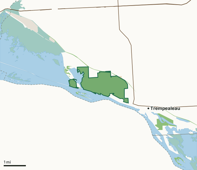
State wildlife areas, forests and other DNR landNational wildlife refuges and waterfowl production areasState parksLand trusts and other open landPerrot State ParkCounty lineLakeHighway
| Size | 1,262 acres in 5 pieces |
|---|---|
| County | Trempealeau County |
| Deer Management Unit | Trempealeau County |
| Public access (DNR) | Open to Hiking, Fishing, Hunting and Trapping |
| DNR property page | Perrot |
| Nearest towns | Trempealeau (next to it), Galesville (6 mi) and Dodge (8 mi) |
What is Perrot State Park like?
Perrot State Park is nestled among 500-foot bluffs where the Trempealeau and Mississippi rivers meet. Enjoy breathtaking river views from the hiking trails in this park, known for its natural, archaeological, and historical resources. There is direct access for bicyclists from the campground to the 24-mile Great River State Trail. There is also a marked canoe trail in Trempealeau Bay. Canoes can be rented at the park in season.
In the DNR's words, from its page for the property.
What are the rules on Perrot State Park?
The DNR's property map lists Perrot State Park as "Open to Hiking, Fishing, Hunting and Trapping". Hunting follows Wisconsin's statewide seasons and the rules posted on the property.
In Wisconsin state parks and recreation areas, hunting is limited to the seasons and the parts of the property the DNR sets for each one; the DNR's page has the details.
How many deer are taken around Perrot State Park?
Perrot State Park lies in Trempealeau County. The DNR registered 7,151 deer in Trempealeau County in 2025, against 6,627 in 2024.
| DMU | Perrot State Park acres in it | Deer, 2025 | Deer, 2024 | Deer, 2023 |
|---|---|---|---|---|
| Trempealeau County | 1,262 | 7,151 | 6,627 | 6,360 |
Harvest for the whole deer management unit, not the property alone: Wisconsin DNR Deer Metrics (registered harvest by deer management unit).
How do you get to Perrot State Park?
Nearest towns: Trempealeau (next to it), Galesville (6 miles), Dodge (8 miles) and Brice Prairie (8 miles). Highways within 5 miles: WI 35, WI 54 and WI 93.
What other public land is near Perrot State Park?
DNR properties within 10 miles:
- Great River State Trail: 255 acres, next to it
- Trempealeau Lakes Fishery Area: 169 acres, 1.4 miles away
- Mississippi Islands Wildlife Area: 59 acres, 3.2 miles away
- Van Loon Wildlife Area: 4,048 acres, 5 miles away
Public land within 3 miles of Perrot State Park
Counting Perrot State Park itself, 5,206 of the 33,521 acres within 3 miles of its boundary are public land open to the public (15.5%), by USGS PAD-US 4.1 (fee land open to the public).
| Manager | Acres within 3 miles |
|---|---|
| National wildlife refuges and waterfowl production areas | 3,448 |
| State wildlife areas, forests and other DNR land | 1,605 |
| Land trusts and other open land | 132 |
| State parks | 21 |
Questions hunters ask
Where is Perrot State Park?
In Trempealeau County, next to Trempealeau. The DNR's property page has its maps and parking.
Is Perrot State Park open to hunting?
Yes. The DNR's property map lists it as "Open to Hiking, Fishing, Hunting and Trapping". Posted refuges or closed areas, where there are any, are marked on site.
Which deer management unit is Perrot State Park in?
Trempealeau County.
How much public land is around Perrot State Park?
5,206 acres within 3 miles of its boundary, Perrot State Park included, by PAD-US 4.1. The closest other DNR property is Great River State Trail (next to it).
Get a Wisconsin hunt plan when they open
Hunt plans for Wisconsin are coming. Join the list and you'll hear first. The first 50 hunters in each new state get their plan free.
Until then, the free FilledTag app for iPhone has a map that works in every state, Wisconsin included.
Where these facts come from
- Area description, species, rules and directions: DNR, Perrot State Park; Wisconsin DNR managed lands open to hunting.
- Boundary and acres: the DNR's map layer above. Surrounding public land: USGS PAD-US 4.1 (fee land open to the public).
- Deer harvest: Wisconsin DNR Deer Metrics (registered harvest by deer management unit).
FilledTag is not part of the Wisconsin Department of Natural Resources. Check the DNR's rules and posted signs before you go.