Peshtigo Brook Wildlife Area: hunting and access
Peshtigo Brook Wildlife Area is 2,238 acres of land managed by the Wisconsin DNR in Oconto County, 6 miles from Suring. Hunters registered 7,277 deer in DMU Oconto in 2025.
Data updated October 2026. Area facts: the DNR's DNR property data, read 2026-10. Harvest: DNR Deer Metrics.
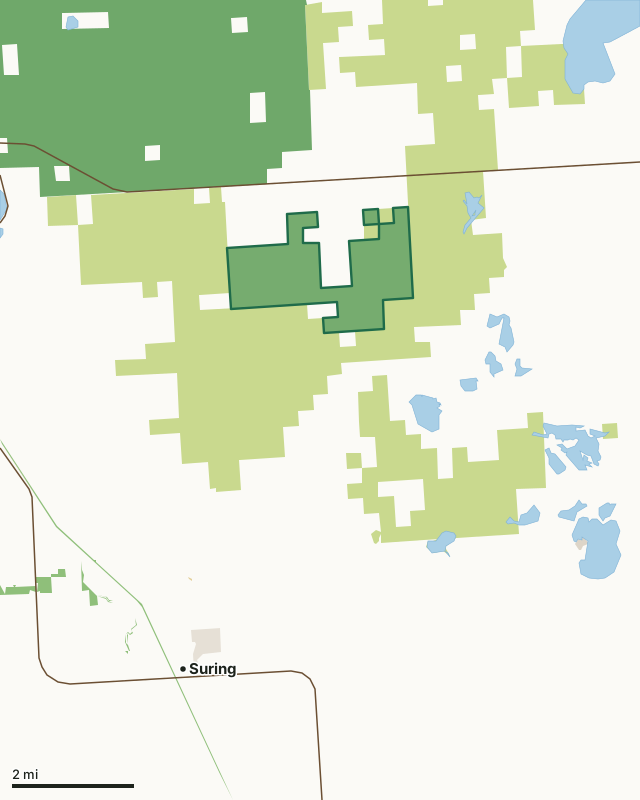
State wildlife areas, forests and other DNR landCounty forestNational forestOther federal landState parksOther county, city and regional landLand trusts and other open landPeshtigo Brook Wildlife AreaCounty lineLakeHighway
| Size | 2,238 acres in 2 pieces |
|---|---|
| County | Oconto County |
| Deer Management Unit | DMU Oconto |
| Public access (DNR) | Open to Hiking, Fishing, Hunting and Trapping |
| DNR property page | Peshtigo Brook Wildlife Area |
| Nearest towns | Suring (6 mi), Mountain (9 mi) and Coleman (12 mi) |
What is Peshtigo Brook Wildlife Area like?
Peshtigo Brook Wildlife Area is a 2,373-acre property in Oconto County. Approximately two-thirds of the property is Peshtigo Brook Meadow and Woods State Natural Area. This area has extensive, unique native sedge meadows interspersed with dry oak, pine, and aspen forests. It provides excellent remote hunting, trapping, and wildlife-viewing recreation. The property is north of Suring and south of Highway 64. Take Hawthorn Road from Pipeline Road to a parking area on the property's southwest corner. A single parking lot is provided. Remote country recreation skills are a must for the limited development of this property.
State ownership of the property began in 1953, with the original management directed toward waterfowls and sharp-tailed grouses. With changes in hydrology and the succession of land cover, management has shifted to an emphasis on wildlife and the unique sedge meadow community. Timber sales in the area improve habitat for wildlife dependent on early successional forest types. Prescribed burns to control brush in the sedge meadows are conducted periodically. Oak Wilt containment measures have been utilized here. Timber stand improvement plans, and treatments for invasive species treatments are planned for the future. The road system is maintained for management activities but is not currently open to vehicular traffic. Plans include improving access and parking through agreements with the Town and County.
In the DNR's words, from its page for the property.
What are the rules on Peshtigo Brook Wildlife Area?
The DNR's property map lists Peshtigo Brook Wildlife Area as "Open to Hiking, Fishing, Hunting and Trapping". Hunting follows Wisconsin's statewide seasons and the rules posted on the property.
Activities the DNR lists for Peshtigo Brook Wildlife Area: Birding, Cross-country skiing (no designated trail), Hiking (no designated trail), Hunting, Trapping, Wild edibles/gathering and Wildlife viewing.
How many deer are taken around Peshtigo Brook Wildlife Area?
Peshtigo Brook Wildlife Area lies in DMU Oconto. The DNR registered 7,277 deer in DMU Oconto in 2025.
| DMU | Peshtigo Brook Wildlife Area acres in it | Deer, 2025 |
|---|---|---|
| DMU Oconto | 2,238 | 7,277 |
Harvest for the whole deer management unit, not the property alone: Wisconsin DNR Deer Metrics (registered harvest by deer management unit).
How do you get to Peshtigo Brook Wildlife Area?
Nearest towns: Suring (6 miles), Mountain (9 miles), Coleman (12 miles) and Pound (12 miles). Highways within 5 miles: WI 64 and WI 32.
What other public land is near Peshtigo Brook Wildlife Area?
DNR properties within 10 miles:
- Nicolet State Trail: 1,334 acres, 4.3 miles away
- South Branch Oconto River Fishery Area: 609 acres, 4.8 miles away
- Montana Lake Fishery Area: 98 acres, 8.1 miles away
- North Branch Beaver Creek Fishery Area: 1,150 acres, 8.8 miles away
Public land within 3 miles of Peshtigo Brook Wildlife Area
Counting Peshtigo Brook Wildlife Area itself, 20,596 of the 38,484 acres within 3 miles of its boundary are public land open to the public (53.5%), by USGS PAD-US 4.1 (fee land open to the public).
| Manager | Acres within 3 miles |
|---|---|
| County forest | 13,639 |
| National forest | 4,717 |
| State wildlife areas, forests and other DNR land | 2,240 |
Questions hunters ask
Where is Peshtigo Brook Wildlife Area?
In Oconto County, 6 miles from Suring. The DNR's property page has its maps and parking.
Is Peshtigo Brook Wildlife Area open to hunting?
Yes. The DNR's property map lists it as "Open to Hiking, Fishing, Hunting and Trapping". Posted refuges or closed areas, where there are any, are marked on site.
Which deer management unit is Peshtigo Brook Wildlife Area in?
DMU Oconto.
How much public land is around Peshtigo Brook Wildlife Area?
20,596 acres within 3 miles of its boundary, Peshtigo Brook Wildlife Area included, by PAD-US 4.1. The closest other DNR property is Nicolet State Trail (4.3 miles).
Get a Wisconsin hunt plan when they open
Hunt plans for Wisconsin are coming. Join the list and you'll hear first. The first 50 hunters in each new state get their plan free.
Until then, the free FilledTag app for iPhone has a map that works in every state, Wisconsin included.
Where these facts come from
- Area description, species, rules and directions: DNR, Peshtigo Brook Wildlife Area; Wisconsin DNR managed lands open to hunting.
- Boundary and acres: the DNR's map layer above. Surrounding public land: USGS PAD-US 4.1 (fee land open to the public).
- Deer harvest: Wisconsin DNR Deer Metrics (registered harvest by deer management unit).
FilledTag is not part of the Wisconsin Department of Natural Resources. Check the DNR's rules and posted signs before you go.