South Branch Oconto River Fishery Area: hunting and access
South Branch Oconto River Fishery Area is 609 acres of land managed by the Wisconsin DNR in Oconto County, next to Suring. The DNR's page for it names deer and small game among the game here. Hunters registered 7,277 deer in DMU Oconto in 2025.
Data updated October 2026. Area facts: the DNR's DNR property data, read 2026-10. Harvest: DNR Deer Metrics.
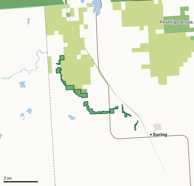
State wildlife areas, forests and other DNR landCounty forestNational forestOther federal landState parksLand trusts and other open landSouth Branch Oconto River Fishery AreaCounty lineLakeHighway
| Size | 609 acres in 22 pieces |
|---|---|
| County | Oconto County |
| Deer Management Unit | DMU Oconto, DMU 126 |
| DNR lists for hunting | deer and small game |
| Public access (DNR) | Open to Hiking, Fishing, Hunting and Trapping |
| DNR property page | South Branch Oconto River Fishery Area |
| Nearest towns | Suring (next to it), Mountain (8 mi) and Gillett (9 mi) |
What is South Branch Oconto River Fishery Area like?
The South Branch Oconto River originates from several branches in Oconto and Langlade Counties. After they combine, the stream then dips briefly into Menominee County. The Fishery Areas commences almost at the Menominee-Oconto County line and includes 11 miles of stream to where the north and south branches of the Oconto River merge immediately above Suring. The combined streams form the main Oconto River which flows directly into Green Bay as part of the Great Lakes drainage basin. By the time the South Branch Oconto River reaches the Fishery Area, the stream averages over 50 feet in width. Despite the great distance from its origins, the water in the stream during the summer throughout the Fishery Area is ideal for the growth of trout. Natural reproduction of brook trout takes place as well as brown trout to a more limited extent.
The South Branch Oconto River Fishery Area is northwest of Suring in Oconto County. There are several access/parking locations throughout the Fishery Area. The fish population is characteristic of a cold water fishery. In addition to brook and brown trout, some forage and rough fish have been observed. The most common species are the mottled sculpin, white sucker, hog sucker, longnose dace, blacknose dace, and pearl dace. The South Branch Oconto River Fishery Area is managed to preserve, protect, and enhance the high quality fishery and habitat for a variety of recreational and educational opportunities.
In the DNR's words, from its page for the property.
What can you hunt on South Branch Oconto River Fishery Area?
The DNR's page for South Branch Oconto River Fishery Area names deer and small game. Each follows Wisconsin's statewide season and, for deer, the tags and rules of the deer management unit.
What are the rules on South Branch Oconto River Fishery Area?
The DNR's property map lists South Branch Oconto River Fishery Area as "Open to Hiking, Fishing, Hunting and Trapping". Hunting follows Wisconsin's statewide seasons and the rules posted on the property.
Activities the DNR lists for South Branch Oconto River Fishery Area: Hunting - deer, fowl, and small game, Trapping, Hiking, Snowmobiling trail and Cross-country skiing.
How many deer are taken around South Branch Oconto River Fishery Area?
South Branch Oconto River Fishery Area lies in 2 deer management units. The DNR registered 7,277 deer in DMU Oconto in 2025.
| DMU | South Branch Oconto River Fishery Area acres in it | Deer, 2025 |
|---|---|---|
| DMU Oconto | 607 | 7,277 |
| DMU 126 | 1 | 3,288 |
Harvest for the whole deer management unit, not the property alone: Wisconsin DNR Deer Metrics (registered harvest by deer management unit).
How do you get to South Branch Oconto River Fishery Area?
Nearest towns: Suring (next to it), Mountain (8 miles), Gillett (9 miles) and Legend Lake (10 miles). Highways within 5 miles: WI 32 and WI 64.
What other public land is near South Branch Oconto River Fishery Area?
DNR properties within 10 miles:
- Nicolet State Trail: 1,334 acres, next to it
- Peshtigo Brook Wildlife Area: 2,238 acres, 4.8 miles away
- Upper Wolf River Fishery Area: 9,345 acres, 9.8 miles away
Public land within 3 miles of South Branch Oconto River Fishery Area
Counting South Branch Oconto River Fishery Area itself, 6,432 of the 47,985 acres within 3 miles of its boundary are public land open to the public (13.4%), by USGS PAD-US 4.1 (fee land open to the public).
| Manager | Acres within 3 miles |
|---|---|
| County forest | 5,424 |
| State wildlife areas, forests and other DNR land | 868 |
| Land trusts and other open land | 130 |
| National forest | 4 |
| State parks | 4 |
| Other federal land | 2 |
Questions hunters ask
Where is South Branch Oconto River Fishery Area?
In Oconto County, next to Suring. The DNR's property page has its maps and parking.
Is South Branch Oconto River Fishery Area open to hunting?
Yes. The DNR's property map lists it as "Open to Hiking, Fishing, Hunting and Trapping". Posted refuges or closed areas, where there are any, are marked on site.
Which deer management unit is South Branch Oconto River Fishery Area in?
DMU Oconto (607 acres) and DMU 126 (1 acres).
How much public land is around South Branch Oconto River Fishery Area?
6,432 acres within 3 miles of its boundary, South Branch Oconto River Fishery Area included, by PAD-US 4.1. The closest other DNR property is Nicolet State Trail (next to it).
Get a Wisconsin hunt plan when they open
Hunt plans for Wisconsin are coming. Join the list and you'll hear first. The first 50 hunters in each new state get their plan free.
Until then, the free FilledTag app for iPhone has a map that works in every state, Wisconsin included.
Where these facts come from
- Area description, species, rules and directions: DNR, South Branch Oconto River Fishery Area; Wisconsin DNR managed lands open to hunting.
- Boundary and acres: the DNR's map layer above. Surrounding public land: USGS PAD-US 4.1 (fee land open to the public).
- Deer harvest: Wisconsin DNR Deer Metrics (registered harvest by deer management unit).
FilledTag is not part of the Wisconsin Department of Natural Resources. Check the DNR's rules and posted signs before you go.