Pierce Co Islands Wildlife Area: hunting and access
Pierce Co Islands Wildlife Area is 1,273 acres of land managed by the Wisconsin DNR in Pierce County, next to Bay City. Hunters registered 4,366 deer in Pierce County in 2025.
Data updated October 2026. Area facts: the DNR's DNR property data, read 2026-10. Harvest: DNR Deer Metrics.
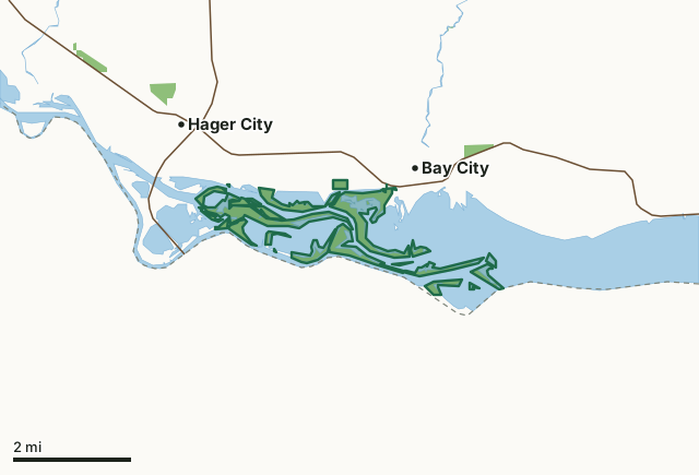
State wildlife areas, forests and other DNR landPierce Co Islands Wildlife AreaCounty lineLakeHighway
| Size | 1,273 acres in 24 pieces |
|---|---|
| County | Pierce County |
| Deer Management Unit | Pierce County |
| Public access (DNR) | Open to Hiking, Fishing, Hunting and Trapping |
| DNR property page | Pierce County Islands Wildlife Area |
| Nearest towns | Bay City (next to it), Hager City (next to it) and Maiden Rock (6 mi) |
What is Pierce Co Islands Wildlife Area like?
A 125-acre portion of Pierce County Islands Wildlife Area is temporary closed to all recreation activities until construction ends in 2027. The temporary closure includes the newly constructed islands, the southern portion of Pierce County Islands and Catherine’s Pass. The closure is to ensure safety around the construction site and to minimize erosion to the newly constructed islands and shorelines. Check out the map of the closed area if you plan to visit the property.
Pierce County Islands Wildlife Area is a 958-acre property on the Mississippi River in Pierce County. The acquisition of the property started with Pierce County donating land to the state in 1968. Additional acreage was purchased around the original land, including a 20-acre donation from the William Murray family, to bring the total acreage to what it is today. This unique property includes numerous islands and wetland habitats of the Mississippi River and includes a no-entry waterfowl refuge. The property is located on the Mississippi River outside of Bay City. Access to the islands is restricted to boat traffic, with a boat landing available in Bay City. The property is managed to provide opportunities for public hunting, trapping, wildlife observation and other nature-based outdoor recreation. Management objectives aim to maintain the floodplain forests associated with the islands.
In the DNR's words, from its page for the property.
What are the rules on Pierce Co Islands Wildlife Area?
The DNR's property map lists Pierce Co Islands Wildlife Area as "Open to Hiking, Fishing, Hunting and Trapping". Hunting follows Wisconsin's statewide seasons and the rules posted on the property.
Activities the DNR lists for Pierce Co Islands Wildlife Area: Birding;, Cross-country skiing (no designated trail);, Falconry (by permit);, Hiking;, Hunting;, Snowshoeing;, Trapping;, Wild edible/gathering; and and Wildlife viewing.
How many deer are taken around Pierce Co Islands Wildlife Area?
Pierce Co Islands Wildlife Area lies in Pierce County. The DNR registered 4,366 deer in Pierce County in 2025, against 3,766 in 2024.
| DMU | Pierce Co Islands Wildlife Area acres in it | Deer, 2025 | Deer, 2024 | Deer, 2023 |
|---|---|---|---|---|
| Pierce County | 1,273 | 4,366 | 3,766 | 3,718 |
Harvest for the whole deer management unit, not the property alone: Wisconsin DNR Deer Metrics (registered harvest by deer management unit).
How do you get to Pierce Co Islands Wildlife Area?
Nearest towns: Bay City (next to it), Hager City (next to it), Maiden Rock (6 miles) and Diamond Bluff (6 miles). Highways within 5 miles: WI 35 and US 63.
What other public land is near Pierce Co Islands Wildlife Area?
DNR properties within 10 miles:
- Bay City Mine State Natural Area: 48 acres, 1.3 miles away
- Trenton Bluff Prairie State Natural Area: 113 acres, 1.6 miles away
- Rush River Delta State Natural Area: 175 acres, 4.2 miles away
- Morgan Coulee Prairie State Natural Area: 58 acres, 6.2 miles away
- Maiden Rock Bluff State Natural Area: 263 acres, 7.5 miles away
Public land within 3 miles of Pierce Co Islands Wildlife Area
Counting Pierce Co Islands Wildlife Area itself, 1,438 of the 44,342 acres within 3 miles of its boundary are public land open to the public (3.2%), by USGS PAD-US 4.1 (fee land open to the public).
| Manager | Acres within 3 miles |
|---|---|
| State wildlife areas, forests and other DNR land | 1,438 |
Questions hunters ask
Where is Pierce Co Islands Wildlife Area?
In Pierce County, next to Bay City. The DNR's property page has its maps and parking.
Is Pierce Co Islands Wildlife Area open to hunting?
Yes. The DNR's property map lists it as "Open to Hiking, Fishing, Hunting and Trapping". Posted refuges or closed areas, where there are any, are marked on site.
Which deer management unit is Pierce Co Islands Wildlife Area in?
Pierce County.
How much public land is around Pierce Co Islands Wildlife Area?
1,438 acres within 3 miles of its boundary, Pierce Co Islands Wildlife Area included, by PAD-US 4.1. The closest other DNR property is Bay City Mine State Natural Area (1.3 miles).
Get a Wisconsin hunt plan when they open
Hunt plans for Wisconsin are coming. Join the list and you'll hear first. The first 50 hunters in each new state get their plan free.
Until then, the free FilledTag app for iPhone has a map that works in every state, Wisconsin included.
Where these facts come from
- Area description, species, rules and directions: DNR, Pierce Co Islands Wildlife Area; Wisconsin DNR managed lands open to hunting.
- Boundary and acres: the DNR's map layer above. Surrounding public land: USGS PAD-US 4.1 (fee land open to the public).
- Deer harvest: Wisconsin DNR Deer Metrics (registered harvest by deer management unit).
FilledTag is not part of the Wisconsin Department of Natural Resources. Check the DNR's rules and posted signs before you go.