Rush River Delta State Natural Area: hunting and access
Rush River Delta State Natural Area is 175 acres of land managed by the Wisconsin DNR in Pierce County, next to Maiden Rock. Hunters registered 4,366 deer in Pierce County in 2025.
Data updated October 2026. Area facts: the DNR's DNR property data, read 2026-10. Harvest: DNR Deer Metrics.
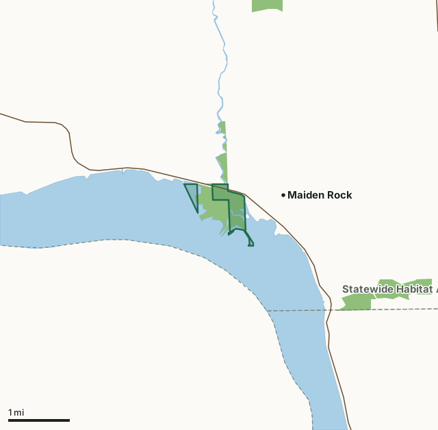
State wildlife areas, forests and other DNR landRush River Delta State Natural AreaCounty lineLakeHighway
| Size | 175 acres in 4 pieces |
|---|---|
| County | Pierce County |
| Deer Management Unit | Pierce County |
| Public access (DNR) | Open to Hiking, Fishing, Hunting and Trapping |
| DNR property page | Rush River Delta |
| Nearest towns | Maiden Rock (next to it), Stockholm (5 mi) and Bay City (6 mi) |
What is Rush River Delta State Natural Area like?
Rush River Delta protects a floodplain forest on the alluvial plain at the mouth of the Rush River where it empties into the Mississippi River's Lake Pepin. The area supports stands of lowland hardwoods including silver maple, cottonwood, willow, American elm, and green ash. Large patches of wood nettle dominate the ground layer. Several open, wet depressions are vegetated with river bulrush and smartweed and provide excellent spawning habitat for northern pike and rearing areas for mallards and wood ducks. A sand spit extends into Lake Pepin at the Rush River mouth and provides feeding and nesting areas for shorebirds. Woodland birds include yellow-throated vireo, warbling vireo, blue-gray gnatcatcher, American redstart, and northern oriole. Rush River Delta is owned by the DNR and was designated a State Natural Area in 1986.
Pierce County. T24N-R16W, Section 16, 17. 400 acres. From the intersection of State Highway 35 and County Highway S in Maiden Rock, go west on 35 1.3 miles to a parking area at the junction of County A. The natural area lies south of Highway 35.
In the DNR's words, from its page for the property.
What are the rules on Rush River Delta State Natural Area?
The DNR's property map lists Rush River Delta State Natural Area as "Open to Hiking, Fishing, Hunting and Trapping". Hunting follows Wisconsin's statewide seasons and the rules posted on the property.
How many deer are taken around Rush River Delta State Natural Area?
Rush River Delta State Natural Area lies in Pierce County. The DNR registered 4,366 deer in Pierce County in 2025, against 3,766 in 2024.
| DMU | Rush River Delta State Natural Area acres in it | Deer, 2025 | Deer, 2024 | Deer, 2023 |
|---|---|---|---|---|
| Pierce County | 175 | 4,366 | 3,766 | 3,718 |
Harvest for the whole deer management unit, not the property alone: Wisconsin DNR Deer Metrics (registered harvest by deer management unit).
How do you get to Rush River Delta State Natural Area?
Nearest towns: Maiden Rock (next to it), Stockholm (5 miles), Bay City (6 miles) and Plum City (8 miles). Highways within 5 miles: WI 35, WI 530 and WI 183.
What other public land is near Rush River Delta State Natural Area?
DNR properties within 10 miles:
- Morgan Coulee Prairie State Natural Area: 58 acres, 2.8 miles away
- Maiden Rock Bluff State Natural Area: 263 acres, 3.6 miles away
- Pierce Co Islands Wildlife Area: 1,273 acres, 4.2 miles away
- Bay City Mine State Natural Area: 48 acres, 4.4 miles away
Public land within 3 miles of Rush River Delta State Natural Area
Counting Rush River Delta State Natural Area itself, 674 of the 25,054 acres within 3 miles of its boundary are public land open to the public (2.7%), by USGS PAD-US 4.1 (fee land open to the public).
| Manager | Acres within 3 miles |
|---|---|
| State wildlife areas, forests and other DNR land | 674 |
Questions hunters ask
Where is Rush River Delta State Natural Area?
In Pierce County, next to Maiden Rock. The DNR's property page has its maps and parking.
Is Rush River Delta State Natural Area open to hunting?
Yes. The DNR's property map lists it as "Open to Hiking, Fishing, Hunting and Trapping". Posted refuges or closed areas, where there are any, are marked on site.
Which deer management unit is Rush River Delta State Natural Area in?
Pierce County.
How much public land is around Rush River Delta State Natural Area?
674 acres within 3 miles of its boundary, Rush River Delta State Natural Area included, by PAD-US 4.1. The closest other DNR property is Morgan Coulee Prairie State Natural Area (2.8 miles).
Get a Wisconsin hunt plan when they open
Hunt plans for Wisconsin are coming. Join the list and you'll hear first. The first 50 hunters in each new state get their plan free.
Until then, the free FilledTag app for iPhone has a map that works in every state, Wisconsin included.
Where these facts come from
- Area description, species, rules and directions: DNR, Rush River Delta State Natural Area; Wisconsin DNR managed lands open to hunting.
- Boundary and acres: the DNR's map layer above. Surrounding public land: USGS PAD-US 4.1 (fee land open to the public).
- Deer harvest: Wisconsin DNR Deer Metrics (registered harvest by deer management unit).
FilledTag is not part of the Wisconsin Department of Natural Resources. Check the DNR's rules and posted signs before you go.