Pine River System Fishery Area: hunting and access
Pine River System Fishery Area is 2,085 acres of land managed by the Wisconsin DNR in Waushara County, next to Wild Rose. Hunters registered 8,678 deer in Waushara County in 2025.
Data updated October 2026. Area facts: the DNR's DNR property data, read 2026-10. Harvest: DNR Deer Metrics.
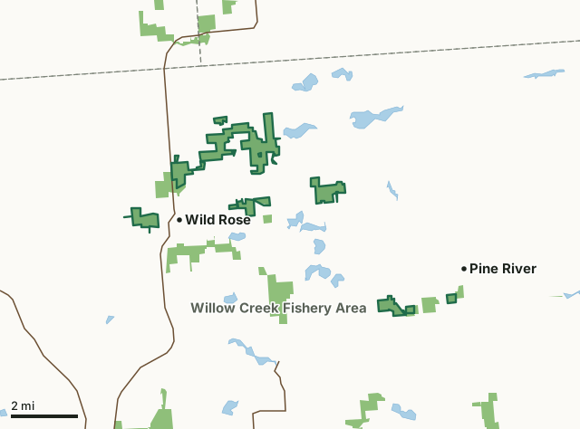
State wildlife areas, forests and other DNR landPine River System Fishery AreaCounty lineLakeHighway
| Size | 2,085 acres in 12 pieces |
|---|---|
| County | Waushara County |
| Deer Management Unit | Waushara County |
| Public access (DNR) | Open to Hiking, Fishing, Hunting and Trapping |
| DNR property page | Pine River System Fishery Area |
| Nearest towns | Wild Rose (next to it), Pine River (next to it) and Poy Sippi (4 mi) |
What is Pine River System Fishery Area like?
The Pine River System Fishery Area includes the most productive trout water on the Pine River and its major tributary streams. The Pine River Fishery Area is composed of the Pine River and seven tributaries: Lower Pine, Jones, Davis, Clayton, Upper Pine, Kaminski, and Little Silver Creeks in Waushara County. These streams are quality trout waters. The waters are generally crystal clear. There have been numerous stream bank improvement projects throughout the system, enhancing the already excellent fishing opportunities. DNR owns 2,090 acres of fragmented parcels stretched along the stream corridors. Public access is a substantial land area following the Pine River Watershed as it flows through much of northern Waushara County. Generally, the Pine is split into the Upper Pine River (above the Wild Rose Millpond) and the Lower Pine River (below the Wild Rose Millpond).
The name "Waushara" is an English derivation of an Indian word meaning "Good Earth." The surface waters of natural lakes and streams are a product of the land, and "good trout fishing" is synonymous with the good waters of this fishery area. The vegetative cover is rich with diversity, with a large portion being lowland brush and swamp hardwoods to upland forests and grasslands. Additionally, many old agricultural fields have been abandoned and are reverting to natural vegetation; others have been planted into pine plantations, converted into native prairies, or continued to be farmed in share-crop agreements. This unique mix of woods, water and fields provides prime habitat for a variety of game and non-game species, offering a pleasant satisfaction to all who visit this natural and beautiful area. Amphibians sampled on fishery surveys include green and leopard frogs and spring peepers.
In the DNR's words, from its page for the property.
What are the rules on Pine River System Fishery Area?
The DNR's property map lists Pine River System Fishery Area as "Open to Hiking, Fishing, Hunting and Trapping". Hunting follows Wisconsin's statewide seasons and the rules posted on the property.
Activities the DNR lists for Pine River System Fishery Area: Hunting, Trapping, Hiking, Snowmobiling trail (designated areas only) and Wildlife viewing.
How many deer are taken around Pine River System Fishery Area?
Pine River System Fishery Area lies in Waushara County. The DNR registered 8,678 deer in Waushara County in 2025, against 8,191 in 2024.
| DMU | Pine River System Fishery Area acres in it | Deer, 2025 | Deer, 2024 | Deer, 2023 |
|---|---|---|---|---|
| Waushara County | 2,085 | 8,678 | 8,191 | 6,404 |
Harvest for the whole deer management unit, not the property alone: Wisconsin DNR Deer Metrics (registered harvest by deer management unit).
How do you get to Pine River System Fishery Area?
Nearest towns: Wild Rose (next to it), Pine River (next to it), Poy Sippi (4 miles) and Redgranite (5 miles). Highways within 5 miles: WI 22, WI 73, WI 49 and WI 152.
What other public land is near Pine River System Fishery Area?
DNR properties within 10 miles:
- Wild Rose Hatchery: 245 acres, next to it
- Karner Blue Meadow State Natural Area: 41 acres, next to it
- Willow Creek Fishery Area: 2,864 acres, 0.7 miles away
- Radley Creek Fishery Area: 1,438 acres, 2.2 miles away
- State Ice Age Trail Area (SIATA): 4,676 acres, 3.6 miles away
Public land within 3 miles of Pine River System Fishery Area
Counting Pine River System Fishery Area itself, 4,083 of the 78,192 acres within 3 miles of its boundary are public land open to the public (5.2%), by USGS PAD-US 4.1 (fee land open to the public).
| Manager | Acres within 3 miles |
|---|---|
| State wildlife areas, forests and other DNR land | 4,081 |
| Land trusts and other open land | 2 |
Questions hunters ask
Where is Pine River System Fishery Area?
In Waushara County, next to Wild Rose. The DNR's property page has its maps and parking.
Is Pine River System Fishery Area open to hunting?
Yes. The DNR's property map lists it as "Open to Hiking, Fishing, Hunting and Trapping". Posted refuges or closed areas, where there are any, are marked on site.
Which deer management unit is Pine River System Fishery Area in?
Waushara County.
How much public land is around Pine River System Fishery Area?
4,083 acres within 3 miles of its boundary, Pine River System Fishery Area included, by PAD-US 4.1. The closest other DNR property is Wild Rose Hatchery (next to it).
Get a Wisconsin hunt plan when they open
Hunt plans for Wisconsin are coming. Join the list and you'll hear first. The first 50 hunters in each new state get their plan free.
Until then, the free FilledTag app for iPhone has a map that works in every state, Wisconsin included.
Where these facts come from
- Area description, species, rules and directions: DNR, Pine River System Fishery Area; Wisconsin DNR managed lands open to hunting.
- Boundary and acres: the DNR's map layer above. Surrounding public land: USGS PAD-US 4.1 (fee land open to the public).
- Deer harvest: Wisconsin DNR Deer Metrics (registered harvest by deer management unit).
FilledTag is not part of the Wisconsin Department of Natural Resources. Check the DNR's rules and posted signs before you go.