Radley Creek Fishery Area: hunting and access
Radley Creek Fishery Area is 1,438 acres of land managed by the Wisconsin DNR in Waupaca and Portage counties, 2 miles from Chain O' Lakes. The DNR's page for it names deer, wild turkey, ducks and geese and rabbits and squirrels among the game here. Hunters registered 10,740 deer in Waupaca County in 2025.
Data updated October 2026. Area facts: the DNR's DNR property data, read 2026-10. Harvest: DNR Deer Metrics.
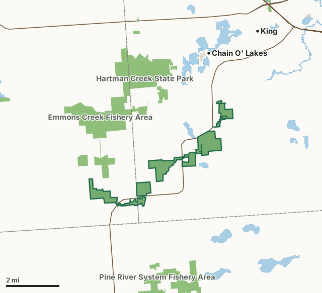
State wildlife areas, forests and other DNR landOther county, city and regional landRadley Creek Fishery AreaCounty lineLakeHighway
| Size | 1,438 acres in 6 pieces |
|---|---|
| Counties | Waupaca County and Portage County |
| Deer Management Unit | Waupaca County, Portage County |
| DNR lists for hunting | deer, wild turkey, ducks and geese and rabbits and squirrels |
| Public access (DNR) | Open to Hiking, Fishing, Hunting and Trapping |
| DNR property page | Radley Creek Fishery Area |
| Nearest towns | Chain O' Lakes (2 mi), King (3 mi) and Waupaca (5 mi) |
What is Radley Creek Fishery Area like?
Radley Creek Fishery Area is in the Central Sand Hills ecological landscape of southwestern Waupaca and southeastern Portage counties. Habitat types present include open grass fields, pine plantations, remnant oak savanna, red and white pine plantations, oak woods, and marsh. Upland grass and other herbaceous vegetation cover 312 acres. Alder and willow brush cover an additional 84 acres. The north branch (Murray Creek) and south branch (Pearl Creek) of the Radley begin in Portage County. These two main branches along with other smaller feeder streams join together to form Radley Creek in Waupaca County. The varied habitat on the fishery area provides homes for a wide range of both game and non-game species. Management of upland sites ranges from habitat improvement to benefit grassland nesting birds to habitat for the federally endangered Karner blue butterfly.
The Mud Lake - Radley Creek Savanna State Natural Area covers 100 acres of the Radley Creek Fishery Area. Mud Lake is a shallow, hard water lake in a wilderness setting - having no access or human-made developments. Radley Creek Fishery Area is located on State Hwy 22, six miles south of the intersection with US Hwy 10. did not include/did not use fishery area questionnaire. The Radley Creek Fishery Area is managed to provide trout fishing opportunities, protect spawning areas, enhance water quality, protect a wide variety of habitat types important to both game and non-game species, sustain forested areas, and provide a variety of outdoor based recreational and educational opportunities.
In the DNR's words, from its page for the property.
What can you hunt on Radley Creek Fishery Area?
The DNR's page for Radley Creek Fishery Area names deer, wild turkey, ducks and geese and rabbits and squirrels. Each follows Wisconsin's statewide season and, for deer, the tags and rules of the deer management unit.
What are the rules on Radley Creek Fishery Area?
The DNR's property map lists Radley Creek Fishery Area as "Open to Hiking, Fishing, Hunting and Trapping". Hunting follows Wisconsin's statewide seasons and the rules posted on the property.
Activities the DNR lists for Radley Creek Fishery Area: Hunting - white tailed deer, rabbits, squirrel, waterfowl, turkey, fox, coyote, raccoon, Trapping, Hiking, Snowmobiling trail, Cross-country skiing and Wildlife viewing.
How many deer are taken around Radley Creek Fishery Area?
Radley Creek Fishery Area lies in 2 deer management units. The DNR registered 10,740 deer in Waupaca County in 2025, against 10,349 in 2024.
| DMU | Radley Creek Fishery Area acres in it | Deer, 2025 | Deer, 2024 | Deer, 2023 |
|---|---|---|---|---|
| Waupaca County | 1,151 | 10,740 | 10,349 | 9,097 |
| Portage County | 286 | 8,384 | 7,641 | 6,559 |
Harvest for the whole deer management unit, not the property alone: Wisconsin DNR Deer Metrics (registered harvest by deer management unit).
How do you get to Radley Creek Fishery Area?
Nearest towns: Chain O' Lakes (2 miles), King (3 miles), Waupaca (5 miles) and Wild Rose (5 miles). Highways within 5 miles: WI 22, WI 54, US 10 and WI 49.
What other public land is near Radley Creek Fishery Area?
DNR properties within 10 miles:
- State Ice Age Trail Area (SIATA): 4,676 acres, next to it
- Emmons Creek Fishery Area: 1,468 acres, 1.4 miles away
- Hartman Creek State Park: 1,472 acres, 1.9 miles away
- Pine River System Fishery Area: 2,085 acres, 2.2 miles away
- Waupaca River Fishery Area: 79 acres, 3.7 miles away
- Wild Rose Hatchery: 245 acres, 3.8 miles away
Public land within 3 miles of Radley Creek Fishery Area
Counting Radley Creek Fishery Area itself, 4,463 of the 50,076 acres within 3 miles of its boundary are public land open to the public (8.9%), by USGS PAD-US 4.1 (fee land open to the public).
| Manager | Acres within 3 miles |
|---|---|
| State wildlife areas, forests and other DNR land | 4,434 |
| Other county, city and regional land | 26 |
| State parks | 3 |
Questions hunters ask
Where is Radley Creek Fishery Area?
In Waupaca and Portage counties, 2 miles from Chain O' Lakes. The DNR's property page has its maps and parking.
Is Radley Creek Fishery Area open to hunting?
Yes. The DNR's property map lists it as "Open to Hiking, Fishing, Hunting and Trapping". Posted refuges or closed areas, where there are any, are marked on site.
Which deer management unit is Radley Creek Fishery Area in?
Waupaca County (1,151 acres) and Portage County (286 acres).
How much public land is around Radley Creek Fishery Area?
4,463 acres within 3 miles of its boundary, Radley Creek Fishery Area included, by PAD-US 4.1. The closest other DNR property is State Ice Age Trail Area (SIATA) (next to it).
Get a Wisconsin hunt plan when they open
Hunt plans for Wisconsin are coming. Join the list and you'll hear first. The first 50 hunters in each new state get their plan free.
Until then, the free FilledTag app for iPhone has a map that works in every state, Wisconsin included.
Where these facts come from
- Area description, species, rules and directions: DNR, Radley Creek Fishery Area; Wisconsin DNR managed lands open to hunting.
- Boundary and acres: the DNR's map layer above. Surrounding public land: USGS PAD-US 4.1 (fee land open to the public).
- Deer harvest: Wisconsin DNR Deer Metrics (registered harvest by deer management unit).
FilledTag is not part of the Wisconsin Department of Natural Resources. Check the DNR's rules and posted signs before you go.
Wisconsin hunting Waupaca County Portage County Waupaca County Portage County