Pokegama Carnegie Wetlands State Natural Area: hunting and access
Pokegama Carnegie Wetlands State Natural Area is 311 acres of land managed by the Wisconsin DNR in Douglas County, next to Superior. Hunters registered 2,184 deer in DMU 102 in 2025.
Data updated October 2026. Area facts: the DNR's DNR property data, read 2026-10. Harvest: DNR Deer Metrics.
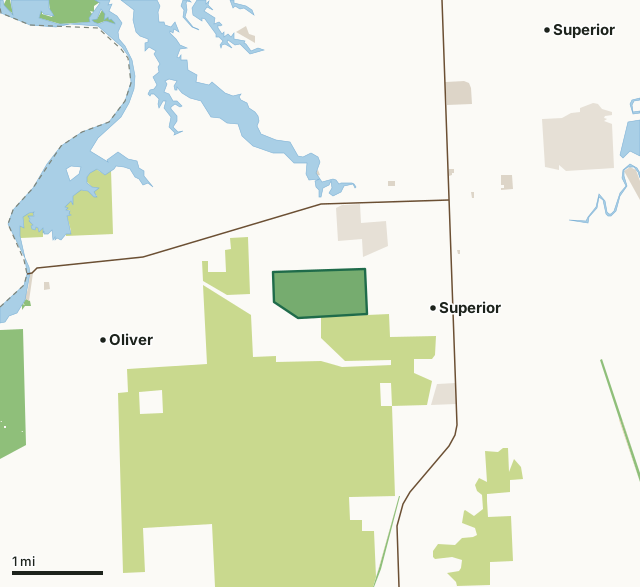
State wildlife areas, forests and other DNR landCounty forestState parksOther county, city and regional landLand trusts and other open landPokegama Carnegie Wetlands State Natural AreaCounty lineLakeHighway
| Size | 311 acres |
|---|---|
| County | Douglas County |
| Deer Management Unit | DMU 102 |
| Public access (DNR) | Open to Hiking, Fishing, Hunting and Trapping |
| DNR property page | Pokegama Carnegie Wetlands |
| Nearest towns | Superior (next to it), Oliver (2 mi) and Poplar (17 mi) |
What is Pokegama Carnegie Wetlands State Natural Area like?
Situated on level clay flats between the Pokegama and Little Pokegama Rivers, Pokegama Carnegie Wetlands features an extensive mosaic of wetland vegetation containing many rare plant species. A tall complex of shrub wetlands composed of speckled alder and willows has the greatest coverage with small patches of open sedge meadow dominated by coarse leaved sedges and blue joint grass also present. Widely scattered small pools support a variety of emergent and submergent aquatic plant species. Small "islands" of trees dot the wetland with tamarack, white pine, white spruce, red pine, trembling aspen, and balsam poplar. Of special significance are the numerous populations of rare plants occurring within the wetlands. Many are represented by large or multiple populations throughout the complex and some are not generally widespread within the Lake Superior region.
Douglas County. T48N-R14W, Sections 8, 9, 16, 17, 18, 19, 20, 21. 1,516 acres. From the intersection of State Highway 35 and 105 in Superior, go west on 105 for nearly 2 miles, then south on South Pokegama Road for 0.7 miles. Walk east into the site. To reach the Douglas County Forest SNA, from Highway 105 and County W (Chicago Avenue) in Oliver, go south on W for 2.7 miles, then north on E. Kimmes Road for 0.7 miles. Walk northeast 0.5 miles into the site. Pokegama Carnegie Wetlands is owned by: Douglas County and the Wisconsin DNR.
In the DNR's words, from its page for the property.
What are the rules on Pokegama Carnegie Wetlands State Natural Area?
The DNR's property map lists Pokegama Carnegie Wetlands State Natural Area as "Open to Hiking, Fishing, Hunting and Trapping". Hunting follows Wisconsin's statewide seasons and the rules posted on the property.
How many deer are taken around Pokegama Carnegie Wetlands State Natural Area?
Pokegama Carnegie Wetlands State Natural Area lies in DMU 102. The DNR registered 2,184 deer in DMU 102 in 2025.
| DMU | Pokegama Carnegie Wetlands State Natural Area acres in it | Deer, 2025 |
|---|---|---|
| DMU 102 | 311 | 2,184 |
Harvest for the whole deer management unit, not the property alone: Wisconsin DNR Deer Metrics (registered harvest by deer management unit).
How do you get to Pokegama Carnegie Wetlands State Natural Area?
Nearest towns: Superior (next to it), Oliver (2 miles), Poplar (17 miles) and Lake Nebagamon (23 miles). Highways within 5 miles: WI 35, WI 105 and US 2.
What other public land is near Pokegama Carnegie Wetlands State Natural Area?
DNR properties within 10 miles:
- Saunders State Trail: 143 acres, 2 miles away
- Wild Rivers State Trail: 1,158 acres, 2.6 miles away
- St Louis River Streambank Protection Area: 6,697 acres, 2.8 miles away
- Gandy Dancer State Trail: 880 acres, 4 miles away
- Nemadji River State North Country Trail Area: 177 acres, 5.7 miles away
- Black River State North Country Trail Area: 178 acres, 6 miles away
Public land within 3 miles of Pokegama Carnegie Wetlands State Natural Area
Counting Pokegama Carnegie Wetlands State Natural Area itself, 6,206 of the 23,963 acres within 3 miles of its boundary are public land open to the public (25.9%), by USGS PAD-US 4.1 (fee land open to the public).
| Manager | Acres within 3 miles |
|---|---|
| County forest | 5,266 |
| State wildlife areas, forests and other DNR land | 433 |
| Land trusts and other open land | 419 |
| Other county, city and regional land | 86 |
| State parks | 2 |
Questions hunters ask
Where is Pokegama Carnegie Wetlands State Natural Area?
In Douglas County, next to Superior. The DNR's property page has its maps and parking.
Is Pokegama Carnegie Wetlands State Natural Area open to hunting?
Yes. The DNR's property map lists it as "Open to Hiking, Fishing, Hunting and Trapping". Posted refuges or closed areas, where there are any, are marked on site.
Which deer management unit is Pokegama Carnegie Wetlands State Natural Area in?
DMU 102.
How much public land is around Pokegama Carnegie Wetlands State Natural Area?
6,206 acres within 3 miles of its boundary, Pokegama Carnegie Wetlands State Natural Area included, by PAD-US 4.1. The closest other DNR property is Saunders State Trail (2 miles).
Get a Wisconsin hunt plan when they open
Hunt plans for Wisconsin are coming. Join the list and you'll hear first. The first 50 hunters in each new state get their plan free.
Until then, the free FilledTag app for iPhone has a map that works in every state, Wisconsin included.
Where these facts come from
- Area description, species, rules and directions: DNR, Pokegama Carnegie Wetlands State Natural Area; Wisconsin DNR managed lands open to hunting.
- Boundary and acres: the DNR's map layer above. Surrounding public land: USGS PAD-US 4.1 (fee land open to the public).
- Deer harvest: Wisconsin DNR Deer Metrics (registered harvest by deer management unit).
FilledTag is not part of the Wisconsin Department of Natural Resources. Check the DNR's rules and posted signs before you go.