St Louis River Streambank Protection Area: hunting and access
St Louis River Streambank Protection Area is 6,697 acres of land managed by the Wisconsin DNR in Douglas County, next to Oliver. Hunters registered 2,184 deer in DMU 102 in 2025.
Data updated October 2026. Area facts: the DNR's DNR property data, read 2026-10. Harvest: DNR Deer Metrics.
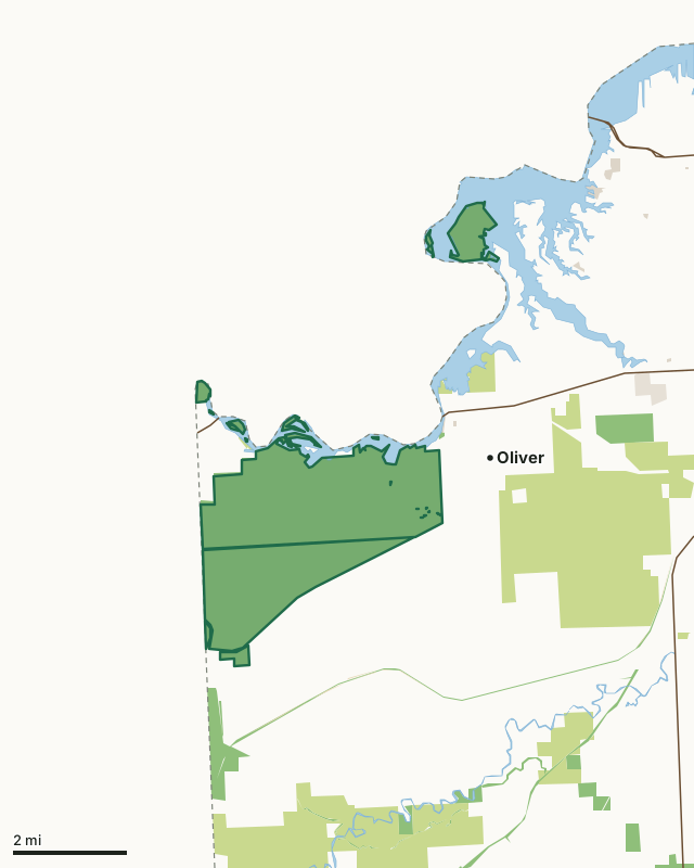
State wildlife areas, forests and other DNR landCounty forestState parksOther county, city and regional landLand trusts and other open landSt Louis River Streambank Protection AreaCounty lineLakeHighway
| Size | 6,697 acres in 15 pieces |
|---|---|
| County | Douglas County |
| Deer Management Unit | DMU 102 |
| Public access (DNR) | Open to Hiking, Fishing, Hunting and Trapping |
| DNR property page | St. Louis/Red River Stream Bank Protection Area |
| Nearest towns | Oliver (next to it), Superior (4 mi) and Poplar (20 mi) |
What is St Louis River Streambank Protection Area like?
The 7,000-acre St. Louis/Red River Stream Bank Protection Area was approved in 1994. It is characterized by steep dendritic ravines that flow into the Red River, or directly into the St. Louis River. More level areas exist between the ravines and are heavily wooded. Marshy areas may make travel difficult at times. The protection area encompasses 18 stream miles and 8 state-owned islands. The Red River gets its name from the red clay soils in the area. The Stream Bank Protection Area was purchased in order to prevent uses in these locations that would contribute to silt eroding into the river system.
Access to the protection area by land is extremely limited. Walk-in access is available from the south side of the property. The northern boundary of the property can be accessed by boat. The DNR operates a boat landing approximately 0.25 miles downstream in the Village of Oliver. The St. Louis River and Estuary and the Red River are critical habitats associated with the western arm of Lake Superior. In 2010, the National Oceanic and Atmospheric Administration (NOAA) accepted St. Louis River for the Lake Superior National Estuarine Research Reserve (NERR) [exit DNR]. The NERR System protects more than 1.3 million coastal and estuarine acres in 28 reserves located in 22 states and Puerto Rico for purposes of long-term research, environmental monitoring, education and stewardship. The St.
In the DNR's words, from its page for the property.
What are the rules on St Louis River Streambank Protection Area?
The DNR's property map lists St Louis River Streambank Protection Area as "Open to Hiking, Fishing, Hunting and Trapping". Hunting follows Wisconsin's statewide seasons and the rules posted on the property.
Activities the DNR lists for St Louis River Streambank Protection Area: Hunting, Trapping, Hiking, Cross-country skiing, Wildlife viewing and Fishing.
How many deer are taken around St Louis River Streambank Protection Area?
St Louis River Streambank Protection Area lies in DMU 102. The DNR registered 2,184 deer in DMU 102 in 2025.
| DMU | St Louis River Streambank Protection Area acres in it | Deer, 2025 |
|---|---|---|
| DMU 102 | 6,691 | 2,184 |
Harvest for the whole deer management unit, not the property alone: Wisconsin DNR Deer Metrics (registered harvest by deer management unit).
How do you get to St Louis River Streambank Protection Area?
Nearest towns: Oliver (next to it), Superior (4 miles), Poplar (20 miles) and Lake Nebagamon (26 miles). Highways within 5 miles: WI 35, WI 105, US 2, US 53 and I-535.
What other public land is near St Louis River Streambank Protection Area?
DNR properties within 10 miles:
- Clear Creek State North Country Trail Area: 357 acres, 0.5 miles away
- Saunders State Trail: 143 acres, 1 mile away
- Nemadji River State North Country Trail Area: 177 acres, 2.5 miles away
- Pokegama Carnegie Wetlands State Natural Area: 311 acres, 2.8 miles away
- Gandy Dancer State Trail: 880 acres, 4 miles away
- North Country Nat'l Scenic Trail: 22 acres, 4.2 miles away
Public land within 3 miles of St Louis River Streambank Protection Area
Counting St Louis River Streambank Protection Area itself, 11,013 of the 73,621 acres within 3 miles of its boundary are public land open to the public (15%), by USGS PAD-US 4.1 (fee land open to the public).
| Manager | Acres within 3 miles |
|---|---|
| State wildlife areas, forests and other DNR land | 7,279 |
| County forest | 3,612 |
| Other county, city and regional land | 94 |
| State parks | 25 |
| Other federal land | 3 |
Questions hunters ask
Where is St Louis River Streambank Protection Area?
In Douglas County, next to Oliver. The DNR's property page has its maps and parking.
Is St Louis River Streambank Protection Area open to hunting?
Yes. The DNR's property map lists it as "Open to Hiking, Fishing, Hunting and Trapping". Posted refuges or closed areas, where there are any, are marked on site.
Which deer management unit is St Louis River Streambank Protection Area in?
DMU 102.
How much public land is around St Louis River Streambank Protection Area?
11,013 acres within 3 miles of its boundary, St Louis River Streambank Protection Area included, by PAD-US 4.1. The closest other DNR property is Clear Creek State North Country Trail Area (0.5 miles).
Get a Wisconsin hunt plan when they open
Hunt plans for Wisconsin are coming. Join the list and you'll hear first. The first 50 hunters in each new state get their plan free.
Until then, the free FilledTag app for iPhone has a map that works in every state, Wisconsin included.
Where these facts come from
- Area description, species, rules and directions: DNR, St Louis River Streambank Protection Area; Wisconsin DNR managed lands open to hunting.
- Boundary and acres: the DNR's map layer above. Surrounding public land: USGS PAD-US 4.1 (fee land open to the public).
- Deer harvest: Wisconsin DNR Deer Metrics (registered harvest by deer management unit).
FilledTag is not part of the Wisconsin Department of Natural Resources. Check the DNR's rules and posted signs before you go.