Rat River Wildlife Area: hunting and access
Rat River Wildlife Area is 4,589 acres of land managed by the Wisconsin DNR in Winnebago and Outagamie counties, next to Winchester. The DNR's page for it names deer, wild turkey and small game among the game here. Hunters registered 2,895 deer in Winnebago County in 2025.
Data updated October 2026. Area facts: the DNR's DNR property data, read 2026-10. Harvest: DNR Deer Metrics.
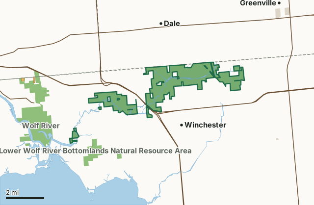
State wildlife areas, forests and other DNR landOther county, city and regional landVoluntary Public Access landRat River Wildlife AreaCounty lineLakeHighway
| Size | 4,589 acres in 9 pieces |
|---|---|
| Counties | Winnebago County and Outagamie County |
| Deer Management Unit | Winnebago County, Outagamie County |
| DNR lists for hunting | deer, wild turkey and small game |
| Public access (DNR) | Open to Hiking, Fishing, Hunting and Trapping |
| DNR property page | Rat River Wildlife Area |
| Nearest towns | Winchester (next to it), Dale (2 mi) and Greenville (4 mi) |
What is Rat River Wildlife Area like?
The state manages and owns the nearly 4,000-acre Rat River Wildlife Area is in Winnebago County. It is an extended, narrow property comprising two large segments and several smaller ones scattered along the Rat River, eventually flowing into the Wolf River. Historically, the area was comprised of sedge meadows and marshes, and this area was important to local businesses, which cut the sedges annually to make "wiregrass" rugs, packing material, and livestock bedding. Today, much of the property is dominated by canary grass with a dense population of cattails. Some lowland forest types are found in the wildlife area, as are a few upland fields.
The Rat River WA was originally established as a Fishery Management property in 1963 and became a Wildlife property in 1978. Past management focused on waterfowl habitat, creating potholes, managing cattails to increase diversity, planting nesting cover in upland fields and cutting marsh hay to control woody encroachment. Current management emphasizes maintaining swamp hardwoods and maintaining or restoring sedge meadows, marshes, and shrub swamps. Some hay cutting still occurs by permit and is used as a management tool for brush control and to provide migratory stopover habitat for waterfowl and shorebirds. You can find Rat River Wildlife Area north of Highways II and 110 between Winchester and Zittau. Parking areas are on North Loop Road, County Highway M, Hillcrest Road and Shady Lane.
In the DNR's words, from its page for the property.
What can you hunt on Rat River Wildlife Area?
The DNR's page for Rat River Wildlife Area names deer, wild turkey and small game. Each follows Wisconsin's statewide season and, for deer, the tags and rules of the deer management unit.
What are the rules on Rat River Wildlife Area?
The DNR's property map lists Rat River Wildlife Area as "Open to Hiking, Fishing, Hunting and Trapping". Hunting follows Wisconsin's statewide seasons and the rules posted on the property.
Activities the DNR lists for Rat River Wildlife Area: Birding, Canoeing, Cross-country skiing (no designated trail), Hiking (no designated trail), Hunting (noted for deer, turkey and small game), Kayaking, Snowmobiling trail, Trapping, Wild edibles/gathering and Wildlife viewing.
How many deer are taken around Rat River Wildlife Area?
Rat River Wildlife Area lies in 2 deer management units. The DNR registered 2,895 deer in Winnebago County in 2025, against 2,728 in 2024.
| DMU | Rat River Wildlife Area acres in it | Deer, 2025 | Deer, 2024 | Deer, 2023 |
|---|---|---|---|---|
| Winnebago County | 4,589 | 2,895 | 2,728 | 2,280 |
| Outagamie County | 4 | 4,322 | 4,318 | 3,847 |
Harvest for the whole deer management unit, not the property alone: Wisconsin DNR Deer Metrics (registered harvest by deer management unit).
How do you get to Rat River Wildlife Area?
Nearest towns: Winchester (next to it), Dale (2 miles), Greenville (4 miles) and Fox Crossing (6 miles). Highways within 5 miles: US 10, US 45, WI 96, WI 76 and WI 110. 1 VPA property within 3 miles.
What other public land is near Rat River Wildlife Area?
DNR properties within 10 miles:
- Lower Wolf River Bottomlands Natural Resource Area: 3,670 acres, 0.6 miles away
- Wolf River Wildlife Area: 1,983 acres, 0.9 miles away
- Shaky Lake State Natural Area: 222 acres, 4.6 miles away
- Glacial Habitat Restoration Area: 11,308 acres, 5 miles away
Public land within 3 miles of Rat River Wildlife Area
Counting Rat River Wildlife Area itself, 7,236 of the 69,784 acres within 3 miles of its boundary are public land open to the public (10.4%), by USGS PAD-US 4.1 (fee land open to the public).
| Manager | Acres within 3 miles |
|---|---|
| State wildlife areas, forests and other DNR land | 7,236 |
Questions hunters ask
Where is Rat River Wildlife Area?
In Winnebago and Outagamie counties, next to Winchester. The DNR's property page has its maps and parking.
Is Rat River Wildlife Area open to hunting?
Yes. The DNR's property map lists it as "Open to Hiking, Fishing, Hunting and Trapping". Posted refuges or closed areas, where there are any, are marked on site.
Which deer management unit is Rat River Wildlife Area in?
Winnebago County (4,589 acres) and Outagamie County (4 acres).
How much public land is around Rat River Wildlife Area?
7,236 acres within 3 miles of its boundary, Rat River Wildlife Area included, by PAD-US 4.1. The closest other DNR property is Lower Wolf River Bottomlands Natural Resource Area (0.6 miles).
Get a Wisconsin hunt plan when they open
Hunt plans for Wisconsin are coming. Join the list and you'll hear first. The first 50 hunters in each new state get their plan free.
Until then, the free FilledTag app for iPhone has a map that works in every state, Wisconsin included.
Where these facts come from
- Area description, species, rules and directions: DNR, Rat River Wildlife Area; Wisconsin DNR managed lands open to hunting.
- Boundary and acres: the DNR's map layer above. Surrounding public land: USGS PAD-US 4.1 (fee land open to the public).
- Deer harvest: Wisconsin DNR Deer Metrics (registered harvest by deer management unit).
FilledTag is not part of the Wisconsin Department of Natural Resources. Check the DNR's rules and posted signs before you go.
Wisconsin hunting Winnebago County Outagamie County Winnebago County Outagamie County