Shaky Lake State Natural Area: hunting and access
Shaky Lake State Natural Area is 222 acres of land managed by the Wisconsin DNR in Outagamie County, 3 miles from Dale. Hunters registered 4,322 deer in Outagamie County in 2025.
Data updated October 2026. Area facts: the DNR's DNR property data, read 2026-10. Harvest: DNR Deer Metrics.
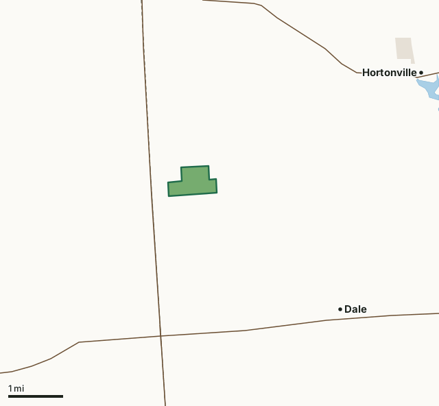
State wildlife areas, forests and other DNR landLand trusts and other open landShaky Lake State Natural AreaCounty lineLakeHighway
| Size | 222 acres |
|---|---|
| County | Outagamie County |
| Deer Management Unit | Outagamie County |
| Public access (DNR) | Open to Hiking, Fishing, Hunting and Trapping |
| DNR property page | Shaky Lake |
| Nearest towns | Dale (3 mi), Hortonville (4 mi) and New London (6 mi) |
What is Shaky Lake State Natural Area like?
Shaky Lake is a marl-bottomed bog lake surrounded by wire-leaved sedge meadow, tamarack swamp, and lacustrine forest. Grass-leaved pondweed, chara, and yellow pond-lily are the dominant submergents. Emergent aquatics include hard and soft-stem bulrushes and arrowheads with scattered clumps of cat-tail. A quaking sedge mat, containing wire-leaved sedges and many plant species characteristic of bog and fen communities, dominates most of the lake basin. A narrow zone of alders and willows forms the transition from open mat to the surrounding forest of lacustrine hardwoods and tamarack. Summer resident wildlife includes green-backed herons, black ducks, mallards, sharp-shinned hawks, and broad-winged hawks. The soils of the area are described as Granby, Shawano, and Emmet, all loamy sands and sandy loams, and shallow peat.
Highway 45 and County T, 1 mile northwest of Hortonville, go south on T for 1 mile, then west on County TT for 2 miles, then south on Ledge Hill Road 0.8 miles, just past a private driveway. Park and walk south 0.2 miles on a small volunteer footpath (a legal right-of-way) to the northeast corner of the SNA, which is marked with SNA boundary signs. The no trespassing signs refer to the lands east and west of the 66-foot wide right-of-way.
In the DNR's words, from its page for the property.
What are the rules on Shaky Lake State Natural Area?
The DNR's property map lists Shaky Lake State Natural Area as "Open to Hiking, Fishing, Hunting and Trapping". Hunting follows Wisconsin's statewide seasons and the rules posted on the property.
How many deer are taken around Shaky Lake State Natural Area?
Shaky Lake State Natural Area lies in Outagamie County. The DNR registered 4,322 deer in Outagamie County in 2025, against 4,318 in 2024.
| DMU | Shaky Lake State Natural Area acres in it | Deer, 2025 | Deer, 2024 | Deer, 2023 |
|---|---|---|---|---|
| Outagamie County | 222 | 4,322 | 4,318 | 3,847 |
Harvest for the whole deer management unit, not the property alone: Wisconsin DNR Deer Metrics (registered harvest by deer management unit).
How do you get to Shaky Lake State Natural Area?
Nearest towns: Dale (3 miles), Hortonville (4 miles), New London (6 miles) and Northport (7 miles). Highways within 5 miles: US 45, WI 96 and WI 15.
What other public land is near Shaky Lake State Natural Area?
DNR properties within 10 miles:
- Lower Wolf River Bottomlands Natural Resource Area: 3,670 acres, 4 miles away
- Rat River Wildlife Area: 4,589 acres, 4.6 miles away
- Mukwa Wildlife Area: 1,338 acres, 5.1 miles away
- Hortonville Bog State Natural Area: 794 acres, 5.4 miles away
- Wolf River Bottoms Wildlife Area: 3,142 acres, 5.5 miles away
Public land within 3 miles of Shaky Lake State Natural Area
Counting Shaky Lake State Natural Area itself, 222 of the 23,139 acres within 3 miles of its boundary are public land open to the public (1%), by USGS PAD-US 4.1 (fee land open to the public).
| Manager | Acres within 3 miles |
|---|---|
| State wildlife areas, forests and other DNR land | 222 |
Questions hunters ask
Where is Shaky Lake State Natural Area?
In Outagamie County, 3 miles from Dale. The DNR's property page has its maps and parking.
Is Shaky Lake State Natural Area open to hunting?
Yes. The DNR's property map lists it as "Open to Hiking, Fishing, Hunting and Trapping". Posted refuges or closed areas, where there are any, are marked on site.
Which deer management unit is Shaky Lake State Natural Area in?
Outagamie County.
How much public land is around Shaky Lake State Natural Area?
222 acres within 3 miles of its boundary, Shaky Lake State Natural Area included, by PAD-US 4.1. The closest other DNR property is Lower Wolf River Bottomlands Natural Resource Area (4 miles).
Get a Wisconsin hunt plan when they open
Hunt plans for Wisconsin are coming. Join the list and you'll hear first. The first 50 hunters in each new state get their plan free.
Until then, the free FilledTag app for iPhone has a map that works in every state, Wisconsin included.
Where these facts come from
- Area description, species, rules and directions: DNR, Shaky Lake State Natural Area; Wisconsin DNR managed lands open to hunting.
- Boundary and acres: the DNR's map layer above. Surrounding public land: USGS PAD-US 4.1 (fee land open to the public).
- Deer harvest: Wisconsin DNR Deer Metrics (registered harvest by deer management unit).
FilledTag is not part of the Wisconsin Department of Natural Resources. Check the DNR's rules and posted signs before you go.