Red Cedar River Savanna State Natural Area: hunting and access
Red Cedar River Savanna State Natural Area is 182 acres of land managed by the Wisconsin DNR in Dunn County, 2 miles from Tainter Lake. Hunters registered 9,118 deer in Dunn County in 2025.
Data updated October 2026. Area facts: the DNR's DNR property data, read 2026-10. Harvest: DNR Deer Metrics.
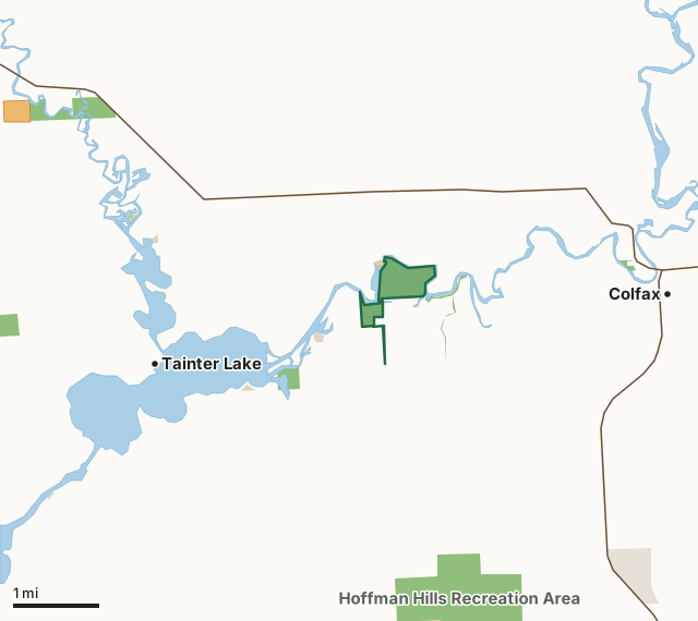
State wildlife areas, forests and other DNR landOther federal landState parksOther county, city and regional landLand trusts and other open landVoluntary Public Access landRed Cedar River Savanna State Natural AreaCounty lineLakeHighway
| Size | 182 acres in 3 pieces |
|---|---|
| County | Dunn County |
| Deer Management Unit | Dunn County |
| Public access (DNR) | Open to Hiking, Fishing, Hunting and Trapping |
| DNR property page | Red Cedar River Savanna |
| Nearest towns | Tainter Lake (2 mi), Colfax (3 mi) and Wheeler (6 mi) |
What is Red Cedar River Savanna State Natural Area like?
Located on sand islands and terraces within the Red Cedar River floodplain, the Red Cedar River Savanna features a unique dry savanna on riverine sand and gravel deposits. A mosaic of natural features is present on this river island including pine-oak savanna, patches of barrens, backwater sloughs, open sand and gravel bars, and floodplain forest. Jack pine and bur oak are scattered throughout the openings and dominate the eastern portion of the island while a canopy of white pine, swamp white oak, and green ash dominate the island's western side. The ground layer is diverse and contains at least 27 savanna indicator plant species including prairie brome, silky wild rye, New Jersey tea, woodland thistle, goat's rue, Canada hawkweed, and fringed puccoon. An abundance of prairie dropseed is also present indicating a lack of intensive past grazing.
Dunn County. T29N-R12W, Sections 11, 12, 13, 14. 190 acres. From the intersection of County BB (Railroad Ave) and Highway 40 in Colfax, go west on County BB for 3 miles, then west for 1 mile on 850th Avenue, then north on 730th Street for 0.5 miles. This will take you onto Dunn County land. Do not take the left fork in the road as this leads to private land. Park and walk west into the SNA. Signs mark the SNA boundary. To access the SNA portion across the river, from Colfax, go west on County BB for 3 miles, then west on 850th Avenue for 0.25 miles to a sand/gravel road to the right with a Dobbs Landing sign. Continue north 0.5 miles, then go left at the fork and continue about 0.35 miles to a canoe landing.
In the DNR's words, from its page for the property.
What are the rules on Red Cedar River Savanna State Natural Area?
The DNR's property map lists Red Cedar River Savanna State Natural Area as "Open to Hiking, Fishing, Hunting and Trapping". Hunting follows Wisconsin's statewide seasons and the rules posted on the property.
How many deer are taken around Red Cedar River Savanna State Natural Area?
Red Cedar River Savanna State Natural Area lies in Dunn County. The DNR registered 9,118 deer in Dunn County in 2025, against 7,819 in 2024.
| DMU | Red Cedar River Savanna State Natural Area acres in it | Deer, 2025 | Deer, 2024 | Deer, 2023 |
|---|---|---|---|---|
| Dunn County | 182 | 9,118 | 7,819 | 6,979 |
Harvest for the whole deer management unit, not the property alone: Wisconsin DNR Deer Metrics (registered harvest by deer management unit).
How do you get to Red Cedar River Savanna State Natural Area?
Nearest towns: Tainter Lake (2 miles), Colfax (3 miles), Wheeler (6 miles) and Menomonie (9 miles). Highways within 5 miles: WI 170, WI 40 and WI 25.
What other public land is near Red Cedar River Savanna State Natural Area?
DNR properties within 10 miles:
- Hoffman Hills Recreation Area: 715 acres, 2.3 miles away
- Otter Creek Oak Barrens State Natural Area: 406 acres, 5.7 miles away
Public land within 3 miles of Red Cedar River Savanna State Natural Area
Counting Red Cedar River Savanna State Natural Area itself, 700 of the 24,772 acres within 3 miles of its boundary are public land open to the public (2.8%), by USGS PAD-US 4.1 (fee land open to the public).
| Manager | Acres within 3 miles |
|---|---|
| State wildlife areas, forests and other DNR land | 670 |
| Other county, city and regional land | 15 |
| Other federal land | 14 |
| State parks | 1 |
Questions hunters ask
Where is Red Cedar River Savanna State Natural Area?
In Dunn County, 2 miles from Tainter Lake. The DNR's property page has its maps and parking.
Is Red Cedar River Savanna State Natural Area open to hunting?
Yes. The DNR's property map lists it as "Open to Hiking, Fishing, Hunting and Trapping". Posted refuges or closed areas, where there are any, are marked on site.
Which deer management unit is Red Cedar River Savanna State Natural Area in?
Dunn County.
How much public land is around Red Cedar River Savanna State Natural Area?
700 acres within 3 miles of its boundary, Red Cedar River Savanna State Natural Area included, by PAD-US 4.1. The closest other DNR property is Hoffman Hills Recreation Area (2.3 miles).
Get a Wisconsin hunt plan when they open
Hunt plans for Wisconsin are coming. Join the list and you'll hear first. The first 50 hunters in each new state get their plan free.
Until then, the free FilledTag app for iPhone has a map that works in every state, Wisconsin included.
Where these facts come from
- Area description, species, rules and directions: DNR, Red Cedar River Savanna State Natural Area; Wisconsin DNR managed lands open to hunting.
- Boundary and acres: the DNR's map layer above. Surrounding public land: USGS PAD-US 4.1 (fee land open to the public).
- Deer harvest: Wisconsin DNR Deer Metrics (registered harvest by deer management unit).
FilledTag is not part of the Wisconsin Department of Natural Resources. Check the DNR's rules and posted signs before you go.