Rush Creek State Natural Area: hunting and access
Rush Creek State Natural Area is 2,943 acres of land managed by the Wisconsin DNR in Crawford County, 2 miles from Ferryville. Hunters registered 5,420 deer in Crawford County in 2025.
Data updated October 2026. Area facts: the DNR's DNR property data, read 2026-10. Harvest: DNR Deer Metrics.
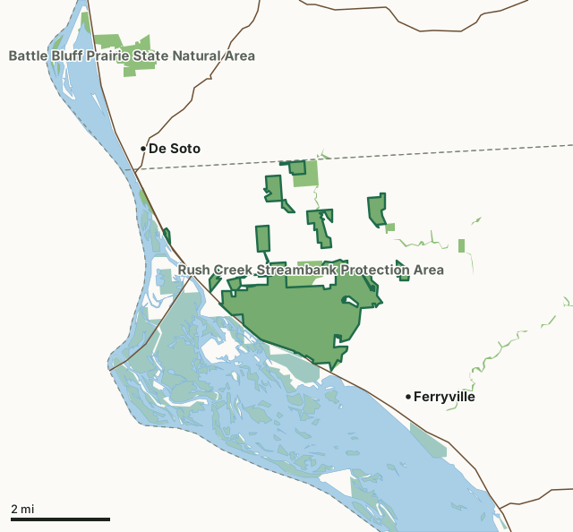
State wildlife areas, forests and other DNR landNational wildlife refuges and waterfowl production areasLand trusts and other open landRush Creek State Natural AreaCounty lineLakeHighway
| Size | 2,943 acres in 11 pieces |
|---|---|
| County | Crawford County |
| Deer Management Unit | Crawford County |
| Public access (DNR) | Open to Hiking, Fishing, Hunting and Trapping |
| DNR property page | Rush Creek |
| Nearest towns | Ferryville (2 mi), De Soto (2 mi) and Lynxville (9 mi) |
What is Rush Creek State Natural Area like?
The outstanding feature of Rush Creek is a two-mile-long series of dry, alkaline prairies situated on the steep southwest-facing limestone-capped bluffs of the Mississippi River. These “goat prairies”, named for their steep, rocky terrain, are part of the most extensive dry prairie remnants left in the state. While most Wisconsin prairies were lost to the plow or development, Rush Creek’s steepness and dry southwestern exposure are largely responsible for its preservation. Characteristic plants include lead plant, little blue-stem, side-oats grama, silky aster, blazing star, wood betony, compass plant, and bird’s-foot violet. The narrow north and east-facing slopes bluff tops are forested with red and white oak and a significant amount of black walnut, hickory, basswood, sugar maple, and aspen.
Crawford County. T10N-R6W, Sections 5, 6, 7. T10N-R7W, Section 1. T11N-R6W, Sections 19, 21, 28-33. T11N-R7W, Sections 11, 25, 36. 3,187 acres. From the intersection of State Highway 35 and County Highway C in Ferryville, go north on Highway 35 for 3.1 miles, then northeast on Rush Creek Road for 0.5 miles to a parking area west of the road. Cross the road and walk east on an access lane to the blufftop. Or, continue north on 35 from its junction with Rush Creek Road 0.8 miles to a parking area. Walk up the slope.
In the DNR's words, from its page for the property.
What are the rules on Rush Creek State Natural Area?
The DNR's property map lists Rush Creek State Natural Area as "Open to Hiking, Fishing, Hunting and Trapping". Hunting follows Wisconsin's statewide seasons and the rules posted on the property.
How many deer are taken around Rush Creek State Natural Area?
Rush Creek State Natural Area lies in Crawford County. The DNR registered 5,420 deer in Crawford County in 2025, against 5,067 in 2024.
| DMU | Rush Creek State Natural Area acres in it | Deer, 2025 | Deer, 2024 | Deer, 2023 |
|---|---|---|---|---|
| Crawford County | 2,943 | 5,420 | 5,067 | 5,067 |
Harvest for the whole deer management unit, not the property alone: Wisconsin DNR Deer Metrics (registered harvest by deer management unit).
How do you get to Rush Creek State Natural Area?
Nearest towns: Ferryville (2 miles), De Soto (2 miles), Lynxville (9 miles) and Mount Sterling (10 miles). Highways within 5 miles: WI 82, WI 35 and WI 171.
What other public land is near Rush Creek State Natural Area?
DNR properties within 10 miles:
- Rush Creek Streambank Protection Area: 375 acres, next to it
- Lower Wisconsin State Riverway: 47,767 acres, next to it
- La Crosse Area Comprehensive Fishery Area: 2,495 acres, 2.2 miles away
- Battle Bluff Prairie State Natural Area: 344 acres, 3 miles away
Public land within 3 miles of Rush Creek State Natural Area
Counting Rush Creek State Natural Area itself, 10,718 of the 52,108 acres within 3 miles of its boundary are public land open to the public (20.6%), by USGS PAD-US 4.1 (fee land open to the public).
| Manager | Acres within 3 miles |
|---|---|
| National wildlife refuges and waterfowl production areas | 7,257 |
| State wildlife areas, forests and other DNR land | 3,455 |
| Land trusts and other open land | 6 |
Questions hunters ask
Where is Rush Creek State Natural Area?
In Crawford County, 2 miles from Ferryville. The DNR's property page has its maps and parking.
Is Rush Creek State Natural Area open to hunting?
Yes. The DNR's property map lists it as "Open to Hiking, Fishing, Hunting and Trapping". Posted refuges or closed areas, where there are any, are marked on site.
Which deer management unit is Rush Creek State Natural Area in?
Crawford County.
How much public land is around Rush Creek State Natural Area?
10,718 acres within 3 miles of its boundary, Rush Creek State Natural Area included, by PAD-US 4.1. The closest other DNR property is Rush Creek Streambank Protection Area (next to it).
Get a Wisconsin hunt plan when they open
Hunt plans for Wisconsin are coming. Join the list and you'll hear first. The first 50 hunters in each new state get their plan free.
Until then, the free FilledTag app for iPhone has a map that works in every state, Wisconsin included.
Where these facts come from
- Area description, species, rules and directions: DNR, Rush Creek State Natural Area; Wisconsin DNR managed lands open to hunting.
- Boundary and acres: the DNR's map layer above. Surrounding public land: USGS PAD-US 4.1 (fee land open to the public).
- Deer harvest: Wisconsin DNR Deer Metrics (registered harvest by deer management unit).
FilledTag is not part of the Wisconsin Department of Natural Resources. Check the DNR's rules and posted signs before you go.