Battle Bluff Prairie State Natural Area: hunting and access
Battle Bluff Prairie State Natural Area is 344 acres of land managed by the Wisconsin DNR in Vernon County, next to De Soto. Hunters registered 9,561 deer in Vernon County in 2025.
Data updated October 2026. Area facts: the DNR's DNR property data, read 2026-10. Harvest: DNR Deer Metrics.
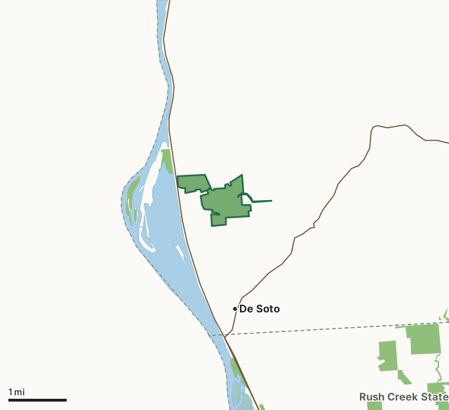
State wildlife areas, forests and other DNR landNational wildlife refuges and waterfowl production areasOther county, city and regional landBattle Bluff Prairie State Natural AreaCounty lineLakeHighway
| Size | 344 acres in 2 pieces |
|---|---|
| County | Vernon County |
| Deer Management Unit | Vernon County |
| Public access (DNR) | Open to Hiking, Fishing, Hunting and Trapping |
| DNR property page | Battle Bluff Prairie |
| Nearest towns | De Soto (next to it), Genoa (8 mi) and Ferryville (8 mi) |
What is Battle Bluff Prairie State Natural Area like?
Vernon County. T11N-R7W, Section 2, 3, 4, 10. 338 acres. Battle Bluff Prairie, the site of one of the Black Hawk War battles contains southern dry forest and a south-facing dry prairie on a steep slope. The diverse prairie flora is interspersed with limestone boulders, sandstone outcrops, and a few stunted trees. More than 80 species of native prairie plants have been identified. Grasses include big and little blue-stem, side-oats grama, hairy grama,.
Canada wild-rye, and needle grass. Forbs include lyre-leaved rock-cress, butterfly milkweed, Illinois tick-trefoil, northern bedstraw, yellow-star grass, wild bergamot, rough blazing-star, prairie phlox, and bird's-foot violet. On the top and at the bottom the prairie gives way to a forest dominated by oaks, birch, and basswood. The wind-eroded sandstone outcrops and limestone boulders contain several unusual plants such as cliff brake and Canada yew. The bluff rises some 480 feet to the top where one has a clear view for many miles to the south across the Mississippi River. The rapid warming of the steep, south-facing slope forms convective thermals that are well-known and used by migrating diurnal raptors. Battle Bluff Prairie is owned by the DNR and was designated a State Natural Area in 1983.
In the DNR's words, from its page for the property.
What are the rules on Battle Bluff Prairie State Natural Area?
The DNR's property map lists Battle Bluff Prairie State Natural Area as "Open to Hiking, Fishing, Hunting and Trapping". Hunting follows Wisconsin's statewide seasons and the rules posted on the property.
How many deer are taken around Battle Bluff Prairie State Natural Area?
Battle Bluff Prairie State Natural Area lies in Vernon County. The DNR registered 9,561 deer in Vernon County in 2025, against 9,000 in 2024.
| DMU | Battle Bluff Prairie State Natural Area acres in it | Deer, 2025 | Deer, 2024 | Deer, 2023 |
|---|---|---|---|---|
| Vernon County | 344 | 9,561 | 9,000 | 8,787 |
Harvest for the whole deer management unit, not the property alone: Wisconsin DNR Deer Metrics (registered harvest by deer management unit).
How do you get to Battle Bluff Prairie State Natural Area?
Nearest towns: De Soto (next to it), Genoa (8 miles), Ferryville (8 miles) and Stoddard (14 miles). Highways within 5 miles: WI 82 and WI 35.
What other public land is near Battle Bluff Prairie State Natural Area?
DNR properties within 10 miles:
- Lower Wisconsin State Riverway: 47,767 acres, 2.2 miles away
- Rush Creek State Natural Area: 2,943 acres, 3 miles away
- Rush Creek Streambank Protection Area: 375 acres, 3.4 miles away
- Romance Prairie State Natural Area: 77 acres, 6.7 miles away
Public land within 3 miles of Battle Bluff Prairie State Natural Area
Counting Battle Bluff Prairie State Natural Area itself, 542 of the 26,299 acres within 3 miles of its boundary are public land open to the public (2.1%), by USGS PAD-US 4.1 (fee land open to the public).
| Manager | Acres within 3 miles |
|---|---|
| State wildlife areas, forests and other DNR land | 494 |
| National wildlife refuges and waterfowl production areas | 46 |
| Other county, city and regional land | 2 |
Questions hunters ask
Where is Battle Bluff Prairie State Natural Area?
In Vernon County, next to De Soto. The DNR's property page has its maps and parking.
Is Battle Bluff Prairie State Natural Area open to hunting?
Yes. The DNR's property map lists it as "Open to Hiking, Fishing, Hunting and Trapping". Posted refuges or closed areas, where there are any, are marked on site.
Which deer management unit is Battle Bluff Prairie State Natural Area in?
Vernon County.
How much public land is around Battle Bluff Prairie State Natural Area?
542 acres within 3 miles of its boundary, Battle Bluff Prairie State Natural Area included, by PAD-US 4.1. The closest other DNR property is Lower Wisconsin State Riverway (2.2 miles).
Get a Wisconsin hunt plan when they open
Hunt plans for Wisconsin are coming. Join the list and you'll hear first. The first 50 hunters in each new state get their plan free.
Until then, the free FilledTag app for iPhone has a map that works in every state, Wisconsin included.
Where these facts come from
- Area description, species, rules and directions: DNR, Battle Bluff Prairie State Natural Area; Wisconsin DNR managed lands open to hunting.
- Boundary and acres: the DNR's map layer above. Surrounding public land: USGS PAD-US 4.1 (fee land open to the public).
- Deer harvest: Wisconsin DNR Deer Metrics (registered harvest by deer management unit).
FilledTag is not part of the Wisconsin Department of Natural Resources. Check the DNR's rules and posted signs before you go.