Spur Lake State Natural Area: hunting and access
Spur Lake State Natural Area is 435 acres of land managed by the Wisconsin DNR in Oneida County, 5 miles from Three Lakes. Hunters registered 1,155 deer in DMU 120 in 2025.
Data updated October 2026. Area facts: the DNR's DNR property data, read 2026-10. Harvest: DNR Deer Metrics.
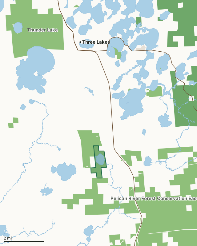
State wildlife areas, forests and other DNR landNational forestLand trusts and other open landSpur Lake State Natural AreaCounty lineLakeHighway
| Size | 435 acres |
|---|---|
| County | Oneida County |
| Deer Management Unit | DMU 120 |
| Public access (DNR) | Open to Hiking, Fishing, Hunting and Trapping |
| DNR property page | Spur Lake |
| Nearest towns | Three Lakes (5 mi), Rhinelander (14 mi) and Argonne (14 mi) |
What is Spur Lake State Natural Area like?
Spur Lake is a 113-acre muck-bottomed soft-water drainage lake that supports dense beds of emergent, submergent, and floating-leaved aquatic plants. Wild rice is the dominant emergent species. Other plants include white water-lily, bullhead water-lily, large-leaved pondweed, ribbon-leaf pondweed, common pondweed, common bladderwort, pickerel weed, and soft-stem bulrush. Wetlands including open bog, alder thicket, and black spruce-tamarack-white cedar swamp surround the majority of the lake's shoreline. Along the northeast corner is a small stand of old-growth hemlock hardwoods and a floating bog mat. The outlet stream, Twin Lakes Creek, flows southward, joining the Pelican River, which in turn flows to the Wisconsin River. The lake and surrounding wetlands provide a habitat for black ducks, ring-necked ducks, osprey, and common loons. Use by migratory waterfowl is heavy.
Oneida County. T37N-R11E, Sections 6, 7. T38N-R11E, Section 31. 426 acres. From the intersection of Highways 32 and 45 on the east side of Three Lakes, go south on 45 for 5 miles, then west and south on Stella Lake Road for 1 mile to Spur Lake.
In the DNR's words, from its page for the property.
What are the rules on Spur Lake State Natural Area?
The DNR's property map lists Spur Lake State Natural Area as "Open to Hiking, Fishing, Hunting and Trapping". Hunting follows Wisconsin's statewide seasons and the rules posted on the property.
How many deer are taken around Spur Lake State Natural Area?
Spur Lake State Natural Area lies in DMU 120. The DNR registered 1,155 deer in DMU 120 in 2025.
| DMU | Spur Lake State Natural Area acres in it | Deer, 2025 |
|---|---|---|
| DMU 120 | 435 | 1,155 |
Harvest for the whole deer management unit, not the property alone: Wisconsin DNR Deer Metrics (registered harvest by deer management unit).
How do you get to Spur Lake State Natural Area?
Nearest towns: Three Lakes (5 miles), Rhinelander (14 miles), Argonne (14 miles) and Eagle River (14 miles). Highways within 5 miles: US 45 and WI 32.
What other public land is near Spur Lake State Natural Area?
DNR properties within 10 miles:
- Pelican River Forest Conservation Easement: 67,444 acres, next to it
- Town of Three Lakes State Habitat Area: 210 acres, 3.4 miles away
- Sugar Camp Hemlocks State Natural Area: 80 acres, 3.8 miles away
- Thunder Lake Wildlife Area: 3,253 acres, 4.9 miles away
Public land within 3 miles of Spur Lake State Natural Area
Counting Spur Lake State Natural Area itself, 4,267 of the 26,306 acres within 3 miles of its boundary are public land open to the public (16.2%), by USGS PAD-US 4.1 (fee land open to the public).
| Manager | Acres within 3 miles |
|---|---|
| State wildlife areas, forests and other DNR land | 4,267 |
Questions hunters ask
Where is Spur Lake State Natural Area?
In Oneida County, 5 miles from Three Lakes. The DNR's property page has its maps and parking.
Is Spur Lake State Natural Area open to hunting?
Yes. The DNR's property map lists it as "Open to Hiking, Fishing, Hunting and Trapping". Posted refuges or closed areas, where there are any, are marked on site.
Which deer management unit is Spur Lake State Natural Area in?
DMU 120.
How much public land is around Spur Lake State Natural Area?
4,267 acres within 3 miles of its boundary, Spur Lake State Natural Area included, by PAD-US 4.1. The closest other DNR property is Pelican River Forest Conservation Easement (next to it).
Get a Wisconsin hunt plan when they open
Hunt plans for Wisconsin are coming. Join the list and you'll hear first. The first 50 hunters in each new state get their plan free.
Until then, the free FilledTag app for iPhone has a map that works in every state, Wisconsin included.
Where these facts come from
- Area description, species, rules and directions: DNR, Spur Lake State Natural Area; Wisconsin DNR managed lands open to hunting.
- Boundary and acres: the DNR's map layer above. Surrounding public land: USGS PAD-US 4.1 (fee land open to the public).
- Deer harvest: Wisconsin DNR Deer Metrics (registered harvest by deer management unit).
FilledTag is not part of the Wisconsin Department of Natural Resources. Check the DNR's rules and posted signs before you go.