Squirrel River Pines State Natural Area: hunting and access
Squirrel River Pines State Natural Area is 1,369 acres of land managed by the Wisconsin DNR in Oneida County, 6 miles from Minocqua. Hunters registered 1,218 deer in DMU 116 in 2025.
Data updated October 2026. Area facts: the DNR's DNR property data, read 2026-10. Harvest: DNR Deer Metrics.
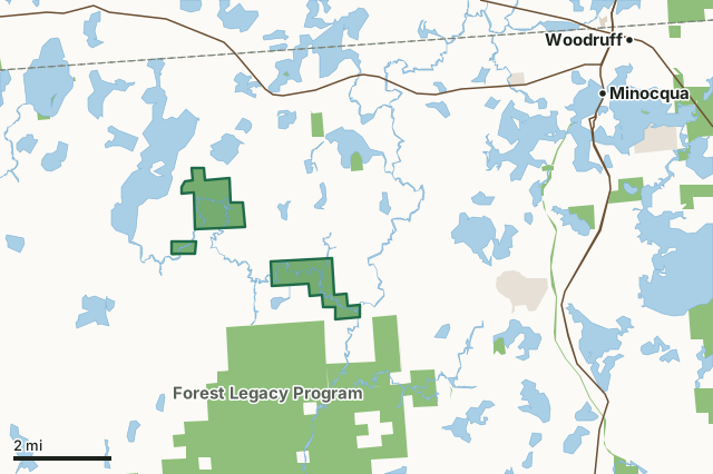
State wildlife areas, forests and other DNR landOther county, city and regional landLand trusts and other open landSquirrel River Pines State Natural AreaCounty lineLakeHighway
| Size | 1,369 acres in 3 pieces |
|---|---|
| County | Oneida County |
| Deer Management Unit | DMU 116 |
| Public access (DNR) | Open to Hiking, Fishing, Hunting and Trapping |
| DNR property page | Squirrel River Pines |
| Nearest towns | Minocqua (6 mi), Lac du Flambeau (7 mi) and Woodruff (8 mi) |
What is Squirrel River Pines State Natural Area like?
Squirrel River Pines features a fine example of a northern dry-mesic forest situated on a narrow, sandy peninsula running northeasterly towards the Squirrel River. The forest is dominated by a stand of old, large red pines in the 16" to 24" diameter size class, with a few trees up to 30" in diameter. White pine makes up roughly 10% of the canopy but constitutes most of the reproduction. Charring on some of the oldest stumps and snags indicates a fire history and probable origin of this stand. The shrub layer is moderately dense, with beaked hazel and Amelanchier species dominant. The herbaceous and low shrub layer is primarily composed of wintergreen, early low blueberry, velvet-leaf blueberry, and Canada mayflower. Other species include pipsissewa, three-leaved goldthread, round-lobed hepatica, twinflower, and one-sided shinleaf.
Oneida County. T39N-R5E, Sections 20, 21, 26, 27, 29, 34, 35, 36. 1,363 acres. To reach the largest stand of pines in the northern unit: from the junction of U.S. Highway 51 and State Highway 70 in Woodruff, go west on Highway 70 about 6.9 miles to Squirrel Lake Road, then south 4.5 miles to Scotchman Lake Road, then east 1.3 miles. The River Run cross-country ski trail operated by Minocqua Winter Park intersects Scotchman Lake Road at this point. Park along the road and walk or ski north (not east) along the trail 0.8 miles to the southern boundary of the natural area. Proceed north another 0.25 miles to reach the pines. The southern unit is best accessed by water via the Squirrel River. Note: Dogs are not allowed allowed on the groomed x-country ski trails.
In the DNR's words, from its page for the property.
What are the rules on Squirrel River Pines State Natural Area?
The DNR's property map lists Squirrel River Pines State Natural Area as "Open to Hiking, Fishing, Hunting and Trapping". Hunting follows Wisconsin's statewide seasons and the rules posted on the property.
How many deer are taken around Squirrel River Pines State Natural Area?
Squirrel River Pines State Natural Area lies in DMU 116. The DNR registered 1,218 deer in DMU 116 in 2025.
| DMU | Squirrel River Pines State Natural Area acres in it | Deer, 2025 |
|---|---|---|
| DMU 116 | 1,369 | 1,218 |
Harvest for the whole deer management unit, not the property alone: Wisconsin DNR Deer Metrics (registered harvest by deer management unit).
How do you get to Squirrel River Pines State Natural Area?
Nearest towns: Minocqua (6 miles), Lac du Flambeau (7 miles), Woodruff (8 miles) and Lake Tomahawk (11 miles). Highways within 5 miles: WI 70 and US 51.
What other public land is near Squirrel River Pines State Natural Area?
DNR properties within 10 miles:
- Forest Legacy Program: 33,075 acres, next to it
- Willow Flowage Scenic Waters Area: 27,366 acres, 0.9 miles away
- Upper Tomahawk River Pines State Natural Area: 365 acres, 0.9 miles away
- Mercer Lake Springs Fishery Area: 78 acres, 1.9 miles away
Public land within 3 miles of Squirrel River Pines State Natural Area
Counting Squirrel River Pines State Natural Area itself, 7,525 of the 42,008 acres within 3 miles of its boundary are public land open to the public (17.9%), by USGS PAD-US 4.1 (fee land open to the public).
| Manager | Acres within 3 miles |
|---|---|
| State wildlife areas, forests and other DNR land | 7,460 |
| Land trusts and other open land | 65 |
Questions hunters ask
Where is Squirrel River Pines State Natural Area?
In Oneida County, 6 miles from Minocqua. The DNR's property page has its maps and parking.
Is Squirrel River Pines State Natural Area open to hunting?
Yes. The DNR's property map lists it as "Open to Hiking, Fishing, Hunting and Trapping". Posted refuges or closed areas, where there are any, are marked on site.
Which deer management unit is Squirrel River Pines State Natural Area in?
DMU 116.
How much public land is around Squirrel River Pines State Natural Area?
7,525 acres within 3 miles of its boundary, Squirrel River Pines State Natural Area included, by PAD-US 4.1. The closest other DNR property is Forest Legacy Program (next to it).
Get a Wisconsin hunt plan when they open
Hunt plans for Wisconsin are coming. Join the list and you'll hear first. The first 50 hunters in each new state get their plan free.
Until then, the free FilledTag app for iPhone has a map that works in every state, Wisconsin included.
Where these facts come from
- Area description, species, rules and directions: DNR, Squirrel River Pines State Natural Area; Wisconsin DNR managed lands open to hunting.
- Boundary and acres: the DNR's map layer above. Surrounding public land: USGS PAD-US 4.1 (fee land open to the public).
- Deer harvest: Wisconsin DNR Deer Metrics (registered harvest by deer management unit).
FilledTag is not part of the Wisconsin Department of Natural Resources. Check the DNR's rules and posted signs before you go.