Upper Tomahawk River Pines State Natural Area: hunting and access
Upper Tomahawk River Pines State Natural Area is 365 acres of land managed by the Wisconsin DNR in Oneida County, 7 miles from Minocqua. Hunters registered 1,218 deer in DMU 116 in 2025.
Data updated October 2026. Area facts: the DNR's DNR property data, read 2026-10. Harvest: DNR Deer Metrics.
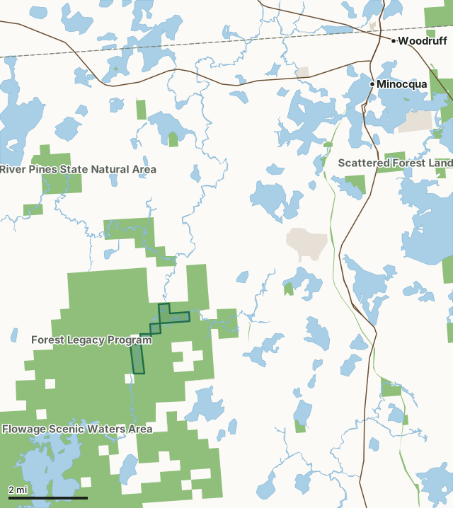
State wildlife areas, forests and other DNR landOther county, city and regional landLand trusts and other open landUpper Tomahawk River Pines State Natural AreaCounty lineLakeHighway
| Size | 365 acres in 4 pieces |
|---|---|
| County | Oneida County |
| Deer Management Unit | DMU 116 |
| Public access (DNR) | Open to Hiking, Fishing, Hunting and Trapping |
| DNR property page | Upper Tomahawk River Pines |
| Nearest towns | Minocqua (7 mi), Woodruff (9 mi) and Lake Tomahawk (11 mi) |
What is Upper Tomahawk River Pines State Natural Area like?
Upper Tomahawk River Pines features several undisturbed stands of large red pine located along a wild and undeveloped reach of the Tomahawk River. The even-aged pines originated following wildfire and are gradually succeeding to white pines, which dominate the understory. The pines are growing on elevated islands separated from the forested uplands by vast wetlands of alder shrub swamp and swamp conifers. These isolated red pine islands provide nesting sites for bald eagles and harbor a characteristic ground layer with bracken fern, wintergreen, and barren strawberry. Alder thickets cover most of the wetlands on both sides of the Tomahawk River with a few areas of tamarack and black spruce. The meandering Tomahawk River is a slow, warm, soft water stream containing a diverse snail fauna in the muck bottom but with relatively few aquatic plants.
The natural area is best accessed by canoe or kayak via the Tomahawk River. Highway 51 and Oneida Street in Hazelhurst, go west on Oneida Street for 0.3 miles, then west on Lower Kaubashine Road for 4.2 miles, then west on Camp Nine Road for 0.8 miles to the Tomahawk River. Paddle 6 miles downstream through the natural area and take out at Cedar Falls Road.
In the DNR's words, from its page for the property.
What are the rules on Upper Tomahawk River Pines State Natural Area?
The DNR's property map lists Upper Tomahawk River Pines State Natural Area as "Open to Hiking, Fishing, Hunting and Trapping". Hunting follows Wisconsin's statewide seasons and the rules posted on the property.
How many deer are taken around Upper Tomahawk River Pines State Natural Area?
Upper Tomahawk River Pines State Natural Area lies in DMU 116. The DNR registered 1,218 deer in DMU 116 in 2025.
| DMU | Upper Tomahawk River Pines State Natural Area acres in it | Deer, 2025 |
|---|---|---|
| DMU 116 | 365 | 1,218 |
Harvest for the whole deer management unit, not the property alone: Wisconsin DNR Deer Metrics (registered harvest by deer management unit).
How do you get to Upper Tomahawk River Pines State Natural Area?
Nearest towns: Minocqua (7 miles), Woodruff (9 miles), Lake Tomahawk (11 miles) and Lac du Flambeau (11 miles). Highways within 5 miles: US 51.
What other public land is near Upper Tomahawk River Pines State Natural Area?
DNR properties within 10 miles:
- Forest Legacy Program: 33,075 acres, next to it
- Willow Flowage Scenic Waters Area: 27,366 acres, next to it
- Squirrel River Pines State Natural Area: 1,369 acres, 0.9 miles away
- Bearskin State Trail: 638 acres, 3.7 miles away
Public land within 3 miles of Upper Tomahawk River Pines State Natural Area
Counting Upper Tomahawk River Pines State Natural Area itself, 12,877 of the 28,593 acres within 3 miles of its boundary are public land open to the public (45%), by USGS PAD-US 4.1 (fee land open to the public).
| Manager | Acres within 3 miles |
|---|---|
| State wildlife areas, forests and other DNR land | 12,825 |
| Land trusts and other open land | 52 |
Questions hunters ask
Where is Upper Tomahawk River Pines State Natural Area?
In Oneida County, 7 miles from Minocqua. The DNR's property page has its maps and parking.
Is Upper Tomahawk River Pines State Natural Area open to hunting?
Yes. The DNR's property map lists it as "Open to Hiking, Fishing, Hunting and Trapping". Posted refuges or closed areas, where there are any, are marked on site.
Which deer management unit is Upper Tomahawk River Pines State Natural Area in?
DMU 116.
How much public land is around Upper Tomahawk River Pines State Natural Area?
12,877 acres within 3 miles of its boundary, Upper Tomahawk River Pines State Natural Area included, by PAD-US 4.1. The closest other DNR property is Forest Legacy Program (next to it).
Get a Wisconsin hunt plan when they open
Hunt plans for Wisconsin are coming. Join the list and you'll hear first. The first 50 hunters in each new state get their plan free.
Until then, the free FilledTag app for iPhone has a map that works in every state, Wisconsin included.
Where these facts come from
- Area description, species, rules and directions: DNR, Upper Tomahawk River Pines State Natural Area; Wisconsin DNR managed lands open to hunting.
- Boundary and acres: the DNR's map layer above. Surrounding public land: USGS PAD-US 4.1 (fee land open to the public).
- Deer harvest: Wisconsin DNR Deer Metrics (registered harvest by deer management unit).
FilledTag is not part of the Wisconsin Department of Natural Resources. Check the DNR's rules and posted signs before you go.