Washington Creek Wildlife Area: hunting and access
Washington Creek Wildlife Area is 517 acres of land managed by the Wisconsin DNR in Rusk County, 8 miles from Bruce. The DNR's page for it names deer, wild turkey, ducks and geese, ruffed grouse, bear and small game among the game here. Hunters registered 3,544 deer in DMU 110 in 2025.
Data updated October 2026. Area facts: the DNR's DNR property data, read 2026-10. Harvest: DNR Deer Metrics.
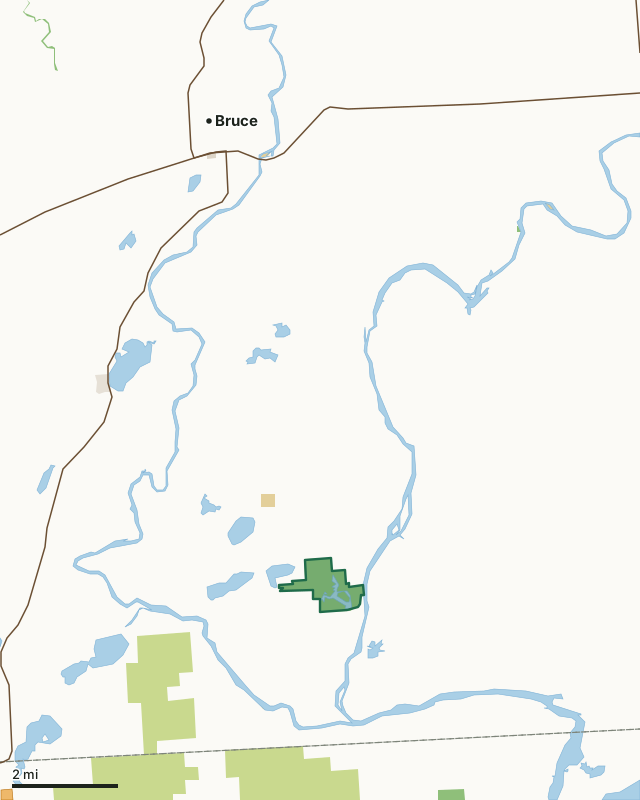
State wildlife areas, forests and other DNR landCounty forestOther federal landOther county, city and regional landLand trusts and other open landVoluntary Public Access landWashington Creek Wildlife AreaCounty lineLakeHighway
| Size | 517 acres |
|---|---|
| County | Rusk County |
| Deer Management Unit | DMU 110 |
| DNR lists for hunting | deer, wild turkey, ducks and geese, ruffed grouse, bear and small game |
| Public access (DNR) | Open to Hiking, Fishing, Hunting and Trapping |
| DNR property page | Washington Creek Wildlife Area |
| Nearest towns | Bruce (8 mi), Holcombe (9 mi) and Weyerhaeuser (10 mi) |
What is Washington Creek Wildlife Area like?
Washington Creek Wildlife Area is a 515-acre property, including approximately 230 acres of flowage and associated wetland, located in south-central Rusk County, approximately 9 miles south of Bruce. The wildlife area was established in 1955 primarily as a waterfowl production area. To provide habitat for waterfowl, the original Washington Creek flowage dam was constructed in 1957 and replaced in 2011. The flowage is actively managed to benefit waterfowl, shorebirds, amphibians, invertebrates, and many other species. A gravel boat launch on the east side of the wildlife area provides access to the Flambeau River. Established in 1955, the area was developed for and is managed as a waterfowl production area.
Habitat consists of a shallow impoundment with an associated matrix of cattail, sedge and floating bog. Smartweed and beggar-ticks in the flowage provide an abundance of food for waterfowl. Wild rice establishment in the flowage may be considered in the future as an additional forage and cultural resource for wildlife and humans alike. Pin oak, uncommon in the area, exists adjacent to the flowage in the upland shrub cover type. Forested areas surrounding the flowage are comprised primarily of aspen, red oak and black spruce swampland. Two openings are maintained in the open upland and aspen stands to provide further diversity to the property. An osprey platform can be seen on the east side of the flowage. The nearby Flambeau River hosts muskellunge, panfish, smallmouth bass, walleye and sturgeon.
In the DNR's words, from its page for the property.
What can you hunt on Washington Creek Wildlife Area?
The DNR's page for Washington Creek Wildlife Area names deer, wild turkey, ducks and geese, ruffed grouse, bear and small game. Each follows Wisconsin's statewide season and, for deer, the tags and rules of the deer management unit.
What are the rules on Washington Creek Wildlife Area?
The DNR's property map lists Washington Creek Wildlife Area as "Open to Hiking, Fishing, Hunting and Trapping". Hunting follows Wisconsin's statewide seasons and the rules posted on the property.
Activities the DNR lists for Washington Creek Wildlife Area: Birding, Canoeing, Cross-country skiing (no designated trail), Hiking (no designated trail), Hunting (noted for waterfowl, ruffed grouse, turkey, deer, bear and small game), Kayaking, Snowmobiling (marked trail), Trapping, Wild edibles/gathering and Wildlife viewing.
How many deer are taken around Washington Creek Wildlife Area?
Washington Creek Wildlife Area lies in DMU 110. The DNR registered 3,544 deer in DMU 110 in 2025.
| DMU | Washington Creek Wildlife Area acres in it | Deer, 2025 |
|---|---|---|
| DMU 110 | 517 | 3,544 |
Harvest for the whole deer management unit, not the property alone: Wisconsin DNR Deer Metrics (registered harvest by deer management unit).
How do you get to Washington Creek Wildlife Area?
Nearest towns: Bruce (8 miles), Holcombe (9 miles), Weyerhaeuser (10 miles) and Conrath (10 miles). Highways within 5 miles: WI 40.
What other public land is near Washington Creek Wildlife Area?
DNR properties within 10 miles:
- Plagge Woods State Natural Area: 81 acres, 3.8 miles away
- Potato Creek Wildlife Area: 942 acres, 5.7 miles away
- Island Lake Wildlife Area: 39 acres, 6 miles away
- Clear Lake State Public Access: 30 acres, 8.1 miles away
- Firth Lake State Ice Age Trail Area: 729 acres, 8.5 miles away
Public land within 3 miles of Washington Creek Wildlife Area
Counting Washington Creek Wildlife Area itself, 1,590 of the 26,620 acres within 3 miles of its boundary are public land open to the public (6%), by USGS PAD-US 4.1 (fee land open to the public).
| Manager | Acres within 3 miles |
|---|---|
| County forest | 990 |
| State wildlife areas, forests and other DNR land | 535 |
| Other federal land | 65 |
Questions hunters ask
Where is Washington Creek Wildlife Area?
In Rusk County, 8 miles from Bruce. The DNR's property page has its maps and parking.
Is Washington Creek Wildlife Area open to hunting?
Yes. The DNR's property map lists it as "Open to Hiking, Fishing, Hunting and Trapping". Posted refuges or closed areas, where there are any, are marked on site.
Which deer management unit is Washington Creek Wildlife Area in?
DMU 110.
How much public land is around Washington Creek Wildlife Area?
1,590 acres within 3 miles of its boundary, Washington Creek Wildlife Area included, by PAD-US 4.1. The closest other DNR property is Plagge Woods State Natural Area (3.8 miles).
Get a Wisconsin hunt plan when they open
Hunt plans for Wisconsin are coming. Join the list and you'll hear first. The first 50 hunters in each new state get their plan free.
Until then, the free FilledTag app for iPhone has a map that works in every state, Wisconsin included.
Where these facts come from
- Area description, species, rules and directions: DNR, Washington Creek Wildlife Area; Wisconsin DNR managed lands open to hunting.
- Boundary and acres: the DNR's map layer above. Surrounding public land: USGS PAD-US 4.1 (fee land open to the public).
- Deer harvest: Wisconsin DNR Deer Metrics (registered harvest by deer management unit).
FilledTag is not part of the Wisconsin Department of Natural Resources. Check the DNR's rules and posted signs before you go.