Potato Creek Wildlife Area: hunting and access
Potato Creek Wildlife Area is 942 acres of land managed by the Wisconsin DNR in Rusk County, 5 miles from Weyerhaeuser. The DNR's page for it names deer, wild turkey, ducks and geese, bear and small game among the game here. Hunters registered 3,544 deer in DMU 110 in 2025.
Data updated October 2026. Area facts: the DNR's DNR property data, read 2026-10. Harvest: DNR Deer Metrics.
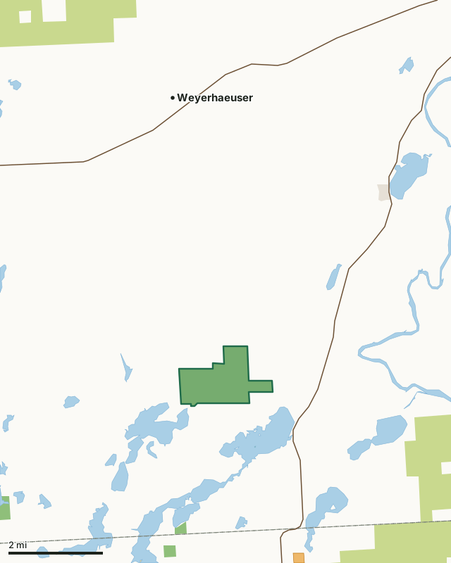
State wildlife areas, forests and other DNR landCounty forestOther federal landLand trusts and other open landVoluntary Public Access landPotato Creek Wildlife AreaCounty lineLakeHighway
| Size | 942 acres |
|---|---|
| County | Rusk County |
| Deer Management Unit | DMU 110 |
| DNR lists for hunting | deer, wild turkey, ducks and geese, bear and small game |
| Public access (DNR) | Open to Hiking, Fishing, Hunting and Trapping |
| DNR property page | Potato Creek Wildlife Area |
| Nearest towns | Weyerhaeuser (5 mi), Bruce (10 mi) and Chetek (11 mi) |
What is Potato Creek Wildlife Area like?
Potato Creek Wildlife Area is a 1,000-acre property in the southwest corner of Rusk County at the outlet of Potato Lake. Located along a road section of the Ice Age Trail (Dzimiela Road). Access points exist on the north end at Kent Road, from the east at Dzimiela Road and south via Rose's Resort Road (public boat landing) at the lake outlet. The wildlife area is bisected by a shallow, warm water creek, which is flanked by wetlands of cattail, sedges, alder and floating bog. The adjacent uplands contain substantial areas of mixed forest and grassland interspersed with scattered ponds to the south and east and upland hardwood forest to the north and west. A small, but high-quality stand of white cedar occurs on the northeast corner of the property. Vegetation consists of approximately 300 acres of wetlands, 400 acres of forested upland and 300 acres of grassland.
This diverse landscape offers a variety of recreational opportunities, including birding, wildlife viewing, hiking, wild edibles gathering, canoeing, hunting and trapping. Established in the early 1950s, the property was developed as a waterfowl production and hunting area. Extensive acreage was inundated with the construction of a low-level dam, but after eight years of washouts and marsh deterioration, the structure and dike were removed. Wild rice has responded favorably to this action. Several runoff ponds have been constructed and extensive upland grassland habitat is maintained to provide nest cover for waterfowl, grassland birds, and other game and non-game species. The Potato Creek Wildlife Area offers many recreational opportunities:. Note: Pets must be on an 8-foot leash from April 15 to July 31.
In the DNR's words, from its page for the property.
What can you hunt on Potato Creek Wildlife Area?
The DNR's page for Potato Creek Wildlife Area names deer, wild turkey, ducks and geese, bear and small game. Each follows Wisconsin's statewide season and, for deer, the tags and rules of the deer management unit.
What are the rules on Potato Creek Wildlife Area?
The DNR's property map lists Potato Creek Wildlife Area as "Open to Hiking, Fishing, Hunting and Trapping". Hunting follows Wisconsin's statewide seasons and the rules posted on the property.
Activities the DNR lists for Potato Creek Wildlife Area: ATV trail (limited, marked trail), Birding, Cross-country skiing (no designated trail), Canoeing, Fishing (limited potential), Hiking (no designated trail), Hunting (noted for deer, turkey, waterfowl, bear and small game), Kayaking, Snowmobiling trail (marked trail), Trapping, Wild edibles/gathering and Wildlife viewing.
How many deer are taken around Potato Creek Wildlife Area?
Potato Creek Wildlife Area lies in DMU 110. The DNR registered 3,544 deer in DMU 110 in 2025.
| DMU | Potato Creek Wildlife Area acres in it | Deer, 2025 |
|---|---|---|
| DMU 110 | 942 | 3,544 |
Harvest for the whole deer management unit, not the property alone: Wisconsin DNR Deer Metrics (registered harvest by deer management unit).
How do you get to Potato Creek Wildlife Area?
Nearest towns: Weyerhaeuser (5 miles), Bruce (10 miles), Chetek (11 miles) and New Auburn (12 miles). Highways within 5 miles: WI 40 and US 8.
What other public land is near Potato Creek Wildlife Area?
DNR properties within 10 miles:
- Island Lake Wildlife Area: 39 acres, 0.7 miles away
- Clear Lake State Public Access: 30 acres, 2.4 miles away
- Ohmart Wetlands State Natural Area: 718 acres, 3 miles away
- Fish Lake State Habitat Area: 95 acres, 4.1 miles away
- Ten Mile Creek Wildlife Area: 408 acres, 5.2 miles away
- Washington Creek Wildlife Area: 517 acres, 5.7 miles away
Public land within 3 miles of Potato Creek Wildlife Area
Counting Potato Creek Wildlife Area itself, 1,018 of the 29,751 acres within 3 miles of its boundary are public land open to the public (3.4%), by USGS PAD-US 4.1 (fee land open to the public).
| Manager | Acres within 3 miles |
|---|---|
| State wildlife areas, forests and other DNR land | 1,015 |
| Other federal land | 3 |
Questions hunters ask
Where is Potato Creek Wildlife Area?
In Rusk County, 5 miles from Weyerhaeuser. The DNR's property page has its maps and parking.
Is Potato Creek Wildlife Area open to hunting?
Yes. The DNR's property map lists it as "Open to Hiking, Fishing, Hunting and Trapping". Posted refuges or closed areas, where there are any, are marked on site.
Which deer management unit is Potato Creek Wildlife Area in?
DMU 110.
How much public land is around Potato Creek Wildlife Area?
1,018 acres within 3 miles of its boundary, Potato Creek Wildlife Area included, by PAD-US 4.1. The closest other DNR property is Island Lake Wildlife Area (0.7 miles).
Get a Wisconsin hunt plan when they open
Hunt plans for Wisconsin are coming. Join the list and you'll hear first. The first 50 hunters in each new state get their plan free.
Until then, the free FilledTag app for iPhone has a map that works in every state, Wisconsin included.
Where these facts come from
- Area description, species, rules and directions: DNR, Potato Creek Wildlife Area; Wisconsin DNR managed lands open to hunting.
- Boundary and acres: the DNR's map layer above. Surrounding public land: USGS PAD-US 4.1 (fee land open to the public).
- Deer harvest: Wisconsin DNR Deer Metrics (registered harvest by deer management unit).
FilledTag is not part of the Wisconsin Department of Natural Resources. Check the DNR's rules and posted signs before you go.