Ohmart Wetlands State Natural Area: hunting and access
Ohmart Wetlands State Natural Area is 718 acres of land managed by the Wisconsin DNR in Chippewa County, 7 miles from New Auburn. Hunters registered 3,544 deer in DMU 110 in 2025.
Data updated October 2026. Area facts: the DNR's DNR property data, read 2026-10. Harvest: DNR Deer Metrics.
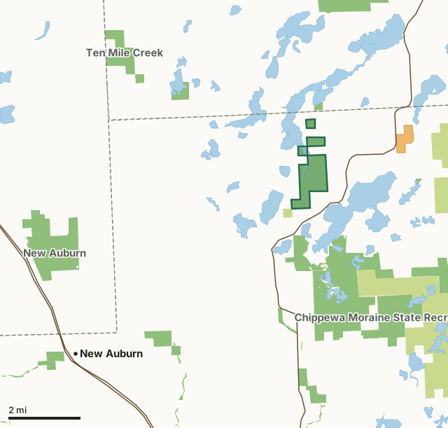
State wildlife areas, forests and other DNR landCounty forestOther federal landState parksVoluntary Public Access landOhmart Wetlands State Natural AreaCounty lineLakeHighway
| Size | 718 acres in 4 pieces |
|---|---|
| County | Chippewa County |
| Deer Management Unit | DMU 110 |
| Public access (DNR) | Open to Hiking, Fishing, Hunting and Trapping |
| DNR property page | Ohmart Wetlands |
| Nearest towns | New Auburn (7 mi), Weyerhaeuser (9 mi) and Bloomer (11 mi) |
What is Ohmart Wetlands State Natural Area like?
Situated within a large glacial lake basin between Long Lake and Chain Lake, Lowell Ohmart Wetlands supports an extensive wetland complex of marsh and forested wetlands with scattered upland islands of northern white cedar. This site lies within the Chippewa Moraine glacial landscape and provides a natural link to other protected county and state lands. Running through the site is Cedar Creek, a low-gradient muck-bottomed stream and inlet to Chain Lake where it provides spawning ground for musky and northern pike. The stream also feeds an extensive emergent marsh that supports beds of wild rice and is heavily used by ducks and other waterfowl. Surrounding the stream is a sedge meadow intermixed with drier hummocks that support black ash, tamarack, spruce, white pine, and white cedar. To the east are uplands of alder, ash, and balsam fir.
Funding was provided by the Knowles-Nelson Stewardship Fund, Chippewa County, the U.S. Fish and Wildlife Service, & CVORA. WWLT transferred the property to the Department of Natural Resources and the site was designated a State Natural Area in 2011. Chippewa County. T32N-9W, Sections 1, 12, 13. 717 acres. The best access is by boat via Chain Lake from a boat launch located on Clear Lake. Winter access is also provided via county land to the southwest and adjacent to Round Lake County Park off 117th Street.
In the DNR's words, from its page for the property.
What are the rules on Ohmart Wetlands State Natural Area?
The DNR's property map lists Ohmart Wetlands State Natural Area as "Open to Hiking, Fishing, Hunting and Trapping". Hunting follows Wisconsin's statewide seasons and the rules posted on the property.
How many deer are taken around Ohmart Wetlands State Natural Area?
Ohmart Wetlands State Natural Area lies in DMU 110. The DNR registered 3,544 deer in DMU 110 in 2025.
| DMU | Ohmart Wetlands State Natural Area acres in it | Deer, 2025 |
|---|---|---|
| DMU 110 | 718 | 3,544 |
Harvest for the whole deer management unit, not the property alone: Wisconsin DNR Deer Metrics (registered harvest by deer management unit).
How do you get to Ohmart Wetlands State Natural Area?
Nearest towns: New Auburn (7 miles), Weyerhaeuser (9 miles), Bloomer (11 miles) and Chetek (11 miles). Highways within 5 miles: WI 40. 1 VPA property within 3 miles.
What other public land is near Ohmart Wetlands State Natural Area?
DNR properties within 10 miles:
- Clear Lake State Public Access: 30 acres, next to it
- Chippewa Moraine State Ice Age Trail Area: 351 acres, 0.7 miles away
- Chippewa Moraine State Recreation Area: 3,555 acres, 1.1 miles away
- Island Lake Wildlife Area: 39 acres, 2.6 miles away
- McCann Creek Fishery Area: 433 acres, 2.8 miles away
- Potato Creek Wildlife Area: 942 acres, 3 miles away
Public land within 3 miles of Ohmart Wetlands State Natural Area
Counting Ohmart Wetlands State Natural Area itself, 2,994 of the 30,770 acres within 3 miles of its boundary are public land open to the public (9.7%), by USGS PAD-US 4.1 (fee land open to the public).
| Manager | Acres within 3 miles |
|---|---|
| State wildlife areas, forests and other DNR land | 2,621 |
| County forest | 344 |
| State parks | 21 |
| Other federal land | 8 |
Questions hunters ask
Where is Ohmart Wetlands State Natural Area?
In Chippewa County, 7 miles from New Auburn. The DNR's property page has its maps and parking.
Is Ohmart Wetlands State Natural Area open to hunting?
Yes. The DNR's property map lists it as "Open to Hiking, Fishing, Hunting and Trapping". Posted refuges or closed areas, where there are any, are marked on site.
Which deer management unit is Ohmart Wetlands State Natural Area in?
DMU 110.
How much public land is around Ohmart Wetlands State Natural Area?
2,994 acres within 3 miles of its boundary, Ohmart Wetlands State Natural Area included, by PAD-US 4.1. The closest other DNR property is Clear Lake State Public Access (next to it).
Get a Wisconsin hunt plan when they open
Hunt plans for Wisconsin are coming. Join the list and you'll hear first. The first 50 hunters in each new state get their plan free.
Until then, the free FilledTag app for iPhone has a map that works in every state, Wisconsin included.
Where these facts come from
- Area description, species, rules and directions: DNR, Ohmart Wetlands State Natural Area; Wisconsin DNR managed lands open to hunting.
- Boundary and acres: the DNR's map layer above. Surrounding public land: USGS PAD-US 4.1 (fee land open to the public).
- Deer harvest: Wisconsin DNR Deer Metrics (registered harvest by deer management unit).
FilledTag is not part of the Wisconsin Department of Natural Resources. Check the DNR's rules and posted signs before you go.