Harold E. Alexander Spring River WMA: deer harvest, 2026-27 seasons and map
Harold E. Alexander Spring River WMA is 13,685 acres of public hunting land in Sharp County, AGFC's WMA zone 290. Hunters checked 114 deer on it in the 2024-25 season, 60 antlered bucks among them (AGFC's deer check records). AGFC's 2026-27 dates for the area: Deer Archery, Aug. 29-31 (one antlered buck only); Sept. 26-Feb. 28.
Data updated October 2026. Seasons and area rules: AGFC's page for the area. Harvest: AGFC's deer check records, 2022-23 to 2024-25.
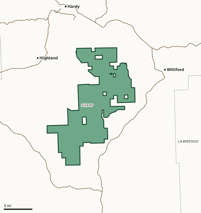
Harold E. Alexander Spring River WMAOther AGFC WMAsLake or riverHighwayCounty line
| Size | 13,685 acres (AGFC) |
|---|---|
| County | Sharp County |
| AGFC WMA zone | 290 |
| Deer zone around it | Zone 3 |
| Area rules | Mobility-Impaired Access, CWD Zone and Valid Hunting or Fishing License or a WMA/Lake Conservation Permit is Required for All Users |
| Deer checked, 2024-25 | 114 (60 antlered bucks, 10 button bucks, 44 does) |
| Phone | 833-856-0879 |
| Nearest towns | Williford (2 mi), Highland (3 mi) and Hardy (3 mi) |
When are the 2026-27 seasons on Harold E. Alexander Spring River WMA?
AGFC sets each WMA's own dates and limits. These are its big game seasons for the area.
2026-27 Closed Seasons
- Alligator
2026-27 Deer
- Deer Archery: Aug. 29-31 (one antlered buck only); Sept. 26-Feb. 28.
- Deer Alternative Firearms (permit required): Oct. 17-21.
- Deer Modern Gun (permit required): Nov. 14-18.
- Deer Modern Gun Youth Hunts: Nov. 7-8 and Jan. 2-3.
- WMA Deer Bag Limit: Three deer, no more than two antlered bucks (no antler restrictions), which may include:
- Two antlered bucks with archery,
- Three antlerless deer with archery,
- One antlered buck and one antlerless deer with alternative firearms permit,
- One altered buck and one antlerless deer with modern gun permit,
- During youth hunts, youths may take two deer, one antlered buck (no antler restrictions) and one antlerless deer.
2026 Bear
- Bear Archery: Sept. 9-Nov. 30
- Bear Alternative Firearms: Oct. 17-21 (deer permit holders only).
- Bear Modern Gun: Nov. 14-18 (deer permit holders only).
- Bear Modern Gun Youth Hunt: Nov. 7-8.
- Bear Notes:
- Seasons close earlier when Bear Zone 1 quota is reached.
2027 Turkey
- Youth Hunt (permit required): April 10-11. One legal turkey.
- Firearms (permit required): April 19-21, April 24-26, May 1-3 and May 7-9. One legal turkey.
Other seasons AGFC lists for the area: crow, quail, rabbit and squirrel. Their dates are on AGFC's page.
Source: AGFC, Harold E. Alexander Spring River WMA, read October 2026. AGFC's page and its regulations are the final word.
How many deer are taken on Harold E. Alexander Spring River WMA?
Hunters checked 114 deer on Harold E. Alexander Spring River WMA in the 2024-25 season. Over the 3 seasons in AGFC's records, the area averaged 95 deer a season.
| Season | Deer checked | Antlered bucks | Button bucks | Does |
|---|---|---|---|---|
| 2024-25 | 114 | 60 | 10 | 44 |
| 2023-24 | 99 | 42 | 4 | 53 |
| 2022-23 | 73 | 30 | 1 | 42 |
Source: AGFC deer check records, 2022-23 to 2024-25, counted by FilledTag from the records AGFC files under this WMA.
What should you know before hunting Harold E. Alexander Spring River WMA?
Location
Harold E. Alexander Spring River WMA is approximately 6 miles south of Hardy, 4 miles north of Sitka, and 5 miles east of Highland in Sharp County. The nearest major cities close to the area are Jonesboro, 70 miles east, Batesville, 49 miles south and Mountain Home, 64 miles west.
Area Notes
Free georeferenced maps are available for this WMA and others at https://apps.agfc.com/maps/. These maps are frequently updated and include features such as parking, types of road and land boundaries.
All caves closed to access.
Camping
The area has 5 primitive camping areas scattered in the area. Theses areas are maintained by the commission and camping is only allowed in these areas. Each camping area has 10 – 15 sites. Camping area 1 is in the north end, camping area 2 is located adjacent to the area headquarters in the middle of the area, camping are 3 is in the southern portion of the area and camping area 4 is in the southern portion of the area.
Description
Harold E. Alexander Spring River WMA is located within the Salem Plateau of the Ozark Highlands and is characterized by gently rolling to hilly topography encompassing narrow ridges and drainages. Spring River and Strawberry River, tributaries off the black River, are two major watersheds within HEASR WMA. The habitat on Harold E. Alexander Spring River WMA is mainly an Oak -Hickory dominated forest with an interspersion of glades. Additionally, 1000 acres of openlands are kept in historic pre-settlement stages by fire and herbicide application. Rock Creek Natural Area consists of 415 acres located in the center of the WMA along Rock Creek, and is managed under a conservation easement with the Arkansas Natural Heritage Commission to help in the preservation of several threatened and endangered plants. Soils on the area can best be described as cherty silt loam with an abundance of exposed limestone, dolomite deposits, and glade rock.
Ownership
13,939-acres are owned by the AGFC; A small, yet interesting part of this WMA is the 415-acre Rock Creek Natural Area, managed by the Arkansas Natural
Heritage Commission. It has one of the highest concentrations of rare plants in Arkansas, most of which are found in a series of seep-fens – permanently
saturated areas – and dolomite glades along Rock Creek and its tributaries.
Age
The area was purchased in 1976.
From AGFC's page for the area.
Which county is Harold E. Alexander Spring River WMA in?
| County | Acres of the area in it | County deer, 2024-25 | Rank of 75 |
|---|---|---|---|
| Sharp County | 13,629 | 2,951 | 28th |
Acres measured by FilledTag on AGFC WMA boundaries and the U.S. Census Bureau 2024 county boundaries. County harvest: AGFC deer check records, 2022-23 to 2024-25.
How do you get to Harold E. Alexander Spring River WMA?
Highways within 5 miles: AR 58, US 63, AR 354 and US 62. Nearest towns: Williford (2 miles), Highland (3 miles), Hardy (3 miles) and Cherokee Village (6 miles).
The closest other WMAs with a page here: Shirey Bay Rainey Brake WMA (15.9 miles), Robert L. Hankins Mud Creek WMA (25.5 miles), Dave Donaldson Black River WMA (28.7 miles) and Devil's Knob Natural Area WMA (32 miles).
Questions hunters ask
When is deer season on Harold E. Alexander Spring River WMA in 2026-27?
AGFC's dates for Harold E. Alexander Spring River WMA: Deer Archery, Aug. 29-31 (one antlered buck only); Sept. 26-Feb. 28. Deer Alternative Firearms (permit required), Oct. 17-21. Deer Modern Gun (permit required), Nov. 14-18. Deer Modern Gun Youth Hunts, Nov. 7-8 and Jan. 2-3.
How many deer can you take on Harold E. Alexander Spring River WMA?
Three deer, no more than two antlered bucks (no antler restrictions), which may include: two antlered bucks with archery, three antlerless deer with archery, one antlered buck and one antlerless deer with alternative firearms permit, one altered buck and one antlerless deer with modern gun permit and during youth hunts, youths may take two deer, one antlered buck (no antler restrictions) and one antlerless deer. (AGFC's 2026-27 rules for the area).
How many deer were killed on Harold E. Alexander Spring River WMA last season?
Hunters checked 114 deer on Harold E. Alexander Spring River WMA in the 2024-25 season: 60 antlered bucks, 10 button bucks and 44 does, by AGFC's deer check records. The 3-season average is 95.
What county is Harold E. Alexander Spring River WMA in?
All of it is in Sharp County, by AGFC's boundary.
Get a Arkansas hunt plan when they open
Hunt plans for Arkansas are coming. Join the list and you'll hear first. The first 50 hunters in each new state get their plan free.
Until then, the free FilledTag app for iPhone has a map that works in every state, Arkansas included.
Where these numbers come from
- Seasons, limits, size and area notes: AGFC's page for each WMA (AGFC Wildlife Management Areas).
- Deer harvest on the area and by county: AGFC deer check records, 2022-23 to 2024-25.
- Boundary: AGFC WMA boundaries. Counties, highways and towns: U.S. Census Bureau 2024 county boundaries; U.S. Census Bureau TIGER/Line 2024 roads; U.S. Census Bureau 2024 Gazetteer. Refuges: U.S. Fish and Wildlife Service refuge boundaries.
FilledTag is not part of the Arkansas Game and Fish Commission. Numbers are copied from AGFC or measured from public maps; nothing on this page is estimated by FilledTag.
Arkansas hunting All Arkansas WMAs Sharp County deer harvest