Piney Creeks WMA: deer harvest, 2026-27 seasons and map
Piney Creeks WMA is 485,419 acres of public hunting land in Pope, Newton, Johnson, Van Buren, Searcy and Conway counties, AGFC's WMA zone 520. Hunters checked 966 deer on it in the 2024-25 season, 598 antlered bucks among them (AGFC's deer check records). AGFC's 2026-27 dates for the area: Deer Archery, Aug. 29-31 (one antlered buck only); Sept. 26-Feb. 28.
Data updated October 2026. Seasons and area rules: AGFC's page for the area. Harvest: AGFC's deer check records, 2022-23 to 2024-25.
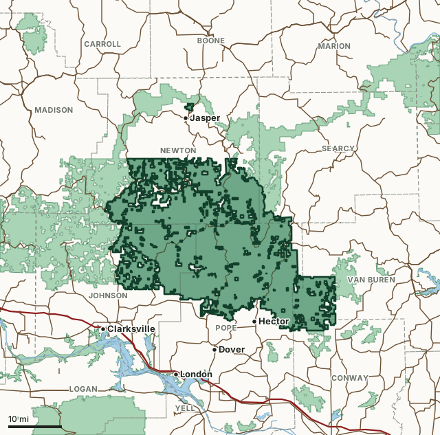
Piney Creeks WMAOther AGFC WMAsNational wildlife refugeLake or riverHighwayCounty line
| Size | 485,419 acres (AGFC) |
|---|---|
| County | Pope County, Newton County, Johnson County, Van Buren County, Searcy County, Conway County |
| AGFC WMA zone | 520 |
| Deer zone around it | Zone 2, Zone 6 |
| Area rules | CWD Zone and Additional USDA Forest Service Regulations |
| Deer checked, 2024-25 | 966 (598 antlered bucks, 61 button bucks, 307 does) |
| Phone | 833-356-0879 |
| Nearest towns | Jasper (next to it), Hector (2 mi) and Dover (6 mi) |
When are the 2026-27 seasons on Piney Creeks WMA?
AGFC sets each WMA's own dates and limits. These are its big game seasons for the area.
2026-27 Closed Seasons
- Alligator
2026-27 Deer
- Deer Archery: Aug. 29-31 (one antlered buck only); Sept. 26-Feb. 28.
- Deer Alternative Firearms: Oct. 17-25.
- Deer Modern Gun: Nov. 14-Dec. 6 and Dec. 26-28.
- Deer Modern Gun Youth Hunts: Nov. 7-8 and Jan. 2-3.
- WMA Deer Bag Limit: Three deer, no more than two antlered bucks (no antler restrictions), which may include:
- Two antlered bucks with archery, alternative firearms or modern gun,
- Two antlerless deer with archery,
- One antlerless deer during alternative firearms season or the first two days of modern gun,
- During youth hunt, youths may take two deer, one antlered buck (no antler restrictions) and one antlerless deer.
2026 Bear
- Bear Archery: Sept. 9-Nov. 30.
- Bear Alternative Firearms: Oct. 17-25.
- Bear Modern Gun: Nov. 14-30.
- Bear Modern Gun Youth Hunt: Nov. 7-8.
- Bear Notes:
- Seasons close earlier when Bear Zone 1 quota is reached.
2027 Turkey
- Youth Hunt: April 10-11. One legal turkey.
- Firearms Hunt: April 19-May 9. One legal turkey.
Other seasons AGFC lists for the area: crow, quail, rabbit and squirrel. Their dates are on AGFC's page.
Source: AGFC, Piney Creeks WMA, read October 2026. AGFC's page and its regulations are the final word.
How many deer are taken on Piney Creeks WMA?
Hunters checked 966 deer on Piney Creeks WMA in the 2024-25 season. Over the 3 seasons in AGFC's records, the area averaged 931 deer a season.
| Season | Deer checked | Antlered bucks | Button bucks | Does |
|---|---|---|---|---|
| 2024-25 | 966 | 598 | 61 | 307 |
| 2023-24 | 875 | 538 | 63 | 274 |
| 2022-23 | 953 | 603 | 40 | 310 |
Source: AGFC deer check records, 2022-23 to 2024-25, counted by FilledTag from the records AGFC files under this WMA.
What should you know before hunting Piney Creeks WMA?
Location
Pope, Johnson and Newton counties. Located 16 miles north of Russellville or 50 miles south of Harrison on Hwy 7 and 15 miles northeast of Clarksville, on Hwy. 123 north.
Area Notes
Free georeferenced maps are available for this WMA and others at https://apps.agfc.com/maps/. These maps are frequently updated and include features such as parking, types of road and land boundaries.
Camping
Longpool Recreation Area is a developed camping, picnic and swimming area that is located on Big Piney Creek, 5 miles west of Hwy. 7 near the southern boundary of the area. Rotary Ann Recreation Area is located 4 miles south of Pelsor on Hwy. 7. and Haw Creek Falls Campground is located 2 miles south of Ft. Douglas on Hwy. 123. The U.S. Forest Service maintains all of the developed recreation areas. Primitive camping is allowed anywhere but on food plots and areas marked closed to camping.
Description
Contains 504,643 acres of rugged Ozark Mountain terrain. The area is predominantly forested in upland hardwoods and mixed shortleaf pine/hardwood forest types. Big Piney Creek and the North Fork of the Illinois Bayou flow generally north to south through the central and eastern part, respectively, and Little Piney Creek more or less traverses the western and southern boundaries of the area.
Ownership
USDA Forest Service (Although there are some privately owned land inholdings, the majority of the land within it is Federally owned.)
Age
Established 1967 through a cooperative agreement between the USDA Forest Service and AGFC.
From AGFC's page for the area.
Which county is Piney Creeks WMA in?
| County | Acres of the area in it | County deer, 2024-25 | Rank of 75 |
|---|---|---|---|
| Pope County | 191,765 | 4,046 | 10th |
| Newton County | 152,723 | 1,319 | 64th |
| Johnson County | 93,005 | 3,160 | 26th |
| Van Buren County | 32,049 | 2,851 | 30th |
| Searcy County | 7,605 | 1,976 | 54th |
| Conway County | 6,889 | 2,547 | 38th |
Acres measured by FilledTag on AGFC WMA boundaries and the U.S. Census Bureau 2024 county boundaries. County harvest: AGFC deer check records, 2022-23 to 2024-25.
How do you get to Piney Creeks WMA?
Highways through the area: AR 16, AR 123, AR 7 and AR 27. Nearest towns: Jasper (next to it), Hector (2 miles), Dover (6 miles) and Lamar (8 miles).
The closest other WMAs with a page here: Bearcat Hollow WMA (next to it), Cherokee WMA (next to it), Scott Henderson Gulf Mountain WMA (next to it) and White Rock WMA (next to it).
Questions hunters ask
When is deer season on Piney Creeks WMA in 2026-27?
AGFC's dates for Piney Creeks WMA: Deer Archery, Aug. 29-31 (one antlered buck only); Sept. 26-Feb. 28. Deer Alternative Firearms, Oct. 17-25. Deer Modern Gun, Nov. 14-Dec. 6 and Dec. 26-28. Deer Modern Gun Youth Hunts, Nov. 7-8 and Jan. 2-3.
How many deer can you take on Piney Creeks WMA?
Three deer, no more than two antlered bucks (no antler restrictions), which may include: two antlered bucks with archery, alternative firearms or modern gun, two antlerless deer with archery, one antlerless deer during alternative firearms season or the first two days of modern gun and during youth hunt, youths may take two deer, one antlered buck (no antler restrictions) and one antlerless deer. (AGFC's 2026-27 rules for the area).
How many deer were killed on Piney Creeks WMA last season?
Hunters checked 966 deer on Piney Creeks WMA in the 2024-25 season: 598 antlered bucks, 61 button bucks and 307 does, by AGFC's deer check records. The 3-season average is 931.
What county is Piney Creeks WMA in?
Pope County (191,765 acres), Newton County (152,723 acres), Johnson County (93,005 acres), Van Buren County (32,049 acres), Searcy County (7,605 acres) and Conway County (6,889 acres), measured on AGFC's boundary.
Get a Arkansas hunt plan when they open
Hunt plans for Arkansas are coming. Join the list and you'll hear first. The first 50 hunters in each new state get their plan free.
Until then, the free FilledTag app for iPhone has a map that works in every state, Arkansas included.
Where these numbers come from
- Seasons, limits, size and area notes: AGFC's page for each WMA (AGFC Wildlife Management Areas).
- Deer harvest on the area and by county: AGFC deer check records, 2022-23 to 2024-25.
- Boundary: AGFC WMA boundaries. Counties, highways and towns: U.S. Census Bureau 2024 county boundaries; U.S. Census Bureau TIGER/Line 2024 roads; U.S. Census Bureau 2024 Gazetteer. Refuges: U.S. Fish and Wildlife Service refuge boundaries.
FilledTag is not part of the Arkansas Game and Fish Commission. Numbers are copied from AGFC or measured from public maps; nothing on this page is estimated by FilledTag.
Arkansas hunting All Arkansas WMAs Pope County deer harvest Newton County deer harvest Johnson County deer harvest