Scott Henderson Gulf Mountain WMA: deer harvest, 2026-27 seasons and map
Scott Henderson Gulf Mountain WMA is 14,923 acres of public hunting land in Van Buren County, AGFC's WMA zone 280. Hunters checked 94 deer on it in the 2024-25 season, 53 antlered bucks among them (AGFC's deer check records). AGFC's 2026-27 dates for the area: Deer Archery, Aug. 29-31 (one antlered buck only); Sept. 26-Feb. 28.
Data updated October 2026. Seasons and area rules: AGFC's page for the area. Harvest: AGFC's deer check records, 2022-23 to 2024-25.
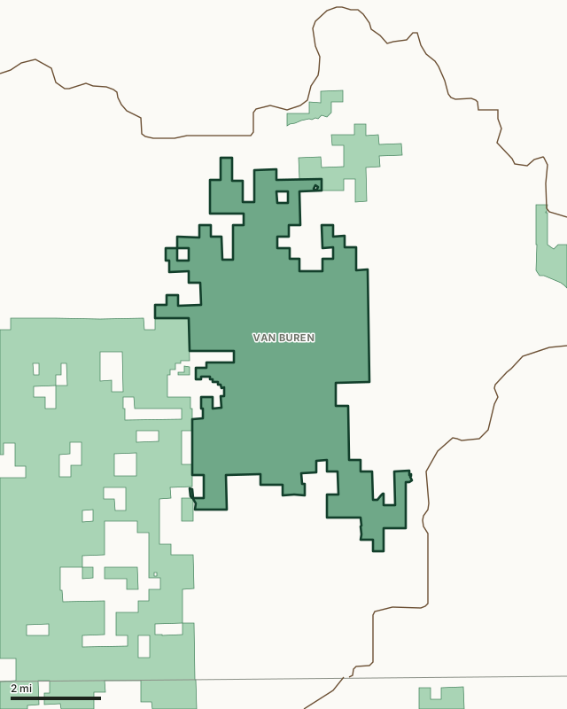
Scott Henderson Gulf Mountain WMAOther AGFC WMAsLake or riverHighwayCounty line
| Size | 14,923 acres (AGFC) |
|---|---|
| County | Van Buren County |
| AGFC WMA zone | 280 |
| Deer zone around it | Zone 6 |
| Area rules | Mobility-Impaired Access, CWD Zone and Valid Hunting or Fishing License or a WMA/Lake Conservation Permit is Required for All Users |
| Deer checked, 2024-25 | 94 (53 antlered bucks, 6 button bucks, 35 does) |
| Phone | 833-356-0879 |
| Nearest towns | Clinton (10 mi), Damascus (15 mi) and Hector (16 mi) |
When are the 2026-27 seasons on Scott Henderson Gulf Mountain WMA?
AGFC sets each WMA's own dates and limits. These are its big game seasons for the area.
2026-27 Closed Seasons
- Alligator
2026-27 Deer
- Deer Archery: Aug. 29-31 (one antlered buck only); Sept. 26-Feb. 28.
- Deer Alternative Firearms (permit required): Oct. 17-21.
- Deer Modern Gun (permit required): Nov. 14-18.
- Deer Modern Gun Youth Hunts: Nov. 7-8 and Jan. 2-3.
- WMA Deer Bag Limit: Three deer, no more than two antlered bucks (no antler restrictions), which may include:
- Two antlered bucks with archery,
- Three antlerless deer with archery,
- One antlered buck and one antlerless deer with alternative firearms permit,
- One antlered buck and one antlerless deer with modern gun permit,
- During the modern gun youth hunts, youths may take two deer, one antlered buck (no antler restrictions) and one antlerless deer.
2026 Bear
- Bear Archery: Sept. 9-Nov. 30.
- Bear Alternative Firearms: Oct. 17-21 (deer permit holders only).
- Bear Modern Gun: Nov. 14-18 (deer permit holders only).
- Bear Youth Modern Gun Hunt: Nov. 7-8
- Bear Notes:
- Seasons close earlier when Bear Zone 1 quota is reached.
2027 Turkey
- Youth Hunt: April 10-11. One legal turkey.
- Firearms Hunt (permit required): April 19-21, April 24-26, May 1-3 and May 7-9. One legal turkey.
Other seasons AGFC lists for the area: crow, quail, rabbit and squirrel. Their dates are on AGFC's page.
Source: AGFC, Scott Henderson Gulf Mountain WMA, read October 2026. AGFC's page and its regulations are the final word.
How many deer are taken on Scott Henderson Gulf Mountain WMA?
Hunters checked 94 deer on Scott Henderson Gulf Mountain WMA in the 2024-25 season. Over the 3 seasons in AGFC's records, the area averaged 84 deer a season.
| Season | Deer checked | Antlered bucks | Button bucks | Does |
|---|---|---|---|---|
| 2024-25 | 94 | 53 | 6 | 35 |
| 2023-24 | 71 | 39 | 3 | 29 |
| 2022-23 | 88 | 34 | 11 | 43 |
Source: AGFC deer check records, 2022-23 to 2024-25, counted by FilledTag from the records AGFC files under this WMA.
What should you know before hunting Scott Henderson Gulf Mountain WMA?
Location
The area is in Van Buren county, about 12 miles southwest of Clinton and 30 miles north of Morrilton. It is bisected on the south by Arkansas Highway 389 and on the north by the south fork of the Little Red River. It is adjoined on the west by the Ozark National Forest, the remaining boundary is adjoined by private land.
Area Notes
Free georeferenced maps are available for this WMA and others at https://apps.agfc.com/maps/. These maps are frequently updated and include features such as parking, types of road and land boundaries.
Camping
Gulf Mountain has six primitive camping areas with 118 camping units.
Description
Gulf Mountain contains 14,000 acres of which approximately 1,000 are in fields in various stages of growth. Composition of timber resources is approximately 65 percent hardwood and 35 percent pine. Hardwood type on the southern exposures is predominantly post oak-blackjack oak. The northern slope hardwoods are predominantly red oaks and white oaks. Topography is gently rolling to mountainous with elevation ranging from 700 feet msl on the south fork Little Red River to 1,500 feet msl on the highest ridge. There are 5.4 miles of streams on the property available via a low-water crossing.
Ownership
The area was purchased by the AGFC in 1970 with the initial purchase totaling 6,400 acres. In 1971, an additional 3,600 acres was purchased and several smaller tracts totaling 2,012 acres have been added since. Approximately 2,000 acres of Green Bay Packaging lands are incorporated into the wildlife management area land base.
Age
The area was founded in 1970 with additional land purchases over the years.
From AGFC's page for the area.
Which county is Scott Henderson Gulf Mountain WMA in?
| County | Acres of the area in it | County deer, 2024-25 | Rank of 75 |
|---|---|---|---|
| Van Buren County | 14,920 | 2,851 | 30th |
Acres measured by FilledTag on AGFC WMA boundaries and the U.S. Census Bureau 2024 county boundaries. County harvest: AGFC deer check records, 2022-23 to 2024-25.
How do you get to Scott Henderson Gulf Mountain WMA?
Highways within 5 miles: AR 16 and AR 95. Nearest towns: Clinton (10 miles), Damascus (15 miles), Hector (16 miles) and Leslie (16 miles).
The closest other WMAs with a page here: Cherokee WMA (next to it), Piney Creeks WMA (next to it), Greers Ferry Lake WMA (9.9 miles) and Rainey WMA (12.2 miles).
Questions hunters ask
When is deer season on Scott Henderson Gulf Mountain WMA in 2026-27?
AGFC's dates for Scott Henderson Gulf Mountain WMA: Deer Archery, Aug. 29-31 (one antlered buck only); Sept. 26-Feb. 28. Deer Alternative Firearms (permit required), Oct. 17-21. Deer Modern Gun (permit required), Nov. 14-18. Deer Modern Gun Youth Hunts, Nov. 7-8 and Jan. 2-3.
How many deer can you take on Scott Henderson Gulf Mountain WMA?
Three deer, no more than two antlered bucks (no antler restrictions), which may include: two antlered bucks with archery, three antlerless deer with archery, one antlered buck and one antlerless deer with alternative firearms permit, one antlered buck and one antlerless deer with modern gun permit and during the modern gun youth hunts, youths may take two deer, one antlered buck (no antler restrictions) and one antlerless deer. (AGFC's 2026-27 rules for the area).
How many deer were killed on Scott Henderson Gulf Mountain WMA last season?
Hunters checked 94 deer on Scott Henderson Gulf Mountain WMA in the 2024-25 season: 53 antlered bucks, 6 button bucks and 35 does, by AGFC's deer check records. The 3-season average is 84.
What county is Scott Henderson Gulf Mountain WMA in?
All of it is in Van Buren County, by AGFC's boundary.
Get a Arkansas hunt plan when they open
Hunt plans for Arkansas are coming. Join the list and you'll hear first. The first 50 hunters in each new state get their plan free.
Until then, the free FilledTag app for iPhone has a map that works in every state, Arkansas included.
Where these numbers come from
- Seasons, limits, size and area notes: AGFC's page for each WMA (AGFC Wildlife Management Areas).
- Deer harvest on the area and by county: AGFC deer check records, 2022-23 to 2024-25.
- Boundary: AGFC WMA boundaries. Counties, highways and towns: U.S. Census Bureau 2024 county boundaries; U.S. Census Bureau TIGER/Line 2024 roads; U.S. Census Bureau 2024 Gazetteer. Refuges: U.S. Fish and Wildlife Service refuge boundaries.
FilledTag is not part of the Arkansas Game and Fish Commission. Numbers are copied from AGFC or measured from public maps; nothing on this page is estimated by FilledTag.
Arkansas hunting All Arkansas WMAs Van Buren County deer harvest