Sylamore WMA: deer harvest, 2026-27 seasons and map
Sylamore WMA is 182,618 acres of public hunting land in Baxter, Stone, Marion and Searcy counties, AGFC's WMA zone 620. Hunters checked 522 deer on it in the 2024-25 season, 271 antlered bucks among them (AGFC's deer check records). AGFC's 2026-27 dates for the area: Deer Archery, Aug. 29-31 (one antlered buck only); Sept. 26-Feb. 28.
Data updated October 2026. Seasons and area rules: AGFC's page for the area. Harvest: AGFC's deer check records, 2022-23 to 2024-25.
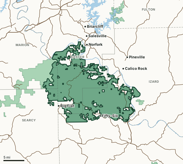
Sylamore WMAOther AGFC WMAsNational wildlife refugeLake or riverHighwayCounty line
| Size | 182,618 acres (AGFC) |
|---|---|
| County | Baxter County, Stone County, Marion County, Searcy County |
| AGFC WMA zone | 620 |
| Deer zone around it | Zone 2 |
| Area rules | CWD ZoneAdditional USDA Forest Service Regulations |
| Deer checked, 2024-25 | 522 (271 antlered bucks, 49 button bucks, 202 does) |
| Phone | 833-356-0879 |
| Nearest towns | Fifty-Six (next to it), Norfork (next to it), Big Flat (next to it) and Salesville (2 mi) |
When are the 2026-27 seasons on Sylamore WMA?
AGFC sets each WMA's own dates and limits. These are its big game seasons for the area.
2026-27 Closed Seasons
- Alligator
2026-27 Deer
- Deer Archery: Aug. 29-31 (one antlered buck only); Sept. 26-Feb. 28.
- Deer Alternative Firearms: Oct. 17-25.
- Deer Modern Gun: Nov. 14-Dec. 6 and Dec. 26-28.
- Deer Modern Gun Youth Hunts: Nov. 7-8 and Jan. 2-3.
- WMA Bag Limit: Three deer, no more than two antlered bucks (no antler restrictions), which may include:
- Two antlered bucks with archery, alternative firearms or modern gun,
- Two antlerless deer with archery,
- One antlerless deer during alternative firearms season or the first two days of modern gun,
- During youth hunt, youths may take two deer, one antlered buck (no antler restriction) and one antlerless deer.
2026 Bear
- Bear Archery: Sept. 9-Nov. 30.
- Bear Alternative Firearms: Oct. 17-25.
- Bear Modern Gun: Nov. 14-30.
- Bear Modern Gun Youth Hunt: Nov. 7-8.
- Bear Notes:
- Seasons close earlier when Bear Zone 1 quota is reached.
2027 Turkey
- Youth Hunt: April 10-11. One legal turkey.
- Firearms Hunt: April 19-21 (permit required), April 22-May 9 (no permit required). One legal turkey.
Other seasons AGFC lists for the area: crow, quail, rabbit and squirrel. Their dates are on AGFC's page.
Source: AGFC, Sylamore WMA, read October 2026. AGFC's page and its regulations are the final word.
How many deer are taken on Sylamore WMA?
Hunters checked 522 deer on Sylamore WMA in the 2024-25 season. Over the 3 seasons in AGFC's records, the area averaged 498 deer a season.
| Season | Deer checked | Antlered bucks | Button bucks | Does |
|---|---|---|---|---|
| 2024-25 | 522 | 271 | 49 | 202 |
| 2023-24 | 525 | 256 | 32 | 237 |
| 2022-23 | 448 | 227 | 27 | 194 |
Source: AGFC deer check records, 2022-23 to 2024-25, counted by FilledTag from the records AGFC files under this WMA.
What should you know before hunting Sylamore WMA?
Location
The WMA lies in four north central Arkansas counties; Searcy, Marion, Stone and Baxter with the majority of the land lying in the latter two. The WMA is approximately 12 miles south of Mountain Home and 6 miles north of Mountain View, with three cities lying on itês border; Calico Rock in the northeast corner, Fifty Six in the south central part, and Big Flat in the southwest corner. The boundary begins at Calico Rock, follow White River down to the small community of Allison (a town north of Mountain View off hwy 14), take hwy 14 from Allison through Fifty Six and through Big Flat until you reach a hwy bridge crossing Big Creek (a small stream approximately 5 miles west of Big Flat0, then follow the stream bed of Big Creek until you reach the Buffalo River, follow Buffalo River to White River, then take White River down to Calico Rock.
Area Notes
Free georeferenced maps are available for this WMA and others at https://apps.agfc.com/maps/. These maps are frequently updated and include features such as parking, types of road and land boundaries.
Dogs, hunting or trapping equipment are not allowed in Blanchard Springs Recreation Area.
The same hunting seasons, method of take, bag limits, shooting hours and permits for hunting which apply to the Sylamore WMA apply to all private lands meeting the criteria of a WMA inholding.
Click here to refer to additional U.S. Forest Service information.
Camping
Already mentioned are the three camping areas on Sylamore that the USFS operates, but camping is allowed anywhere on the WMA. The only restriction is camping is not allowed on the food plots. Other camping sites are found in the surrounding communities, at the Ozark Folk Center, and sites along the rivers and lakes.
Description
Most of the area is oak-hickory stands with some intermingled stands of pure pine. During the 1950s large quantities of white oaks were cut for “stave bolts”, leaving what’s now mature to semi-mature stands of hardwood. The WMA topography is part of the Ozark Mountains, Springfield plateau. The land is mostly narrow, rolling mountains composed of gently (some step near the Buffalo) sloped ridges with good fertile valleys along many streams (both intermittent and permanent). Elevations range from 1,250-1,700 feet as with the rock cliffs being mainly made of limestone. As mentioned earlier there are many streams for fishing and camping with three small lakes; Mirrow Lake (at Blanchard Springs), Gunner Pool Lake (at the recreation area so named), and Hayden Pond (east of the community of Optimus which is south of Calico rock). Most of the open land, not counting food plots and unimproved fields owned by the Forest Service, are improved pastures on the private land.
Ownership
Established March 3, 1908 by the USDA Forest Service from local landowners. Some landowners that did not sell still have inholdings (private land tracts) scattered throughout the WMA. Some landowners still live within the WMA boundaries, more in the northern part of the area. Some of the land along the western boundary (Buffalo River) belongs to the National Park Service.
Age
Established March 3, 1908.
From AGFC's page for the area.
Which county is Sylamore WMA in?
| County | Acres of the area in it | County deer, 2024-25 | Rank of 75 |
|---|---|---|---|
| Baxter County | 64,304 | 2,448 | 43rd |
| Stone County | 59,241 | 2,116 | 50th |
| Marion County | 6,586 | 2,185 | 47th |
| Searcy County | 4,527 | 1,976 | 54th |
Acres measured by FilledTag on AGFC WMA boundaries and the U.S. Census Bureau 2024 county boundaries. County harvest: AGFC deer check records, 2022-23 to 2024-25.
How do you get to Sylamore WMA?
Highways through the area: AR 341, AR 14 and AR 5. Nearest towns: Fifty-Six (next to it), Norfork (next to it), Big Flat (next to it), Salesville (2 miles) and Calico Rock (3 miles).
The closest other WMAs with a page here: Buffalo National River WMA (next to it), Devil's Knob Natural Area WMA (next to it), Loafer's Glory WMA (2.2 miles) and Norfork Lake WMA (9.1 miles).
Questions hunters ask
When is deer season on Sylamore WMA in 2026-27?
AGFC's dates for Sylamore WMA: Deer Archery, Aug. 29-31 (one antlered buck only); Sept. 26-Feb. 28. Deer Alternative Firearms, Oct. 17-25. Deer Modern Gun, Nov. 14-Dec. 6 and Dec. 26-28. Deer Modern Gun Youth Hunts, Nov. 7-8 and Jan. 2-3.
How many deer can you take on Sylamore WMA?
Three deer, no more than two antlered bucks (no antler restrictions), which may include: two antlered bucks with archery, alternative firearms or modern gun, two antlerless deer with archery, one antlerless deer during alternative firearms season or the first two days of modern gun and during youth hunt, youths may take two deer, one antlered buck (no antler restriction) and one antlerless deer. (AGFC's 2026-27 rules for the area).
How many deer were killed on Sylamore WMA last season?
Hunters checked 522 deer on Sylamore WMA in the 2024-25 season: 271 antlered bucks, 49 button bucks and 202 does, by AGFC's deer check records. The 3-season average is 498.
What county is Sylamore WMA in?
Baxter County (64,304 acres), Stone County (59,241 acres), Marion County (6,586 acres) and Searcy County (4,527 acres), measured on AGFC's boundary.
Get a Arkansas hunt plan when they open
Hunt plans for Arkansas are coming. Join the list and you'll hear first. The first 50 hunters in each new state get their plan free.
Until then, the free FilledTag app for iPhone has a map that works in every state, Arkansas included.
Where these numbers come from
- Seasons, limits, size and area notes: AGFC's page for each WMA (AGFC Wildlife Management Areas).
- Deer harvest on the area and by county: AGFC deer check records, 2022-23 to 2024-25.
- Boundary: AGFC WMA boundaries. Counties, highways and towns: U.S. Census Bureau 2024 county boundaries; U.S. Census Bureau TIGER/Line 2024 roads; U.S. Census Bureau 2024 Gazetteer. Refuges: U.S. Fish and Wildlife Service refuge boundaries.
FilledTag is not part of the Arkansas Game and Fish Commission. Numbers are copied from AGFC or measured from public maps; nothing on this page is estimated by FilledTag.
Arkansas hunting All Arkansas WMAs Baxter County deer harvest Stone County deer harvest Marion County deer harvest