Mohawk State Forest - Clark Pond Tract: deer harvest, seasons and map
Hunters took 4 deer on Mohawk State Forest - Clark Pond Tract in 2025: 3 archery and 1 lottery shotgun, against 1 in 2024. DEEP counts 0.7 square miles of it as hunting area; DEEP's map shows 3,742 acres in Deer Management Zone 1 and 2.
Data updated October 2026. Harvest: CT DEEP 2025 Connecticut Deer Program Summary, Appendix 2. Boundary: Connecticut DEEP Property. Seasons: CT DEEP 2026 Connecticut Hunting and Trapping Guide.
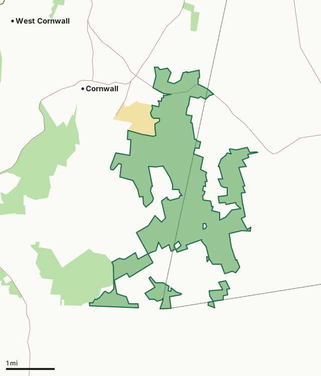
State forestState parkMohawk SF - Clark Pond TractZone lineHighway
| Size | 3,742 acres on DEEP's map; 0.7 square miles of hunting area in DEEP's summary |
|---|---|
| Deer Management Zone | Zone 1, Zone 2 |
| Deer taken, 2025 | 4 (5.71 per square mile, DEEP) |
| Deer taken, 2024 | 1 |
| Deer lottery hunting area | Lottery area 63 |
| DEEP area codes | 341, 342 |
| Nearest towns | Cornwall (next to it), West Cornwall (3 mi) and Cornwall Bridge (3 mi) |
How many deer are taken on Mohawk SF - Clark Pond Tract each year?
| Year | Archery | Muzzleloader | Lottery shotgun | No-lottery shotgun | All deer | Per square mile |
|---|---|---|---|---|---|---|
| 2025 | 3 | 0 | 1 | 0 | 4 | 5.71 |
| 2024 | 1 | 1.43 | ||||
| 2023 | 0 | 0 | 1 | 1 | 2 | 2.86 |
| 2022 | 2 | 0 | 0 | 1 | 3 | 4.29 |
Sources: CT DEEP 2025 Connecticut Deer Program Summary; DEEP 2024 deer summary; DEEP 2023 deer summary; DEEP 2022 deer summary (Appendix 2 of each). A blank cell is a season the year's table does not break out. Per square mile is recomputed by FilledTag from the blocks' added deer and square miles.
How do the blocks of Mohawk SF - Clark Pond Tract compare?
| Block in DEEP's table | Square miles | Deer, 2025 | Deer, 2024 |
|---|---|---|---|
| Mohawk SF - Clark Pond Tract | 0.19 | 2 | 1 |
| Mohawk SF - Ziegler/Johnson Tract | 0.51 | 2 | 0 |
Source: CT DEEP 2025 Connecticut Deer Program Summary, Appendix 2.
When can you hunt deer on Mohawk SF - Clark Pond Tract in 2026?
State land archery runs September 15 to November 17 and December 23 to 31; state land shotgun November 18 to December 8 (lottery A season November 18 to 27); state land muzzleloader December 9 to 22. DEEP's guide lists which of these seasons are open on each state land, and bowhunting-only areas stay open to archery from September 15 to December 31.
| Zone | Private land deer, 2025 | Shotgun/rifle hunter success | Public land |
|---|---|---|---|
| Zone 1 | 432 | 25% | 14.2% |
| Zone 2 | 297 | 12% | 12.1% |
Seasons: CT DEEP 2026 Connecticut Hunting and Trapping Guide. Zone figures: CT DEEP 2025 Connecticut Deer Program Summary.
How do you get to Mohawk SF - Clark Pond Tract?
Highways within five miles: CT 4, CT 63, US 7, CT 45, CT 341 and US 202. Nearest towns: Cornwall (next to it), West Cornwall (3 miles), Cornwall Bridge (3 miles) and Bantam (4 miles).
Questions hunters ask
How many deer are taken on Mohawk SF - Clark Pond Tract?
4 in 2025 (3 archery and 1 lottery shotgun), 5.71 per square mile of DEEP's hunting area (CT DEEP 2025 Connecticut Deer Program Summary, Appendix 2). Earlier: 1 in 2024, 2 in 2023, 3 in 2022.
Is Mohawk SF - Clark Pond Tract a deer lottery area?
Yes. It is in DEEP's deer lottery hunting area 63; shotgun permits there come through the state land lottery, whose regular season runs November 18 to December 8 in 2026 (CT DEEP 2026 Connecticut Hunting and Trapping Guide).
What zone is Mohawk SF - Clark Pond Tract in?
Zone 1 and Zone 2. Hunters took 432 deer on private land in Zone 1 in 2025 (CT DEEP 2025 Connecticut Deer Program Summary).
Get a Connecticut hunt plan when they open
Hunt plans for Connecticut are coming. Join the list and you'll hear first. The first 50 hunters in each new state get their plan free.
Until then, the free FilledTag app for iPhone has a map that works in every state, Connecticut included.
Where these facts come from
- Deer by area: Appendix 2 of CT DEEP 2025 Connecticut Deer Program Summary and the earlier summaries. Boundary: Connecticut DEEP Property.
- Seasons: CT DEEP 2026 Connecticut Hunting and Trapping Guide.
- Public land around it: Connecticut DEEP Property for state land; USGS Protected Areas Database of the United States (PAD-US 4.1) for federal land. Highways and towns: U.S. Census Bureau TIGER/Line 2024 primary and secondary roads; U.S. Census Bureau 2024 Gazetteer, places.
FilledTag is not part of the Connecticut Department of Energy and Environmental Protection.