Idaho controlled hunt 4044: pronghorn of either sex, area 41-2
In Idaho Fish and Game's 2026 drawing, 225 hunters chose hunt 4044 first, for 40 tags: 38 of 197 residents drew (19%) and 2 of 28 nonresidents (7%). In 2025, 34 hunters on this hunt took 13 pronghorn, a 38% harvest success by IDFG's count. The 2026 season is September 25 to October 24, 2026: pronghorn of either sex, muzzleloader only.
Data updated October 2026. Draws: IDFG's 2026 and 2025 controlled hunt drawing results. Harvest: IDFG's harvest statistics through 2025. Season: IDFG Hunt Planner, 2026.
| Species and take | Pronghorn of either sex |
|---|---|
| Weapon | Muzzleloader only |
| Season, 2026 | September 25 to October 24, 2026 |
| Tags in the 2026 drawing | 40 (1 more offered in the second drawing) |
| Hunt area | 41-2, 719,420 acres |
| Unit | 41 |
| Elk zone | Owyhee |
| Public land in the area | 87% (IDFG's land manager figures) |
| Wilderness | Bruneau-Jarbridge Rivers Wilderness 64,706 acres (8.99% of hunt area) |
How many applied for hunt 4044, and how many drew?
Idaho draws controlled hunt tags at random, with no points: each application gets a random number, and tags go to first choices in that order before any second choice is looked at. In 2026, 40 of the 40 tags went to first choices. In a hunt with more than 19 tags, no more than 10 percent may go to nonresidents; with 19 or fewer, no more than one (brochure page 109).
| Drawing year | Tags | First-choice applicants | Residents who drew | Nonresidents who drew | Second choices: drew of applied | Second drawing: tags issued of offered |
|---|---|---|---|---|---|---|
| 2026 | 40 | 225 | 38 of 197 (19%) | 2 of 28 (7%) | 0 of 68 | 1 of 1 |
| 2025 | 40 | 245 | 36 of 208 (17%) | 4 of 37 (11%) | 0 of 80 | 2 of 2 |
Source: IDFG, pronghorn controlled hunt drawing odds, 2026 and 2025, first and second drawings. "Drew" is IDFG's count of tags issued to that group's first choices; the percentage is worked out from IDFG's two figures.
How has the draw for hunt 4044 changed?
IDFG's records go back to 2014 for this hunt: 147 first-choice applicants for 40 tags then, 225 for 40 in 2026.
| Year | Hunt number that year | Tags | First-choice applicants | First choices who drew | Residents: applied, drew | Nonresidents: applied, drew |
|---|---|---|---|---|---|---|
| 2026 | 4044 | 40 | 225 | 40 (18%) | 197, 38 | 28, 2 |
| 2025 | 4044 | 40 | 245 | 40 (16%) | 208, 36 | 37, 4 |
| 2022 | 4046 | 40 | 211 | 40 (19%) | 190, 36 | 21, 4 |
| 2021 | 4046 | 40 | 195 | 40 (21%) | 178, 36 | 17, 4 |
| 2020 | 4041 | 40 | 205 | 40 (20%) | 190, 37 | 15, 3 |
| 2019 | 4041 | 40 | 264 | 40 (15%) | 247, 38 | 17, 2 |
| 2018 | 4041 | 40 | 177 | 40 (23%) | 161, 36 | 16, 4 |
| 2016 | 4039 | 40 | 173 | 40 (23%) | 161, 36 | 12, 4 |
| 2015 | 4039 | 40 | 139 | 40 (29%) | 131, 39 | 8, 1 |
| 2014 | 4039 (area 41) | 40 | 147 | 40 (27%) | 139, 37 | 8, 3 |
First drawing only. IDFG's Hunt Planner lists these years for this hunt, under the hunt number (and, where it differs, the area) used that year (Hunt Planner, hunt 4044). IDFG rounds its success percentages.
What is the harvest success on hunt 4044?
In 2025, 34 hunters reported on hunt 4044 and 13 took an animal: 38% success, over 167 days of hunting. Across the 5 most recent years in the table, 50% of hunters took an animal.
| Year | Hunt number that year | Hunters | Harvest | Success | Days hunted |
|---|---|---|---|---|---|
| 2025 | 4044 | 34 | 13 | 38% | 167 |
| 2022 | 4046 | 34 | 24 | 70% | 113 |
| 2021 | 4046 | 37 | 20 | 55% | 128 |
| 2020 | 4041 | 36 | 15 | 42% | 127 |
| 2019 | 4041 | 34 | 16 | 46% | 117 |
| 2018 | 4041 | 34 | 22 | 62% | 112 |
| 2016 | 4039 | 30 | 13 | 43% | 62 |
| 2015 | 4039 | 36 | 15 | 43% | 121 |
| 2014 | 4039 (area 41) | 39 | 12 | 32% | 132 |
| 2013 | 4039 (area 41) | 40 | 16 | 40% | 150 |
IDFG's success percentages are its own and can differ slightly from harvest divided by hunters. From IDFG's mandatory hunter reports and check stations, as its Hunt Planner prints them for this hunt (hunt 4044) and its harvest statistics.
Where is hunt area 41-2?
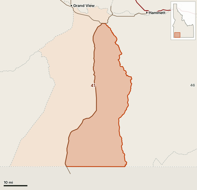
IDFG's description of hunt area 41-2: That portion of Unit 41 east of State Highway 51.
It covers 719,420 acres.
| Land manager in area 41-2 | Share |
|---|---|
| U.S. Bureau of Land Management (BLM) | 80.77% |
| Indian Reservation / Bureau of Indian Affairs | 7.37% |
| Private | 6.01% |
| State of Idaho | 5.75% |
Land cover, by IDFG's figures for the area: rangeland 90.78% and riparian 7.81%.
Wilderness in the area: Bruneau-Jarbridge Rivers Wilderness 64,706 acres (8.99% of hunt area). No motorized vehicles are allowed in wilderness.
Area facts: IDFG Hunt Planner, hunt area 41-2; land managers from IDFG's surface management data (Inside Idaho), land cover from IDWR.
What rules come with hunt 4044?
- Antlerless or Antlered Pronghorn Antelope. Either sex may be taken.
- Muzzleloader. Muzzleloader ONLY.
Other 2026 pronghorn hunts in unit 41: 4009 (41-1), 4030 (40-1), 4031 (40-1). All pronghorn draw results.
Questions hunters ask
How many people applied for Idaho hunt 4044 in 2026?
225 hunters listed hunt 4044 as their first choice in IDFG's 2026 drawing, for 40 tags. 38 of 197 resident first choices drew, and 2 of 28 nonresident first choices.
What is the harvest success on Idaho hunt 4044?
IDFG reports 34 hunters took 13 pronghorn on hunt 4044 in 2025, 38% success. Over the last 5 years IDFG lists for this hunt, 50% of hunters took an animal.
When is Idaho hunt 4044 in 2026?
September 25 to October 24, 2026. It is pronghorn of either sex, muzzleloader only, in hunt area 41-2 (IDFG Hunt Planner).
Which units are in Idaho hunt area 41-2?
IDFG describes hunt area 41-2 as: "That portion of Unit 41 east of State Highway 51." It covers 719,420 acres.
Get your free Idaho plan
FilledTag plans Idaho's general elk and deer seasons: a specific, legal place to park, camp and sit for your tag and your dates, with the walks between them, checked against land records. The first 50 Idaho plans are free, one per hunter, for hunters who hold or will hold an Idaho general elk or deer tag. Every Idaho plan is looked over by a person before it is sent.
Get your free Idaho plan for unit 41 See a real plan
Not ready to order yet? Leave your email and you get one email when paid Idaho plans open, if the free ones have gone by then.
Where these numbers come from
- Drawing: IDFG controlled hunt drawing odds, 2025 and 2026.
- History, harvest and area: IDFG Hunt Planner, hunt 4044 and hunt area 41-2; IDFG harvest statistics.
- Season and rules: IDFG, Idaho Big Game 2026 Seasons and Rules and the Hunt Planner; nonresident limit from the big game brochure, page 109.
FilledTag is not part of Idaho Fish and Game. Hunt numbers change from year to year: use the current brochure when you apply. Nothing on this page predicts a future draw.
Idaho pronghorn draw results Unit 41 Owyhee Zone Idaho deadlines and fees