Monroe County, Indiana: deer harvest and public hunting land
Monroe County covers 411 square miles around Bloomington. Hunters took 1,652 deer here in the 2025 season, 780 of them antlered, by the DNR's deer report. That is up 18% from 2024, and the most in the 5 years shown. 22.5% of Monroe County is public land open to the public, the largest share properties open to public hunting (DNR map) (40,030 acres), by USGS PAD-US 4.1 and the DNR's public hunting property boundaries.
Data updated October 2026. Harvest: the DNR's deer reports, 2021 to 2025. Land: PAD-US 4.1 and the DNR's public hunting property layer.
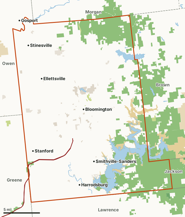
Properties open to public hunting (DNR map)National forestFederal land, mostly Corps of Engineers lakesState parksOther DNR landCounty, city and regional landLand trusts and other open landMonroe CountyNeighboring countiesLakeHighway
| Size | 263,275 acres (411 square miles) |
|---|---|
| Deer taken, 2025 | 1,652 (780 antlered, 872 antlerless) |
| Public land | 22.5% (59,122 acres) |
| Public hunting properties | 6 (40,031 acres inside Monroe County) |
| Towns in and near it | Bloomington, Ellettsville, Stinesville, Gosport, Paragon and Spencer |
How many deer are harvested in Monroe County?
Hunters took 1,652 deer in Monroe County in 2025: 780 antlered and 872 antlerless (53% antlerless).
| Season | Deer taken | Antlered | Antlerless |
|---|---|---|---|
| 2025 | 1,652 | 780 | 872 |
| 2024 | 1,397 | 682 | 715 |
| 2023 | 1,457 | 676 | 781 |
| 2022 | 1,407 | 688 | 719 |
| 2021 | 1,423 | 723 | 700 |
Source: Indiana DNR White-tailed Deer Reports (2021 to 2025 seasons, Table 3-4), Monroe County.
How much public land is in Monroe County?
59,122 of Monroe County's 263,275 acres are public land open to the public (22.5%). The biggest share is properties open to public hunting (DNR map): 40,030 acres.
| Manager | Acres | Share of Monroe County |
|---|---|---|
| Properties open to public hunting (DNR map) | 40,030 | 15.2% |
| Federal land, mostly Corps of Engineers lakes | 14,062 | 5.3% |
| County, city and regional land | 2,452 | 0.9% |
| Land trusts and other open land | 1,781 | 0.7% |
| Other DNR land | 367 | 0.1% |
| National forest | 339 | 0.1% |
| State parks | 88 | under 0.1% |
| National wildlife refuges | 3 | under 0.1% |
| All public land open to the public | 59,122 | 22.5% |
Measured by FilledTag inside the county line from USGS PAD-US 4.1 (fee land open to the public) and the DNR's public hunting property boundaries. Hunting rules differ by manager: properties on the DNR's public hunting map are open under the DNR's rules for each; national forest is open; refuges follow U.S. Fish and Wildlife Service rules; Corps of Engineers lake land is open in many places under each project's own rules; state parks hold only special hunts; city and county land sets its own rules.
Properties open to public hunting in Monroe County
Properties open to public hunting in Monroe County, largest first, with the acres of each inside it:
- Morgan-Monroe State Forest: 19,297 acres
- Hoosier National Forest: 18,830 acres
- Monroe Lake: 1,210 acres
- Yellowwood State Forest: 337 acres
- Martin State Forest: 280 acres
- Muscatatuck National Wildlife Refuge: 77 acres
Other large public areas here, by PAD-US: Monroe Recreation Area (16,395 acres).
How do you get to Monroe County?
Highways through it: I-69 (about 19 miles inside). Towns inside: Bloomington, Ellettsville, Stinesville, Smithville-Sanders, Harrodsburg and Stanford. Nearby: Gosport (on the line), Paragon (4 miles), Spencer (5 miles) and Martinsville (5 miles).
Which counties border Monroe County?
Monroe County touches 6 other counties. Their latest DNR harvest and public land, for comparison:
| County | Deer harvested | Year | Public land |
|---|---|---|---|
| Owen County | 2,277 | 2025 | 5.5% |
| Brown County | 1,400 | 2025 | 33.7% |
| Greene County | 2,158 | 2025 | 5.6% |
| Morgan County | 1,701 | 2025 | 3.6% |
| Jackson County | 1,232 | 2025 | 11.8% |
| Lawrence County | 2,381 | 2025 | 6.4% |
Questions hunters ask
How many deer were harvested in Monroe County in 2025?
1,652: 780 antlered and 872 antlerless (DNR). In 2024: 1,397.
Is there public hunting land in Monroe County?
59,122 acres, 22.5% of the county, are public land open to the public by USGS PAD-US 4.1 and the DNR's public hunting property boundaries, the largest share properties open to public hunting (DNR map) (40,030 acres). The DNR's map shows 6 properties open to public hunting here.
What is the deer bag limit in Monroe County?
Indiana's statewide limit is 1 antlered and 6 antlerless deer; each county has its own antlerless limit within that, on the DNR's county antlerless bag limit list.
Get a Indiana hunt plan when they open
Hunt plans for Indiana are coming. Join the list and you'll hear first. The first 50 hunters in each new state get their plan free.
Until then, the free FilledTag app for iPhone has a map that works in every state, Indiana included.
Where these numbers come from
- Deer harvest: Indiana DNR White-tailed Deer Reports (2021 to 2025 seasons, Table 3-4).
- Public land: USGS PAD-US 4.1 (fee land open to the public) and the DNR's public hunting property boundaries. DNR properties open to hunting: Indiana DNR properties with public hunting (managed lands layer).
- Boundaries: U.S. Census Bureau 2024 cartographic county boundaries. Highways and towns: U.S. Census Bureau TIGER/Line 2024 primary and secondary roads; U.S. Census Bureau 2024 Gazetteer, places.
FilledTag is not part of the Indiana Department of Natural Resources. Numbers are copied from the DNR and the federal sources above, or measured from their maps; nothing on this page is estimated by FilledTag.
Indiana hunting Owen County Brown County Greene County Morgan County Jackson County Lawrence County